Around 5:07am, August 11th (JST; Aug 10th 8:07pm UT), 2009, a M6.4 earthquake (according to USGS) occurred at Suruga Bay. The largest intensity observed was 6-, and it was a felt earthquake in a wide area including the Kanto and Koshin’estu Regions. Tsunamis were observed at and around the Suruga Bay.
Following is a report of this earthquake. (Outreach Office)
[Updated]
- Damage on the stone wall of Sumpu Castle (Aug 26)
- Source process inversion (Aug 25)
- Observation of aftershocks and aftershock activities (Aug 22)
- Record of the barometer (Aug 20)
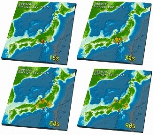
- Aftershock Activities updated, time-shift made into animation (Aug 16)
- Earthquakes of the past (Aug 16)
- Analysis result of GPS observation (Aug 12)
- Suruga Kuno-san Earthquake on April 22nd, 1841 (March 2nd, Tempo 1841) (Aug 12)
- Summary by the Strong Motion Seismology Group – No.1 can be seen in English (Aug 16)
- Smoked-paper recording (Aug 12)
- GRiD MT Broadband Seismograph Record Image (J-array Observed Waveform) (Aug 11)
- Summary by the Strong Motion Seismology Group – No.2 (Aug 11)
[Summary]
Location of the source, magnitude and the type of the earthquake
- N34.8, E138.5, depth 20km, Mj 6.5 (JMA)
- intraslab earthquake (includes reverse fault component and strike-slip component)
Relation to the Supposed Tokai Earthquake (announced by JMA)
- this earthquake is not the Supposed Tokai Earthquake
- - the magnitude differs greatly (M8 is assumed for the Supposed Tokai Earthquake but the Suruga Bay earthquake on the 11th was M6.5)
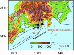
- - it is an intraslab earthquake (the Supposed Tokai Earthquake is a boundary earthquake on the upper side of the Philippine Sea plate
- it is not an earthquake that would trigger the Supposed Tokai Earthquake
[Summary by the Strong Motion Seismology Group - No.1]

The red star indicates the earthquake on Aug 11, 2009, Mw6.2, depth 23km (click for further information)
