Around 4:55pm, September 2nd, 2009 (Japan time, 2:55pm local time), an earthquake occurred off south coast of Java, Indonesia. A tsunami warning was issued, however, it was cleared soon after.
We will update information on this earthquake. (from the“Multi-disciplinary Hazard Reduction from Earthquakes and Volcanoes in Indonesia”, Kenji SATAKE, Teruyuki KATO, summarized by Outreach Office)
[Updated]
- Records of tide gauge and gravity meter (Sept 7)
- “Epicenter Location Map” updated on “Tectonics Background” (Sept 6)
- “GPS Observation” updated (Sept 6 ; Field Investigation revised)
- “Cooperate Research by Indonesia and Japan” ( updated Sept6)
- “Waveforms observed by the Ocean Hemisphere Network Project”updated (Sept 5)
- Figure added to “Tectonics Background” and revised ( Sept 5 )
- “Cooperate Research by Indonesia and Japan”(Sept 4)
- “Field Investigation” (Sept 4)
- “Earthquake on September 2nd, 2009″ (Sept 4)
- “Tectonics background” (Sept 4)
- Links
[Overview]
Location of the source and magnitude
- S7.78, E107.33, 49.9km deep, M7.0 (USGS)
[Tectonics Background]
At Sumatra and Java, the main islands of Indonesia, the Australian plate subducts from the south and has a background similar to that of Japan. From the shape of the island arc, Sumatra subducts obliquely towards the trench, and Java subducts almost orthogonally. The Sumatra fault, a massive active fault, runs through Sumatra, along with many volcanoes on both Sumatra and Java. On December 26th, 2004, a powerful earthquake over M9 jolted regions from northern Sumatra to the Andaman Islands, generating an enormous tsunami around the Indian Ocean, victimizing more than 200,000 people in the area. The crustal activity became active at Sumatra and the surrounding areas, leading to continuous large earthquakes along the trench, such as the Nias earthquake in March 2005, the Pangandaran earthquake in July 2006, and the Bengkulu earthquake in September 2007. We have also observed the activation of Mt. Merapi, other surrounding volcanoes, and the inland earthquakes near Yogyakarta in June 2006, which resulted in more than 6,000 casualties.
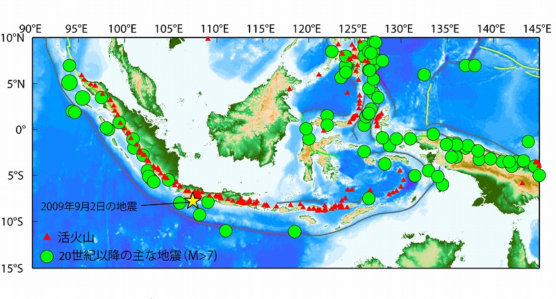
Figure 1: Location of Indonesia and the surrounding large earthquakes and active volcanoes (Click to enlarge)
Figure 2 placed below is the GPS observation result which took place in Indonesia and the surrounding areas in 1991-2001 (Bock et al., 2003). What is remarkable from this figure is that the dislocation of Sumatra and Java differs greatly. The southwest of Sumatra has dislocated towards the northeast from the affect of the subducting Australian Plate, while at Java, there are no plate subductions, though it is dislocated towards the east. This indicates that at Java, the subduction plate is not locked firmly to the overriding plate. Tsunami earthquakes, which generate tsunamis and are larger than the estimated magnitude, have actually hit south coast of Java in 1994 and 2006. The eastward movement of Java can be observed similarly in the north from Borneo and the Malay Peninsula to the northeast coast of Sumatra and shows a steady rigid movement. Although it is not indicated in the figure, Indochina shows a similar movement. Therefore, the region is referred to as the “sundablock”.
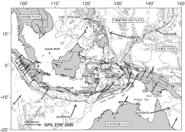
Figure 2 : Indonesia and the GPS displacement of the surrounding area (ITRF 2000) (Bock et al., JGR, 2003 )

click to enlarge
Figure 3 : Earthquake location in the vicinity of Java (PDE catalog; data from 1973 to September 4th, 2009). To the right is a closeup of the figure on the left, with the depth of the source up to 150km.
[ Earthquake on September 2nd, 2009 ]
The earthquake occurred northwest of the Pangandaran earthquake (a Mw 7.5 earthquake with the tsunami leading to many casualties) that occurred off south coast of Java in July 2007. According to information such as the website of USGS, it is an eastwest-compressed reverse faulting with the epicenter at approximately 50km deep, and the earthquake seems to have occurred within the subducting Australian plate. The Suruga Bay earthquake on August 11th is similar to this. That is, both earthquakes occurred inside the subducting plate with the compression axis being nearly perpendicular towards the plate.
As for the Suruga Bay earthquake, it is described that such stress axis is due to the collision of the Izu Penninsula, though such a stress field cannot be considered at Java, and needs an investigation of how it came to have such a mechanism.
[GPS Observation]
ERI has started a temporary GPS observation at southwestern Java immediately after the Pangandaran earthquake in July 2006, and has been conducting a campaign observation once every year since then. We consider that the displacement caused by this earthquake would be detected if an immdiate GPS observation at the same location was conducted. The National Coordination Agency for Surveys and Mapping (of Indonesia) has placed several continual stations in this region as well.
Figure 1 below shows the location of the GPS observation in south Java. it indicates the locations which were considered when the earthquake hit Pangandaran along with the tsunami in Juy 2006. The blue dots indicate the stations placed at the time. The earthquake on September 2nd took place slightly west to the stations placed at the time. The first group of the ITB has left for observation, on September 3rd. Refer to Kato et al., (2007) for GPS observation of the Pangandaran earthquake in 2006.
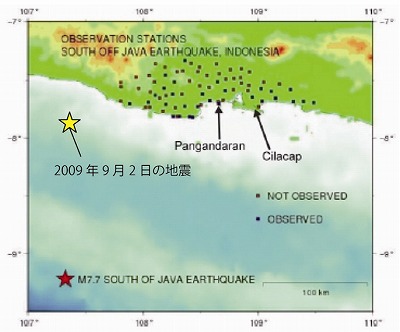
Figure 1: GPS observation stations at southern Java. The red and yellow stars respectively indicate the epicenter of the Pangandaran earthquake in July 2006, and the epicenter of the earthquake on Spetember 2nd (added on Kato et al., 2007).
[ Cooperate research by Indonesia and Japan ]
In the wake of the Sumatra-Andaman earthquake in December 2004, a number of cooperate researches among the Asian countries including Indonesia and Japan has been activated. The interdisciplinary research groups at ERI have conducted the “Restoration Program from Giant Earthquakes and Tsunamis” (Research group representative: Teruyuki KATO) during the three years of 2005-2007, and in 2009, we have also initiated a new project, the “Multi-disciplinary Hazard Reduction from Earthquakes and Volcanoes in Indonesia”(Research group representative: Kenji SATAKE), by the Science and Technology Research Partnership for Sustainable Development launched with the cooperation of MEXT ( Ministry of Education, Culture, Sports, Science & Technology ) and the Ministry of Foreign Affairs.
Temporary investigation research other than the GPS observation, such as the sociological local field investigation, investigation of the affect to volcanic activities are being planned after the earthquake on September 2nd.
[ Waveforms observed by the Ocean Hemisphere Network Project]
The Ocean Hemisphere Network Project is a project to lay out a network in the pacific ocean hemisphere for overall observation of the global activities such as seismic, electro-magnetic, geodetic and crustal movements to unveil the activity of the earth in a global scale. We have achieved greatly ever since the project has been launched in 1996. Visit “Ocean Hemisphere Network Project -New Eyes to See the Interior of the Earth-” for further information.)
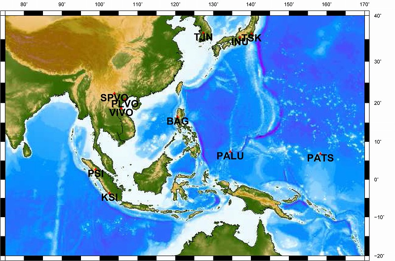
Figure 1 : Location of observation stations ( Click figure to enlarge )
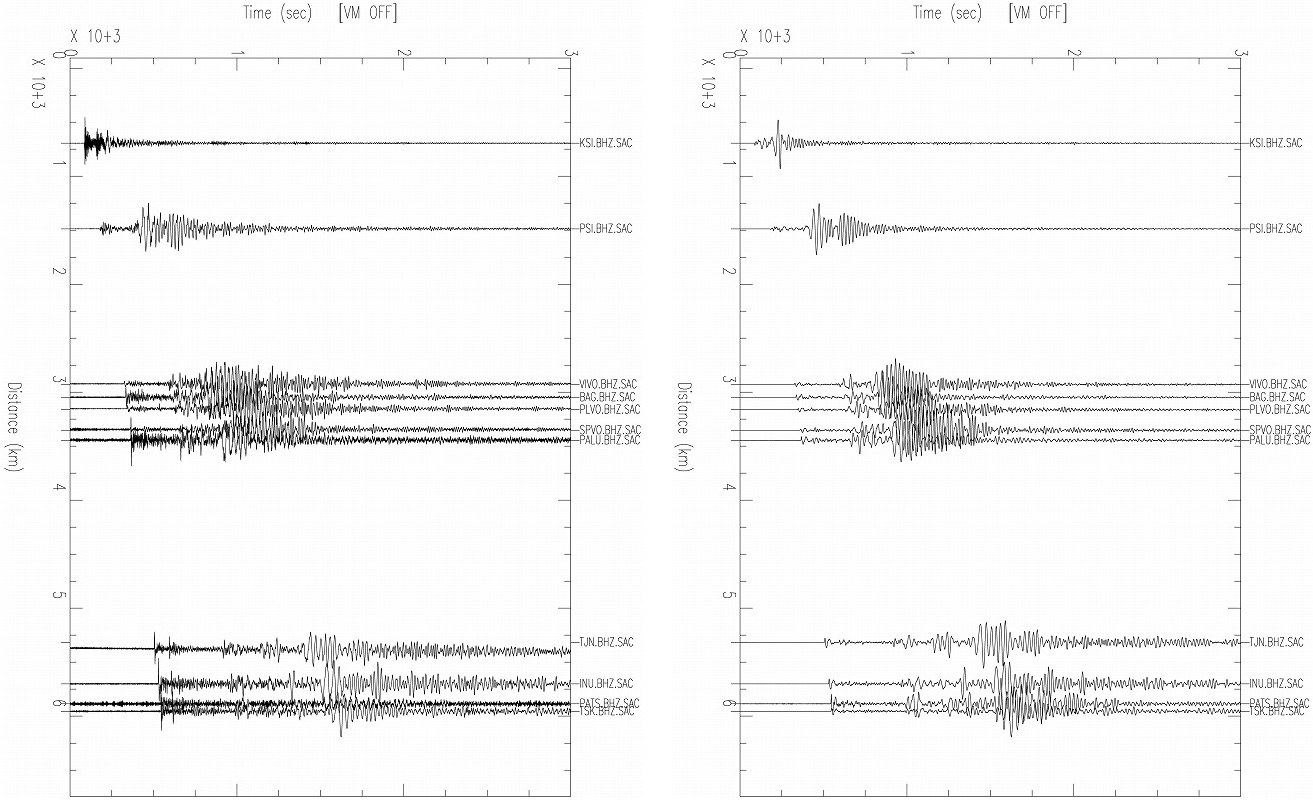
Figure 2: Observed waveforms. To the right: After a bandpass filter of 20-100 sec. The P-wave, S-wave, then the wide-amplitude surfacewaves can be observed.
by the Ocean Hemisphere Research Center
[ Records of the tide gauge and the gravity meter ]
The National Coordinating Agency for Survey and Mapping (BAKOSURTANAL)of Indonesia has announced that both gravity change and tsunami waves were recorded on the gravity meter and the tide gauge after the earthquake. Following is an abridged translation of the article on the website of BAKO. Refer to the link for the actual article and figures.
September 3rd, 2009, the gravity meter at BAKO had recorded the earthquake off south coast of west Java. Two of the tide gauges of BAKO also recorded the change of the sea level immediately after the earthquake. The tide gauges at the coast line of Pameundpeuk, Garut, a place rather close to the epicenter (blue line), and Sukabumi, Pelabuhan Ratu (green line) both show different patterns of before and after the earthquake. The difference of the amount of change at Pameundpeuk (blue line) and Pelabuhan Ratu (green line) can be seen as well.
(Abridged tranlsation by Yoshimi NISHI, Research Assoc. of The University of Tokyo Graduate School of Arts and Sciences.)
[ Links ]
- Multi-disciplinary Hazard Reduction from Earthquakes and Volcanoes in Indonesia ( Research representative, Kenji SATAKE )
- USGS “Java, Indonesia”
- NIED “Java, Indonesia, September 2, 2009″