According to USGS, an earthquake of Mw7.6 occurred off the Sumatra Islands in western Indonesia (0.789°S, 99.961°E, 80km deep) at 7:15pm (Japan time. 5:15pm local time) on September 30th, 2009.
We will update information on this earthquake. (Outreach Office)
[Updated]
- Cooperate research by Indonesia and Japan
- Focal mechanism by W-phase seismogram
- Waveforms observed by J-array
- Image added to Tectonics Background
- Tectonics Background
- Abstracts
- Links
[Abstracts]
- it is not related to the earthquake at Samoa at 2:48am, on September 30th
- from the depth of the epicenter and the mechanism, it is considered as an earthquake within the Australian plate
[Tectonics Background]
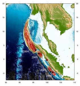
Sumatra Island is located where the Australian plate subducts towords NE beneath the Sunda plate (Eurasia plate), and it is one of the earthquake-active areas in the world. The Sumatra earthquake in 2004 (M9.1, USGS), which resulted in over 200,000 deaths occurred in the northern area of this earthquake. M8.5-class earthquakes had also hit the area in 2005 and 2007.
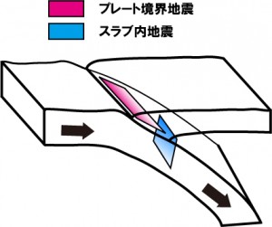
The image above shows the Australian plate subducting beneath the Sunda plate. Earthquakes occurring between two plates are called ‘interplate earthquakes’ (pink), and earthquakes occurring inside the subducting plate are called ‘slab earthquakes’ (blue). The sequencial Sumatra earthquakes in 2004, 2005 and 2007 were an interplate erathquake whereras this earthquake on Sept 30th was a slab earthquake which occurred in the blue section of the image.
The sequencial earthquakes off Sumatra Islands had been taking place on the plate boundaries, but this September 30th earthquake is considered to have occurred within the subducting plate — the epicenter is 80km deep (the plate boundaries in the area is considered to be less than 50km deep), and the compression axis of the fault mechanism is not parallel to the subducting direction.

Source region of the sequencial Sumatra earthquakes. The red star indicates the Sept 30th earthquake. (added to Ishii et al., 2005)
[Waveforms observed by J-array]
Earthquake Information Center
[ Focal Mechanism by W-phase Seismogram ]
strike / dip / slip fault surface1: 152.2 / 41.1 / -87.7
fault surface2: 329.2 / 49.0 / -92.0
by Yusuke YOKOTA (MC2)
[Cooperate Research by Indonesia and Japan]
In the wake of the Sumatra-Andaman earthquake in December 2004, a number of cooperate researches among the Asian countries including Indonesia and Japan has been activated. The interdisciplinary research groups at ERI have conducted the “Restoration Program from Giant Earthquakes and Tsunamis” (Research group representative: Teruyuki KATO) during the three years of 2005-2007, and in 2009, we have also initiated a new project, the “Multi-disciplinary Hazard Reduction from Earthquakes and Volcanoes in Indonesia”(Japanese only) (Research group representative: Kenji SATAKE) by the Science and Technology Research Partnership for Sustainable Development launched with the cooperation of MEXT ( Ministry of Education, Culture, Sports, Science & Technology ) and the Ministry of Foreign Affairs.

