Sakurajima Volcano
(June 10, 2006)
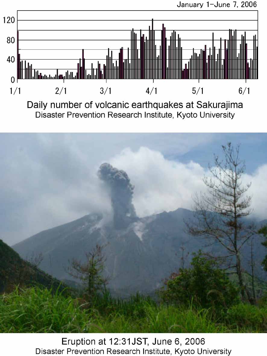
On June 4, 2006, eruption started
on the Showa crater in the middle of the eastern slope of the Minamidake,
which is different from recent active craters in the summit of the Minamidake.
The Showa crater with the about 800 m altitude was formed in the 1946 eruption
(Showa eruption). the eruption intermittently continued, including the June
7 evening eruption which sent the ash column about 1,000 m above the crater.
The number of shallow low-frequency
(B-type) earthquakes had increased since the middle of March 2006, and that
of small volcanic tremors with the duration shorter than 2 minutes had increased
since the middle of May. The GPS data show that continuation of inflation
in the northern part of the Aira caldera which is considered due to magma
supply.

Fig. 1 Volcano earthquakes and
photo of eruption from the Show crater. Courtesy of Sakurajima Volcano Research
Center, (former Sakurajima Volcano Obervatory), Disaster Prevention Research
Institute, Kyoto University.
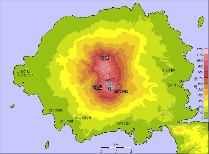
Fig. 2 Map showing
distribution of active craters on Sakurajima Volcano. The Showa crater that
was formed prior to the 1946 eruption, is located on the eastern slope of
the Minamidake cone. Courtesy of SVRC.
Professor Kazuhiro Ishihara,
the director of Sakurajima Volcano Research Center, Disaster Prevention Research
Institute, Kyoto University, gave his personal comments on this eruption
as follows;
Outline:
The present eruption is considered to be a part of the activity where magma
accumulated in the Aira caldera searches for the exit. Should keep attention
on the eruptive progress in this crater together with any change in activity
under Sakurajima and in the Aira caldera for the time being.
Background:
It is considered that, in the Aira caldera, the Kagoshima Bay just north
of Sakurajima, magma has been accumulated in the volume as much as about
80% of magma issued in the 1914 (Taisho) eruption based on leveling and GPS
observation data. About 10 million cubic meter has been accumulated during
these ten years.
Eruptive activity which began at the summit of the Minamidake in October
1955 declined with time after 1993, such that only 100 thousand tons of
ash was issued every year after 2001, contrasting 10 to 30 million tons
every year in 1980s. It seems that the magmatic conduit to the summit had
been choked. However, there are no data supporting ascent or intrusion of
large amount of magma to beneath Sakurajima presently.
For this reason, the activity of A-type, relatively deep volcano earthquake,
increased since 2003, and more than 20 of earthquakes including M2.8 occurred
on April 23, 2003, the seismic activity was elevated both in depth of about
10 km in the southwest of Sakurajima and in the Aira caldera from the fall
of 2003 to the next year. Shallow, low-frequency earthquakes (B-type) increased,
the amount of steam from the Show crater increased, and the thermal anomaly
region in the same crater expanded since February 2006.
Future activity:
The increase in volcanic activity in Sakurajima is probably unavoidable.
There are some possible scenarios; (1) Intensifying of the summit eruptive
activity like the eruptions during 1970-1989. (2) Generation of pyroclastic
flow and effusion of lava from the middle slope such as the 1946 (Showa)
eruption. Or, (3) large-scale eruptions from the flank of the volcano including
in the sea bottom such as the 1470 (Bunmei), 1779 (An-ei), and 1914 (Taisho)
eruptions. Although presently it difficult to point out the future scenario
strictly, it is hard to imagine the rapid development into large eruptions
without any signs. The following 3 steps are plausible prior to large eruptions;
(1) Showa crater and the summit crater:
Eruption had been repeated in two summit craters (A and B) these 40 years.
The Showa crater is expected to be widened with the increase in activity.
There is high possibility of generation of pyroclastic flows in this process.
(2) Seismisity:
With elevation of seismisity, volcanic earthquakes increase in and around
the volcano. Sudden intrusion or uprising of magma is accompanied by frequent
occurrence of felt quakes.
(3) Ground deformation in Sakurajima and the Aira caldera:
Whether the
volcanic activity suddenly increases or not, depends mainly on acceleration
of movement of magma to beneath Sakurajima, such that the center of upheaval
migrated from the Aira caldera to Sakujama, prior to the activity starting
in October 1972. This example is one of keys to evaluate the moving into large
eruption.
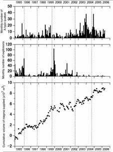
Fig. 3 Monthly numbers of A-type earthquakes
and explosions at Sakurajima last decade (January 1995-May 2006). Courtesy
of SVRC. Volume of magma supplied into the magma reservoir under the Aira
caldera was estimated based on GPS data.
The initial sign of the present eruption was not detected timely due to its
small scale. However, Mt. Tetsuro Takayama, a technician of SVRC, who has
served for 38 years in the center, confirmed the beginning of the eruption
around 11:40 JST on Sunday, June 4, and, then, the center started the inspection,
reporting the eruption to the weather station of JMA and the Kagoshima Prefecture
Government.
Professor Ishihara asked local people in and around the Sakurajima island,
who noticed any abnormal phenomena described in the disaster map distributed
to every home this March, to send their information to either of government
office, city office, fire and police stations, weather station, etc, as soon
as possible. In the case of the Taisho eruption, felt quakes began a few
days before the eruption and local people started to take refuge two days
before, though mayors of Higasih- and Nishi-Sakurajima villages reported
frequent occurrence of felt quakes to the weather station a day before, on
Sunday when the offices were closed. They had to meet the large eruption
without enough information nor confirmation on the phenomena.
Information contact: Sakurajima Volcano Research Center, DPRI-Kyoto
University; Volcano Research Institute, ERI-University of Tokyo
Link to: DPRI-Kyoto University
Return
using back bottom