3. Activities of Kuju and Aso volcanoes
Kuju Volcano
Kuju Volcano lies near Aso Caldera in the center of the Beppu-Shimabara Graben of the central Kyushu. After a few hundred years of dormancy (Imura and Kamata, 1996), a phreatic eruption began with the ejection of about 20,000 m**3 ash on 11 October 1995. A number of new vents have opened on a series of lines striking east-west on the eastern slope (an area named Ioyama) of Mt. Hossho, one of the domes of the Kuju complex, a few hundred meters from a pre-existing fumarolic area. After the eruption there has been continuous steam emission from the new vents. There was the second ash eruption in December 1995, and a very small ejection of ash in March 1996. Before these eruptions, seismic events were rarely observed, either near the site of the new vents, or elsewhere under Kuju Volcano. The recent volcanic activity has been continued with steam ejection from the new vents.
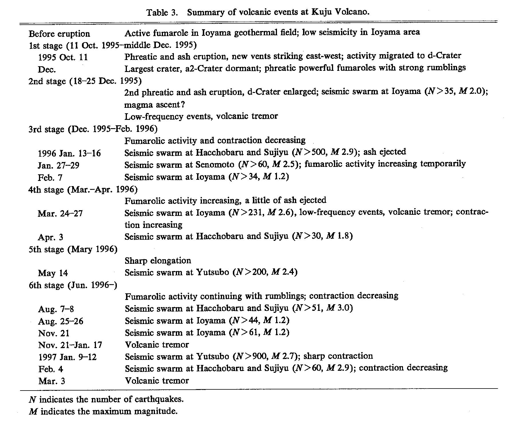
Table 3 indicates the preliminary summary of the volcanic activity of Kuju Volcano from the eruption on October 1995 (Sudo et al., 1998). Before the first eruption on October 1995, there were three geothermal fields in the Ioyama area, named A-, B- and C-fields, with many fumaroles (Fig. 8). These geothermal fields remain active after the eruption. In an area 3 - 5 km to the northwest from Ioyama, the Hacchobaru, Sujiyu and Yutsubo geothermal regions, seismic swarms have occurred (Figs. 9 and 10). At two of these regions, Hacchobaru and Yutsubo, steam is extracted from underground to supply geothermal power plants.
From the morning of 11 October 1995 three or more white plumes were witnessed to be rising up just above Ioyama. During the evening these plumes became black with rumblings and felt-shocks. On the morning of next day, 12 October, ash cloud was observed to rise up to about 1 km. The gross volume of ejected ash was estimated to be about 20,000 m**3. There were no remarkable precursory indications of the end of several hundred years of dormancy. The new vents formed five lines, a series of fissures striking east-west. The alignment of these fissures shows a left-lateral relationship. The largest crater was with a diameter of 30-40 m. Fumaroles were powerfully emitting steam with strong rumblings.
Seismic Activity: Since the first eruption several thousand earthquakes have been recorded. These events have been very horizontally concentrated just to the north of the new vents vertically between 800 m above sea level and 1,000 m below sea level. Very few earthquakes have been located on the southern side of the new vents. There was clearly a strong high-frequency attenuation affecting the seismic waves which passed through the region beneath the new vents to the seismometers south of Mt. Hossho. This evidence possibly indicates a thermal fluid content beneath the new vents, suggesting that there is a seismic attenuating zone in the feeding area of the new vents. Nearly all the earthquake spectra were dominantly high frequency, but the percentage of earthquakes with predominantly low frequency spectra increased at times of enhanced volcanic activity. Volcanic tremor was also sometimes observed around the times of peak activity. From 13 to 14 January 1996, a seismic swarm occurred in Sujiyu and Hacchobaru geothermal regions. During this swarm period, a small amount of ash was ejected from d-Crater. Fumarolic activity gradually decreased during this period. On 27 to 29 January, a swarm occurred in the Senomoto region, about 5 km southwest from the new vents, and this swarm coincided with a short lived increase of fumarolic activity from the new vents. A seismic swarm occurred near the new vents on 24 March and then volcanic tremor occurred until 27 March. At the same time, the fumarolic activity again increased, and a very small amount of ash was ejected from the new vents and was observed as thin layers in drifted snow.
The hypocenters of these earthquakes are shown in Fig. 10. These earthquakes fell into two clear groups. One group originated near the new vents just east of Mt. Hossho and this group was called Ioyama seismic events. Nearly all the other group originated a few kilometres northwest of Kuju Volcano, around Hacchobaru, Sujiyu and Yutsubo geothermal regions, in an arc from west to north respectively. Fig. 9 indicates the daily frequencies of seismic event occurrences at Ioyama seismic group and other group including Ioyama group, respectively.
Ioyama seismic events: To the north of the new vents the seismicity has a very small horizontal extent and extended vertically between 800 m above sea level and 1,000 m below sea level, but concentrated above sea level. This seismic activity was clearly associated with the new volcanic activity of Kuju Volcano after the eruption in October 1995. There is a particularly sharp boundary to the south of the area of seismicity, suggesting a completely aseismic area in this region, which includes the new vents. It is also interesting that there is no seismicity higher than 800 m in elevation. This perhaps indicates that the material being deformed in the seismic gap region above 800 m in elevation is very weak and fails aseismically. Several local seismic swarms occurred in the Ioyama area as shown in Table 3. Of these swarms, only the one that occurred on December 1995 had an obvious relation with the surface volcanic activity, as it coincided with the second ash eruption, as already mentioned. However, for the comparatively large seismic swarm in late March 1996, with a maximum event magnitude of 2.6, there may have been surface volcanic changes that could not be observed due to the bad weather conditions.
Seismic events around Kuju volcanic region: To the northwest of Kuju Volcano, in the Hacchobaru, Sujiyu and Yutsubo geothermal regions, seismic events often occurred before the eruption of October 1995. Their focal mechanisms indicated normal and/or right lateral strike slip fault types corresponding to the crustal activity in the central Kyushu graben (Shimizu et al., 1993; Sudo, 1993; Tada, 1993). This seismic area often had significant local swarms of about 100 earthquakes occurred in a limited region, during a few hours or a day. These swarms seem to have been more common after the commencement of the eruption of Kuju Volcano. After the eruption, many swarms have occurred as shown in Table 3. On 13-14 January 1996 a swarm occurred in Hacchobaru and Sujiyu regions and on 14 May 1996 a swarm occurred in the Yutsubo region. On 9-10 January 1997 a swarm occurred in the Yutsubo region and on 4 February 1997 in Hacchobaru and Sujiyu regions. When the January 1996 swarm (max. M 2.9) occurred, a small quantity of ash was ejected near the new vents. Just before the May 1996 swarm (max. M 2.4) occurred, the slope distances began to increase on the northern slope of Mt. Hossho as described in a following section. A felt event (M 3.1) occurred on 30 July 1996 near the Hacchobaru region. A seismic swarm occurred on 7-8 August 1996 in Hacchobaru and Sujiyu regions. The January 1997 swarm with about 1,000 seismic events (max. M 2.7) did not obviously affect the volcanic activity, but resulted in a noticeable pause in the distance changes around Mt. Hossho.
Ground Deformation: Frequent slope distance measurements have been made since the first eruption. The monitoring network established on the north flank of Mt. Hossho. The main results of the EDM measurements are shown in Fig. 11. This figure indicates the cumulative change rate of strain. The slope distances from the HSS reflector station, (283-HSS), (IOY2-HSS) and (SGM-HSS), contracted at a constant rate from just after the first eruption. On the line (SGM-HSS), the contraction rate was about 0.1 cm/day from after the first eruption to April 1996 but from May to December 1996 the rate was smaller at 0.02 cm/day. Before the seismic swarm of January 1997, the rate increased to 0.16 cm/day and then decreased again. On the other hand, the line (283-SGM) which did not involve the HSS station, did not change except for a contraction just before the Ioyama seismic swarm of mid March 1996 and for a contraction of March 1997. These changes of slope distances indicate that the area near the top of Mt. Hossho has been deforming and moving to the northeast. The times at which significant changes of slope distances occurred were at the middle and end of January 1996, late March 1996, early May 1996 and mid January 1997. In these five periods, seismic swarms occurred in Hacchobaru and Sujiyu regions, near Senomoto, around Ioyama, in the Yutsubo region and in Yutsubo and Sujiyu regions, respectively. Nearly every change in the rate of deformation could be related to one of these seismic swarms. But in March 1997, the lines of (SGM-HSS) and (IOY2-HSS) abruptly increased and the line of (283-SGM) contracted. It is a question that at this time there was not a swarm. The main results of these measurements are a contraction of more than 200 ppm in distances between Mt. Hossho and points further north. The significant distance changes occurred at the times of seismic swarms. This indicated that these seismic activities had influenced the ground deformation, even though some of these swarms were 3 or 5 km from Mt. Hossho. These slope distance changes indicate that an area near the top of Mt. Hossho has been moving to the northeast.
Kuju Volcano now shows a nearly constant level of continuing fumarolic activity. The earthquakes are limited to a restricted region beneath the north side of the new vents, more likely under the previously existing geothermal fields than under the new vents that opened in October 1995. It is probably indicating that there is a significant stress concentration in only a very restricted region, and that major horizontal crustal variations in the volcanic edifice may be present.
It might not initially be thought that there is a connection between earthquakes under the geothermal regions about 5 km from Kuju Volcano, and the opening of the new active vents at that volcano. Although the earthquakes that have occurred at Hacchobaru, Sujiyu and Yutsubo geothermal regions show a similar distribution to the deeper earthquakes under Ioyama. However, since the Kuju eruption started in October 1995, there has consistently been a correlation between the seismic swarms under the three geothermal regions and the changes of volcanic activity on Kuju Volcano. One of the most obvious was the ejection of a small amount of ash during the 13-14 January 1996 swarm at Hacchobaru and Sujiyu. The swarm that occurred on 27-29 January 1996 at the Senomoto region was associated with the enhancement of fumarolic activity of the new vents. But there is also consistent evidence of a relationship between the seismic swarms in the geothermal regions, and distance changes recorded on the north flank of Mt. Hossho by EDM. It is certainly surprising that the swarms 3-5 km away are associated with distance changes at least as large as when there is a swarm at Ioyama, only a few hundred meters away. It is unlikely that either the fault movement associated with the earthquakes or the shaking due to them has caused the effect near Kuju. Therefore, it seems that earthquake swarms are another result of the same changes that have revived volcanic activity at Kuju, and that stress and strain changes under the ground are simultaneously affecting the Kuju and the geothermal regions. To model how this happens, we must continue for long time the seismic and ground deformation observation.
Aso Volcano
In Aso Volcano the eruptive activity at the 1st Crater of Naka-dake (400 m across and 150-200 m deep from the surface) continued intermittently from May 1989 until 1996, following 5 years of quiescence since 1985; the main active stages of September-November in 1989 and November-December in 1990.
1995: The initial activity, which continued until April 1995, was mud spattering eruptions which occurred intermittently from the water pool in the crater. Sometimes the tremors associated with the mud eruptions were felt near the crater and ejected blocks, which attained the size of a man's head, flew over the rim of 1st crater. The amplitude of volcanic tremors began to show sudden increases in January, March and July. The large amplitudes corresponded to the mud eruptions. In May and June no mud eruptions occurred. In July, the mud eruptions occurred again, but these eruptions were not large. From July to December the discrete type tremors occurred frequently, and the amplitude continued to be large. From mid-July to the following year the volcanic activity remained at a low level.
1996: The volcanic activity remained at a low level from mid-July in 1995 through this year. There was a hot water pool in the crater, of which the surface temperature was about 60 degrees. The discrete type tremors occurred frequently from September 1995 to May 1996. From the end of April to July, at the south-side lower wall of 1st crater, small incandescent spots were observed. From early June to August the amplitude of volcanic tremors began gradually increasing. This phenomenon was associated with the occurrence of volcanic earthquakes. In early December monotonic tremors, with a dominant frequency was 4 Hz, were observed.
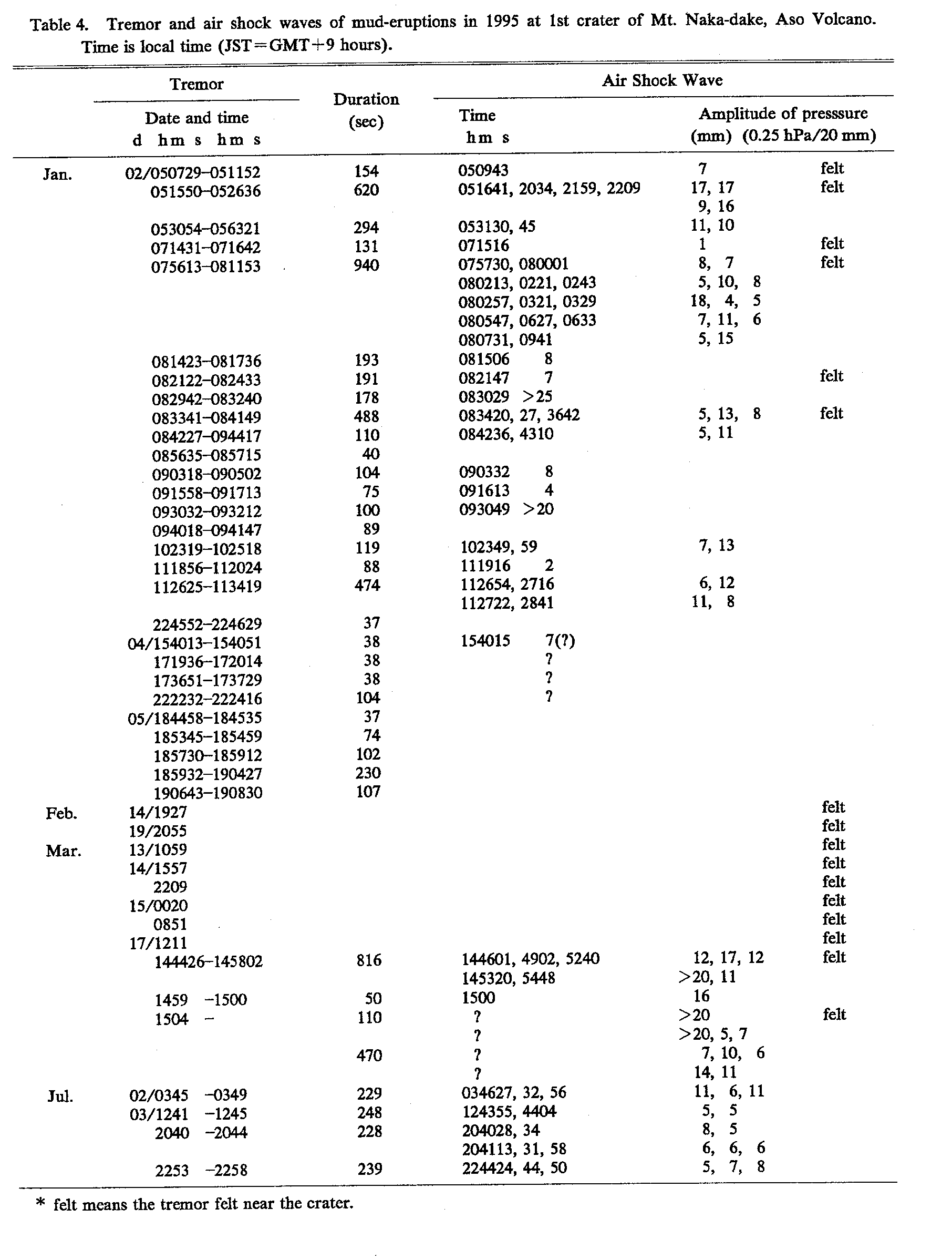
Amplitude of volcanic tremors and volcanic activity: Fig. 13 shows the amplitude variation of volcanic tremors observed at the station SUN about 1 km south from the center of the crater during the period from 1995 to 1998. The amplitude is the maximum value measured every 3 seconds averaging in each 3-days. At Aso volcano, the changes in volcanic tremor amplitude closely correspond to the volcanic activity. In other words, the variation of released energy in the form of volcanic tremors is closely related to the amount of volcanic activity, as observed visually. Therefore Fig. 13 is also an indication of the volcanic activities. The periods when tremor amplitudes are increasing in the figure, are recognized to be the volcanic active stages. For example, the periods, when the amplitudes remained at a large level, of January and July in 1995 many mud eruptions occurred at the crater as shown in Table 4. At the surface of the hot water pool, the events of small sporadic mud spattering were observed. In January 1995, the big mud spattering eruptions occurred with strong rumbling sounds and air shock waves and ejected a great quantity of wet-ashes and head-size block ejection from the 1st crater bottom to the height of about 0.5 km. These spattering eruptions were observed many times until July 1995. In Table 4, these events of mud spattering were listed. Hereafter the amplitude of tremors remained at a low level until now.
Volcanic Earthquake: The activity of volcanic earthquakes was not so strong in 1995-98 as shown in Fig. 12.
Volcanic Tremor: Changes in volcanic tremor amplitudes are closely corresponding to the volcanic activity. In Fig. 13 the amplitude variations of the volcanic tremors are shown each year during the period from 1995 to 1998.
Geomagnetic Total Intensity: The intensity of magnetization is dependent on temperature. In Fig. 14 the variation of the geomagnetic total intensity is shown during the period from 1995 to 1998. At the station S0, from January 1995 to June 1996, the intensity decreased. Then to June 1997, the intensity did not change. After then to March 1998, it increased gradually and the intensity decreased. These changes of geomagnetic intensity were noticeably corresponding to the different stage of the volcanic activity.
(Yasuaki Sudo)
References
**Imura, R. and Kamata, H. (1996) Re-examination of the ancient Literature on activities of Kuju volcano, central Kyushu, Japan. Jour. Geograph., 105, 208-214.
*Shimizu, H., Umakoshi, T. and Matsuwo, N. (1993) Seismic activity in middle and western Kyushu. Mem. Geol. Soc. Japan, 41, 13-18.
*Sudo, Y. (1993) Seismic Activity and Tectonic Significance near the volcanic areas in central Kyushu, Japan. Mem. Geol. Soc. Japan, 41, 19-34.
*Sudo, Y., Okamoto, S., and Tsutsui, T. (1996) Attenuation of Seismic Waves beneath Kuju Volcano. Bull. Volcanol. Soc. Japan, 41, 11-22.
Sudo, Y., Ono, H., Hurst, AW., Tsutsui, T., Mori, T., Nakaboh, M., Matsumoto, Y., Sako, M., Yoshikawa, S., Tanaka, M., Kobayashi.,Y., Hashimoto, T., Hoka, T., Yamada, T., Masuda, H. and Kikuchi, S. (1998) Seismic activity and ground deformation associated with 1995 phreatic eruption of Kuju Volcano, Kyushu, Japan. Jour. Volcanol. Geotherm. Res., 81, 245-267.
*Tada, T. (1993) Crustal deformation in central Kyushu, Japan and its tectonic implication -rifting and spreading of the Beppu-Shimabara Graben-. Mem. Geol. Soc. Japan, 41, 1-12.
(* In Japanese with English abstract. ** In Japanese)