Setsuya Nakada,
Earthquake Research Institute, University of Tokyo
(E-mail: nakada@eri.u-tokyo.ac.jp)Kozo Uto,
Isotope Geoscience Section,Geological Survey of Japan
(E-mail: uto@gsj.go.jp)John C. Eichelberger,
Geophysical Institute, University of Alaska, Fairbanks
(E-mail: eich@gi.alaska.edu)Hiroshi Shimizu,
Graduate School of Science, Kyushu University
(E-mail : shimizu@sevo.kyushu-u.ac.jp)and Sumio Sakuma
Japan Metals and Chemicals, Co. Ltd.
(E-mail: sakuma@geothermal.co.jp)
(Contents)
Summary . 2
1. Introduction . 4
2. Background of Unzen
1) Geology and eruption history . 7
2) Volcanic disaster at Unzen . 9
3. Geophysical signals suggesting the conduit location .11
4. Scientific Drilling Project .11
5. Pre-proposals to ICDP and workshops at Unzen
1) The 1996 workshop .14
2) The 2000 workshop 14
3) Pilot hole for the conduit drilling .16
6. Scientific Approach
1) Structure and magma dynamics .16
2) Degassing problem .18
3) Source volume for precursory geophysical signals .18
7. Scientific Target of Conduit Drilling .19
8. Sample Handling .19
9. Science Plan (Project Management and Science Team) .19
10. References Cited .22
Summary
Volcanic eruptions of felsic magma cause large disasters. More than 50 % of the recent disasters are due to events related to mass flows, such as pyroclastic/debris flows, debris avalanches and tsunamis, the latter resulting from entry of mass flows into the sea or lakes. In more explosive events, volcanic ash and gas cause other serious problems, such as global-scale environmental change and failure of jet engines of airplanes flying over the volcanoes. Although all these events are destructive, they are destructive in different ways. Thus it is vitally important to understand not just when a volcano will erupt, but how it will erupt.
Felsic volcanoes are abundant in island arcs and continental margins, where cities with large populations are concentrated. Unzen Volcano is such a volcano, where a huge volcanic disaster occurred about 200 years ago and the latest eruption occurred in 1990-95. During the latter period, about ten thousand pyroclastic flows were produced due to partial collapses of a growing lava dome, threatening the lives of people around the volcano.
Eruptions of felsic magmas are not always explosive. Three major recent eruptions, Pinatubo in 1991, Mount St. Helens in 1980, and Unzen in 1990-95, were caused by felsic magmas with chemical compositions similar to each other, including similar concentrations of the volatile components that account for explosive activity. However, styles of eruption among the three are very different. Nearly all of PinatuboŽŐs magma was ejected explosively as ash falls and pyroclastic flows. Mount St. HelensŽŐ eruptions began explosively, but produced more and more dome lavas as the episode progressed. Unzen was least explosive, with almost no ash eruptions and with nearly all pyroclastic flows being due to disintegration upon collapse of already extruded lava, not to fragmentation within the conduit. Evidently, a degassing process where the volatile component escapes effectively from magma during its ascent is the major factor controlling whether volcanism is explosive or non-explosive, and hence the kind of damage that an eruption will produce.
The upper part of the magmatic conduit is believed to be the place where most degassing occurs, based upon what is known about the pressure-dependent solubility of volatiles in magma and on the source location of geophysical signals during eruption. Such signals as volcanic tremor may be direct evidence of the degassing process. However, there is much to learn about how so much gas can escape from magma so rapidly. In-situ inspection of the conduit and its wall rock is the most effective approach to understand the mechanism. Scientific drilling at Inyo Domes, at Long Valley Caldera, is the only case to date where a young volcanic conduit was penetrated and sampled, but the 600-year-age of eruption was too old for there to be complementary geophysical monitoring data and the conduit had cooled completely. Despite these limitations, an important model of degassing was proposed, based on the results. The results have been extended by examination of geologic exposures of roots of old lava domes such as Mule Creek Dome in New Mexico, which revealed structures similar to those found in drilling, and by development of numerical models for degassing.
A necessary next step in developing our understanding of the causes of explosive versus non-explosive eruption is to drill into a conduit whose eruptive activity was actually observed. Drilling into the conduit of the latest lava dome at Unzen is a most desirable goal, because the lava that solidified in the conduit is still hot and the location of conduit is well defined by geophysical signals recorded intensively and precisely during eruption. With this challenging scientific project, the combination of direct information on degassing obtained by drilling with geophysical signals obtained during the eruption can solve the problem of eruption mechanisms of felsic magma. In addition, the meanings of geophysical signals can be more correctly interpreted for predicting eruptions and the development of hydrothermal systems after eruption can be elucidated.
Two pre-proposals of Unzen scientific drilling were evaluated by the International Continental Scientific Drilling Program (ICDP). The importance of scientific drilling and the technical problems of drilling itself were discussed in international workshops in 1997 and 2000. Following the first meeting, the Science and Technology Agency of Japan initiated funding of the Unzen Scientific Drilling Project (USDP), as a one-year feasibility study. During the next three years, drilling of two flank holes and one pilot hole for the conduit drilling were completed or are in progress. Questions of the tectonic and magmatic development history of Unzen are being solved through synthesis of geologic data from the surface and the flank holes, and design of the conduit drilling and selection of the drill site has been undertaken. Slant drilling from the northern upper slope of the volcano was found to be an option able to penetrate the conduit above sea level. The permitting process is easier in this site and the cost of drilling is less expensive than a site proposed initially that is within a special area of nature preservation, close to the dome.
It is proposed that conduit drilling will start in 2002 jointly with STA and ICDP, and continue until 2005. Japanese principal investigators are asking STA to defray the major portion of the conduit drilling cost, estimated to be 8.8 MD in total. Fund for a portion of drilling operation (total 3 MD) is requested from ICDP. Foreign scientists, including Co-investigators, will request their own research resources from their respective national science foundations. Five principal investigators have the responsibility of science handling of the conduit drilling, including samples description-partition and logging experiments. Over 60 scientists comprise an international team of the conduit drilling project at Unzen.
1. Introduction
A conduit is the path that takes magma to EarthŽŐs surface. The reason for the existence of volcanic mountains is that conduits are reused, that is, the preferred path of new magma is a previously used path. Though the concept of conduits is familiar, it has become obvious that we cannot understand eruptive behavior until we understand conduits and the processes that occur within them. The clearest distinction among the variety of products of volcanism is whether magma erupts intact as lava or in fragments as ash. The cause of fracturing of magma is internal magmatic vapor pressure that exceeds confining pressure. One reason why it is so important to understand this process is that fragmentation makes volcanism a serious threat to human life and property. Fragmentation transforms magma from a viscous flow of lava to ash that may reach the stratosphere or may rush downhill as pyroclastic flows sweeping away everything in their paths. Impacts are regional or even global.
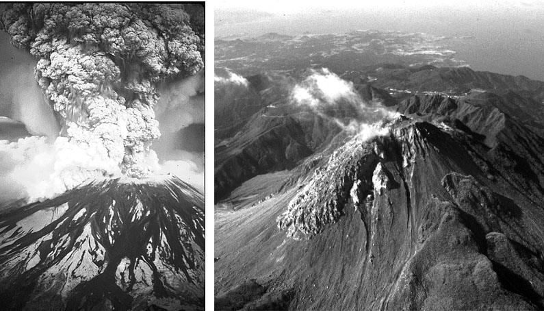
Fig. 1
The two basic kinds of volcanic activity. Left: Explosive as illustrated by the eruption of Mount St. Helens, USA on May 18, 1980. Right: Non-explosive or effusive as illustrated by the eruption of Unzen Volcano, Kyushu, Japan during 1990-1995.Fig.2
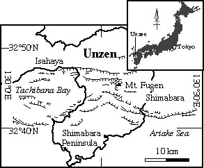
Index map of Shimabara Peninsula in which Unzen volcano locates. Many normal faults characterize an active volcanic graben with the depression axis trending East to West. Mt. Fugen was the highest peak before the latest eruption (1990-95).
The most pressing issue is the degassing of magmas during ascent. An important development of the last two decades has been increasingly robust evidence that silicic magmas commonly contain about 5 wt. % water before eruption (Eichelberger, 1995), an amount far more than that required to cause fragmentation upon decompression to one atmosphere pressure (Sparks, 1978). The time needed for felsic magma to reach the surface and erupt as effusive lava, which has been estimated experimentally based on amphiboleŽŐs break-down due to water loss (Rutherford and Hill, 1993), is a few days or weeks. Coupled with the knowledge of solubility in melt as a function of depth, it must be concluded that most degassing occurs within the final 2 km of magma ascent during eruption. Recognition of these constraints has focused attention on the upper parts of active volcanic conduits.
How does effective degassing occur so quickly in conduits? Degassing by bubble rise is out of the question because of the small size of bubbles and highly viscosity of melt. Simple diffusion of water from the system would be even slower. Eichelberger et al. (1986) suggested that degassing is accomplished by porous flow of vapor from vesiculated magma, and showed that the controlling factors may be ascent rate, gas permeability of wall rock, and conduit size, a conclusion further explored by Jaupart and Allegre (1992). With rapid ascent, magma arrives at the near surface with excess internal vapor pressure and explodes. With slow ascent, the internal gas pressure is bled off by porous flow.
It is time therefore to quantify the characteristics of conduits, as opposed to merely viewing them as a passive pathway from storage chamber to surface deposits. One can look at old systems where erosion has provided a cross section. This can produce a fine 2-dimensional and sometimes 3-dimensional view. However, erosion is a dull knife that does much damage to structures it dissects and the structures viewed are necessarily long dead. On the other hand, if one studies active volcanism where characteristics of eruption are well observed and documented, having the conduit also accessible to inspection is out of the question. The only way to have both the dynamic constraints that eruption observation provide, and knowledge of conduit parameters such as size, physical and thermal structure, and gas permeability, is to drill a volcano that has had a well observed eruption. The challenges for such drilling are that it must be directionally guided and that it must deal with high temperature. These problems have been largely solved by the geothermal energy and minerals industries. What remains is to apply this technology to an active volcano to solve the riddle of explosive versus non-explosive eruption.
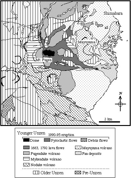
Fig. 3
Geologic map of the eastern half of Unzen volcano (simplified from Hoshizumi et al., 1999). Mayuyama is an old lava dome that collapsed due to big quakes just after an eruption in 1792; a large amount of debris rushed into the sea (to the right), causing Tsunamis that killed 15,000 people living in Shimabara Peninsula and the opposite shore.
The Inyo Domes Scientific Drilling Project was the only previous scientific drilling effort that explicitly targeted a volcanic conduit. Obsidian Dome was extruded following explosive eruption of the Inyo chain of vents about 600 years ago, and has a volume of the same order as UnzenŽŐs new dome. The well successfully penetrated the conduit upon reaching a slant depth of approximately 500 m, continued through the structure which was found to be about 30 m wide, and bottomed in granite basement at about 600 m. The well was cold; no thermal anomaly associated with the conduit remained. The conduit was confirmed to be a dike, even at shallow depth. What Obsidian Dome drilling demonstrated unequivocally was that wet, vesicular magma fed an extrusion of dry, substantially non-vesicular lava. Obviously, both vapor and porosity are lost in the eruption process.
It should be noted that this conduit borehole was oriented solely on the basis of surface geologic data and no correction to the trajectory was made during drilling. Given the much richer database concerning subsurface structure at Unzen together with the ability to drill directionally, the likelihood of successfully intersecting the target should be regarded as very high.
Another of the few previous studies to target volcanic conduits explicitly was the investigation of a Tertiary rhyolite dome, Mule Creek, in New Mexico (Stasiuk et al., 1996). This dome is quite similar to Obsidian Dome in bulk composition, explosive to non-explosive eruption trend, and volume. It exposed to a depth of about 300 m below the pre-eruption surface, and interval shallower than that sampled in the conduit of Obsidian Dome. Although, as at Obsidian Dome, the geologic evidence clearly requires substantial loss of gas over this depth interval during ascent, vesicularity never approaches the critical value that Eichelberger et al. (1986) postulated is required for homogenous porous-flow behavior. Vesicularity reaches a minimum at the glassy margin of the conduit. ŽŇTuffsiteŽÓ dikelets emanate from, but are truncated by the marginal glassy zone, perhaps representing local fragmentation, fracture, and flow of gas-laden magma. The interpretation of Stasiuk et al. (1996) was that this margin represents the site of maximum degassing. They proposed dynamically induced shear-flow degassing, with small domains individually vesiculating and releasing gas ŽĐ sometimes with local in situ fragmentation.
A problem with both Obsidian Dome and Mule Creek investigations is distinguishing those features developed in wallrock during the explosive phase rather than the later effusive phase. The conduit must have been greatly overpressured during the explosive phase, quite in contrast to conditions that developed later during the effusive phase. Unzen is an especially propitious site for studying effusive eruption because its eruption was entirely effusive. Not only can we expect to see fresher, younger, thermally and chemically active features of conduits in the case of Unzen drilling, but for the first time we can look at structures that are unequivocally known to result from effusive behavior.
2. Background of Unzen
1) Geology and eruption history of Unzen
Unzen, a compound volcano of andesite to dacite, has developed in an active east-west trending graben that has opened by north-south extension since about 500 ka (Figs. 2 and 3) (Hoshizumi et al., 1999). Geodetic data indicate continuing vigor of graben movement, with rates of lateral extension of 4 mm/y and subsidence at 2mm/y. Analysis of existing geothermal exploration wells and water/hot spring wells shows that the deepest part of the graben, about 1 km below the sea level, is in the center (Fig. 4). The volcano is composed of thick lava flows and domes, together with the products of their collapse (pyroclastic flow and debris flow deposits), from two activity stages. The younger stage started ca. 100 ka following a dormant period after the older stage. Three historic eruptions are documented during the last three hundred years, producing andesite to dacite lava flows and a lava dome.
The latest eruption started in 1990 and ended in 1995 near the old summit of Mt. Unzen, forming a large dacite lava dome and a new summit. In total, 200 million cubic meters of magma effused in this eruption (Nakada et al., 1999). Half of this volume remained intact as a composite dome, while partial collapses resulted in generation of approximately 10,000 pyroclastic flows. Each cascaded violently eastward toward a residential area and the city of Shimabara. In addition, heavy rains mobilized debris flows from the vast field of pyroclastic flow deposits and destroyed more housing. A suburban to urban area of ~ 10 km2 was buried with pyroclastic flow and debris flow deposits.
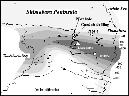
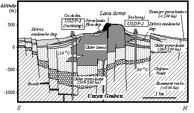
Fig. 4
Map showing bottom depth of the Unzen Volcanic Graben (Hoshizumi et al., 1999). The lowest central axis runs in the east to west direction. Drilling at USDP-1 and -2 aimed or is aiming at the bottom in the periphery and axis of the graben, respectively. Dots represent well locations.
2) Volcanic disaster at Unzen
Although recent activity at Unzen Volcano is characterized by simple effusion of andesite to dacite lavas from the summit, partial collapses of growing domes and an old dome generated tragic events. In 1792, a large prehistoric lava dome located between Unzen and densely populated Shimabara City, collapsed in an earthquake that immediately followed a summit eruption. Masses of debris (~0.3 km3) rushed into the inland sea, generating a big tsunami. This tsunami event killed 15,000 people around the volcano and on the opposite shore. This is the fifth worst volcanic disaster on record in the world, and the worst one in Japan. In the latest eruption (1990-1995), pyroclastic flows killed 44 people including French and American scientists and Japanese journalists. They were taking photographs and movies of the onrushing pyroclastic clouds. In total, $2 billion-worth of property was claimed by the latest eruption. UNESCO designated Unzen as one of the DECADE volcanoes of the International Decade of Natural Disaster Reduction (IDNDR) in 1991.
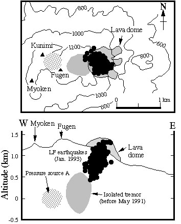
Fig. 5
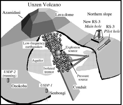
Plain view and vertical section of the summit area in Unzen volcano, showing a hypocenter region of isolated tremor that occurred before May 1991, and hypocenters of low-frequency (LF) earthquakes in January 1993 (solid circles) (after Nakada et al., 1999). One of three pressure sources explaining volcanoŽŐs deformation during the 1990-95 eruption is also shown; the shallowest and smallest one (source A) (Hendrasto et al., 1997). A simplified outline of the early 1993 dome was also drawn. These hypocenters may represent the location of a conduit inclining westward, which passes close to the pressure source A.Fig. 6
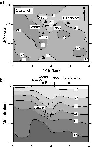
Seismic tomography below the summit area of Unzen volcano (Nishi et al., 2000, unpublished). Inversion was carried out using the result of a seismic experiment in 1995. Numbers represent seismic velocity (P wave) in km/s. Plain view at the seal level (a) clearly indicates the low velocity region east of the summit, probably representing the conduit (b). The region is the same as the site of the shallowest pressure source, A (Fig. 5).
3. Geophysical Signals Suggesting the Conduit Location
Geophysical signals such as seismic activity and ground deformation are always associated by magmaŽŐs migration in a conduit and approach to the surface. Before and during the latest eruption at Unzen volcano, swarms of volcano-tectonic earthquakes and low frequency earthquakes were monitored together with volcanoŽŐs inflation and deflation (summary of Nakada et al., 1999). Volcano-tectonic earthquakes migrated from depth and from west of the volcano toward the summit, where eruption then started. Isolated tremor events occurred at 2-0.5 km depth, and low-frequency earthquake events occurred at 0.5-0 km depth (Fig. 5). The hypocenter regions are deeper westward from the lava dome. As these seismic signals are thought to reflect magmatic processes such as vesiculation and fragmentation, magma interaction with groundwater, and escape of volatiles from magma, the location of the events represents the location of conduit. A magnetotelluric survey during the eruption revealed the existence of a low resistive layer at 0.5-1 km depth, representing a water-saturated condition (Kagiyama et al., 1999). The depth level is the same as the region of generation of volcanic tremor event.
Deformation-and-inflation detected by GPS and ground leveling surveys can be explained by multiple pressure sources under the volcano. They are located approximately 11, 6.8, 4.1 and 1.4 km below the surface, deeper westward from the summit (Nishi et al., 1999, Hendrasto et al., 1997) (Fig. 6). Small-scale explosions that occurred in the initial stage of eruption (explosion earthquakes and summit inflation) also gave the information on the location of magmaŽŐs storage (Shimizu et al., 1992). The analysis on ground deformation associated with two explosions yields the explosion source 0.6-0.9 km below the crater with a diameter of about 40 m, assuming a sphere.
Recent seismic tomography indicated a low-velocity anomaly at about sea level beneath the summit, also suggesting the location of conduit. The anomaly region is a little west of the isolated tremor region, but is very close to the site for the shallowest pressure source (Fig. 6).
4. Scientific Drilling Project
The Science and Technology Agency (STA) of Japan initiated the Unzen Scientific Drilling Project (USDP) in April 1999, following a one-year feasibility study. It is scheduled as a six-year project, consisting of two phases. The project first aims at clarifying the growth history and magmatic evolution of Unzen with two holes drilled into the volcanoŽŐs flank, reaching the volcanic basement. The second phase is evaluation of the eruption process and modeling of the eruption mechanism by drilling into the conduit of the 1990-95 eruption. Conduit drilling in the second phase is proposed as a joint research project with ICDP. Detailed design of conduit drilling, both scientifically and technically, has been discussed as part of the work of the first phase of the project. Negotiations with Environment and Forest agencies, and explanation of the project to local people, are also being done during the first phase. A one-year-long environmental assessment around the possible drilling sites was carried out.
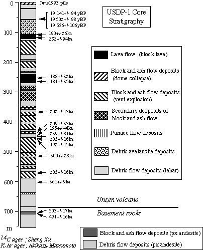
Results from the two holes (750 and 1,400 m deep) into northeastern and eastern flanks of Unzen are revealing its subsurface structure and growth history (Figs. 7 and 8). The first, northeastern flank drilling achieved a core recovery of more than 90%. Many layers of pyroclastic flows were encountered (Fig. 7). The oldest pyroclastic material includes vesiculated pumice that is rarely found on the modern surface. The base of the Unzen products appears at about 680 m below the surface, and pyroxene andesite of 0.5 Ma was recovered beneath it. Systematic K-Ar dating of the juvenile lava blocks in cores revealed that pyroclastic deposits between -250 m and -630 m depth were accumulated in a relatively a short period from 0.19 - 0.26 Ma. Only very small amount of products of the early eruptions of 0.5-0.26 Ma reached this drill site. The above information may suggest that graben formation accelerated after about 0.25 Ma, and was associated with intensification of volcanism. The second flank drilling started in late September, 2000 at the eastern foot of the volcano where recent pyroclastic flows have repeatedly reached. The drilling will be continued until the summer of 2001to a depth of about 1,400 m beneath the surface.
Fig. 7
Lithological variation of USDP-1 drilled in 1999-2000. K-Ar and 14C age determination results represent deposition of the major part here in a short period around 200 ka.Fig.8
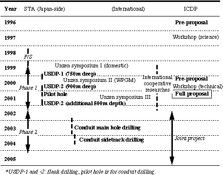
Schematic cartoon showing S-N geologic section of the Unzen Volcanic Graben. Results from flank drilling at two sites (USDP-1 and ŽĐ2) are shown.Table 1. Time table of the USDP
5. Pre-proposals to ICDP and workshops at Unzen
Preliminary proposals for scientific drilling into the conduit of the 1991-95 dome at Unzen were evaluated in 1996 and 2000 (Table 1). S. Nakada and J. C. Eichelberger submitted the first pre-proposal of ŽŇSubsurface exploration of Unzen, Decade Volcano: Scientific drilling for hazard mitigationŽÓ. The second pre-proposal, ŽŇ Unzen Scientific Drilling Project (USDP): Intersecting a high-temperature volcanic conduitŽÓ, was submitted by S. Nakada, J.C. Eichelberger, K. Uto and H. Shimizu to support a workshop on technical issues of drilling that the first workshop identified.
The two international ICDP-sponsored workshops were held in Shimabara near Unzen Volcano. The first workshop affirmed the basic concept of the project, and the second one spurred us to proceed with conduit drilling.
1) The 1997 workshop
The first workshop was a scientific meeting held in May 1997. In this workshop, the importance of the latest eruption and scientific drilling was stressed. Seventy-five scientists, including 14 from outside Japan, joined the meeting. Discussions emphasized the critical role of conditions in the upper conduit in controlling whether eruptions are explosive or effusive. Results were summarized as a report to Eos, published by the American Geophysical Union (ŽŇResearchers Discuss Mt. Unzen, a Decade VolcanoŽÓ by S. Nakada, J.C. Eichelberger and H. Shimizu; Volume 78, p. 505-507, 1997), and as a special issue of the Journal of Volcanology and Geothermal Research (Elsevier) (ŽŇUnzen Eruption: Magma Ascent and Dome GrowthŽÓ, edited by S. Nakada, J.C. Eichelberger and H. Shimizu; volume 89, 315p. 1999).
Following results of discussions of the first international workshop, and recognizing the need for additional geological data and research on engineering and environmental issues prior to attempting to reach the conduit, Japanese scientists started preparation of a domestic project on Unzen volcano involving scientific drilling (USDP). K. Uto, Geological Survey of Japan, organized the scientists and, as the project leader, proposed the drilling project to Science and Technology Agency, Japan (STA). In the first phase of the USDP project, preparation of conduit drilling started, including drilling site, drilling method, logistics, permitting, and so on. During this process, a world-wide survey of techniques applicable to conduit drilling was needed promptly. To accomplish this, a second preproposal to the ICDP was submitted in January 2000.
2) The 2000 workshop
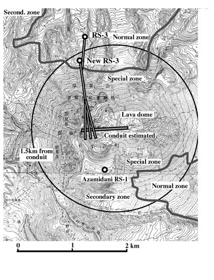
The second workshop, Unzen Scientific International Drilling Workshop (USIDW) held in October 2000, focused on drilling techniques. Conduit drilling is aimed at the upper part of the conduit located just beneath the summit of the volcano. The summit area has an extremely rugged surface and no water. The estimated temperature within the conduit is over 600 ŽˇC. During the feasibility study supported by STA in 1998, we selected four candidate sites from which we could penetrate the upper part of the conduit. The best place from the scientific point of view is located at Azamidani (RS-1), closest to the summit of Mt. Unzen. But in that area, nature preservation restrictions are strongest. Although our dialog with officials of environment and forest agencies and local governments conducted in mid 1999 to early 2000 were very positive, it was clear that gettingˇˇpermission for the Azamidani site would be difficult, if not impossible. The location is too close to popular tourist spots and the access was the worst of all possible sites, such that either use of a helicopter or installation of an aerial tramway would be required. Furthermore, the result of our environmental assessment in the area in 2000 showed the existence of many important species of animals and plants. Therefore, alternative drilling sites for conduit drilling and applicable drilling techniques were discussed in the workshop.
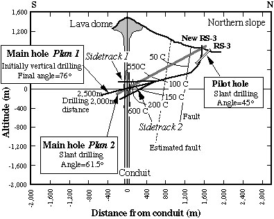
Three groups (Alpexplo, Devico-NED-JMC, and DOSECC-Dynatec) presented proposed plans (drilling site and method, and casing plan) for achieving the scientific targets, based on parameters of conduit drilling provided to them prior to the meeting. Though the three groups initially favored three different drilling sites, a clear consensus developed in the course of discussion that the northern slope of the volcano (new RS-3; Fig. 9) is the best choice. Getting permission for drilling in this site is much easier than at RS-1, and drilling there will be less expensive due to access by road, eliminating need for a helicopter or an aerial tramway. Despite the greater distance from the target, with current technology, slant drilling from this site can penetrate the conduit at a depth shallower than sea level, and recover the cores around the conduit (Figs. 10 and 11). Because the edifice as a whole is a cold hydrologic recharge area and the hot conduit should be narrow along the direction of penetration, the temperature of mud circulation is expected to be less than 200 ŽˇC.
Fig.9
Topographic map of the summit area of Unzen volcano, showing the drilling sites for main (new RS-3) and pilot (RS-3) conduit holes. RS-1 (Azamidani) that locates in the special zone of nature preservation is the site proposed before the international technical workshop in October 2000. Conduit inclines westward from the lava dome.Fig. 10
3D image of USDP. ŽŇPressure sourceŽÓ is the source A of Hendrasto et al., (1997) (at sea level). ŽŇExplosion sourceŽÓ is the pressure source for the Vulcanian eruptions (500 m a.s.l., Shimizu, 1992).
3) Pilot hole for the conduit drilling
The importance of drilling a pilot hole was emphasized in the second workshop. Knowledge of the geological structure and water condition near the mouth of the conduit hole is critical to designing the drilling strategy and preparing detailed drilling plans. The hole can be also used for re-injection of spent drilling fluid during conduit drilling.
In consequence and in response to an application that we submitted immediately following the second workshop, STA decided to fund a pilot conduit hole. Around 400-m in slant drilling has been scheduled at RS-3 in January to March 2001 (Figs. 9-11).
6. Scientific Approach
1) Structure and magma dynamics
As already mentioned, a constraint on size of conduits is very important to understanding magmatic behavior and the forces driving ascent. Though measurements of the Unzen dome during eruption yield mass flux from the volcano with time (Nakada et al., 1999), the rate of magma ascent is unknown because of no knowledge on the dimension of the conduit. In addition, an important clue to why conduits are reused will be contained in the relationship of UnzenŽŐs 1990-1995 conduit to those that fed earlier eruptions. For example, successive conduits may be found to be concentrically nested (new intrusion follows centerline of previous intrusion) or simply bundled (new intrusion follows wallrock contact of previous intrusion) in the underlying basement. There may also be evidence regarding the evolution of the conduit with time. Relationships suggesting wall rock erosion during growth of the conduit an/or shrinkage of the flow regime by stagnation of marginal zones will provide evidence of the dynamic interplay among driving force, advective heat transport into, and heat loss from the system.
Proper identification of the 1990-1995 conduit will of course be a prerequisite for success. The youngest conduit will be filled with massive dacite that will be more coarsely crystalline and more regularly flow banded than dome lava because of its emplacement at depth as an intrusion. It will be fresher than earlier conduits because it has been exposed to hydrothermal alteration for only a few years. We should also anticipate that the physical structure will coincide with the thermal structure. As the next youngest conduit was emplaced two centuries ago and therefore be mostly or completely cooled, the temperature maximum in the borehole will coincide with the center of the youngest conduit.
Possible trajectories of main conduit holes drilled from the northern slope of Mount Unzen. Trajectory of pilot hole drilled in January-March 2001 is also illustrated.
2) Degassing problem
How the gas leaves the system so rapidly and efficiently as to permit non-explosive eruption of magma is the most important problem. So much gas must be released that we should expect to see some evidence of how it flowed. This might be immediately obvious, as chemically leached fracture zones, perhaps even lined with vapor-deposited crystals. Or, it may be more subtle, for example revealed through exploration of distribution of oxygen and hydrogen isotopic compositions of the samples. An important parameter that has never been measured is gas permeability in the region of the conduit of an active volcano. The relationship of this observation to the degassing problem is obvious. If permeability is found to be very high, then we have a ready explanation for why Unzen magmas erupt non-explosively. Future research might complement this finding with a search for low permeabilities near the conduits of explosive volcanoes. If gas permeabilities are low, then we most look to some other mechanism, presumably related to initiation of conduit flow, to allow gas release.
A number of related questions must also be answered. What is the temperature field inside the volcano, which will govern initial conductive heat loss of rising magma; what are the hydrologic conditions, which will govern convective heat loss and opportunities for precursory phreatic activity; and what is the strength of the rock that must be broken for the magma to reach the surface? It is remarkable that we seem to see so little relationship between repose period and eruptive behavior. Do conditions in the edifice really not matter to the behavior of subsequent intrusions? Or is the return to the repose state so rapid that most new events encounter the same conditions? Unzen drilling will help to answer these questions by revealing conditions immediately after the end of an eruptive cycle.
3) Source volume for precursory geophysical signals
A related but more immediately practical motivation for assessing the parameters of the subvolcanic environment is interpreting precursory geophysical activity. The Unzen eruption is an exemplary case of modern volcanological monitoring methods accurately tracking the rise of magma into a dormant volcano, leading to warnings on a time scale that saved many lives. As in the case of most other eruptions, the signs of imminent activity were intensifying seismic swarms immediately beneath the vent and accelerating rates of surface deformation. Proper interpretation of these signals would be much enhanced by knowing the conditions under which they are generated. Is the seismicity induced by release of vapor from the magma and opening fractures in the surrounding formation (e.g., Chouet et al, 1994)? May there be actual structures, such as pyroclastic dikes that can be recognized within the seismically illuminated volume as the source of this seismicity (e.g., Stasiuk et al, 1996)? What of the inflation source? This is modeled at a Mogi point source but can we discover whether it is entirely accounted for by conduit growth? Or is it too due to the pumping of fluids out into the edifice formation, or fragmental dikes, or even injection of dikelets of intact magma? What are the physical and chemical characteristics of the source region of the Vulcanian explosions? In addition, simply by having direct measurements of rock properties such as seismic velocity, density, and electrical conductivity at depth, it will be possible to improve modeling of surface geophysical data in interpreting the subsurface structure.
The goal of conduit drilling should be viewed as more than just testing currently held ideas. It may well lead the way to successful modeling of conduits as dynamic features that develop, mature, and die during an eruption cycle.
7. Scientific Target of Conduit Drilling
To understand magmatic processes in the upper conduit, we describe the scientific objectives as follows:
Logging
(1) Temperature log is important to know the thermal profile around the conduit and its cooling history after eruption. Temperature measurement while drilling is also indispensable to detect the intersection with the hot conduit. (2) Tele-viewer images help to understand the 3D-structures both outside and inside the conduit. (3) Sonic velocity log is critical to re-analyze the hypocenters of earthquakes during eruption and their mechanism. (4) Density and porosity logging are important to understand the permeability of the country rock and conduit-filling intrusion itself. (5) Resistivity measurements tell us the location of water, revealing its important role of magmatic interaction in generating precursory explosions and conduit opening, and in cooling the conduit during and after eruption.
8. Sample Handling
Basic descriptions of cores and logs will be carried out, led by the principal investigators. Details of core sample allocation and access to bore holes will also be decided by the PIs. Samples will be first examined in detail near the drill site, at Shimabara Earthquake and Volcano Observatory, Kyushu University, by the on-site science team of the University of Tokyo and Geological Survey of Japan, then transferred to Tokyo and stored in the University of Tokyo. Scientists from the University of Alaska will join in describing and sampling the core for initial petrological characterization at the University of Tokyo. Samples will be distributed from the University of Tokyo upon scientific requests. Archival records of cores, logging, and analysis will be made available to outside investigators using the Data Information System of GFZ.
9. Science Plan (Project Management and Science Team)
The principal investigators of the USDP are S. Nakada (Univ. Tokyo), K. Uto (Geol. Surv. Japan), J. Eichelberger (Univ. Alaska), H. Shimizu (Kyushu Univ.) and S. Sakuma (Japan Metals and Chemicals) (Table. 1). These PIs and their Co-investigators have each organized a science team. In total, over 60 scientists are participating in various aspects of the USDP, though not all are listed by name in this proposal.
Total costs needed for drilling operation, including main conduit holes, sidetracks and construction of access road, are estimated to be 8.8 USD (Tables 3 and 4). The major portion will be covered by Japanese Government funds (about 2/3 of total). Here, we asked ICDPŽŐs defray about 1/3 of total (Table 3). Travel expenses of foreign scientists and research on samples back in their own countries should be defrayed by their respective science funding agencies.
Table 2 Scientists Participating in USDP
Table 4 Cost estimation for conduit drilling
10. References Cited