Purpose of this proposal
We request support for a technical workshop to bring together international drilling experts and volcanologists for the purpose of developing a plan to drill into the volcanic conduit of Unzen Volcano. As this project represents the first attempt to directly access the conduit of a recently active volcano, it poses major engineering challenges, while holding the promise of many scientific rewards. Although the goal is unprecedented, the elements necessary to achieve it - high temperature drilling, coring and logging in volcanic systems, directional drilling to intersect a volcanic conduit, and minimization of site impact in environmentally sensitive areas have been successfully addressed by projects elsewhere. Therefore, we wish to bring together people with the appropriate experience to formulate a drilling plan that will maximize scientific return while minimizing cost and impact. Products will be a report of the deliberations immediately following the meeting for publication in Eos or similar science-news type journals and, by year's end, a drilling plan upon which the proposal to ICDP and Japanese agencies will be based.
1. Introduction
A volcanic conduit is the pathway by which magma reaches the surface. Volcanic mountains exist because preferred pathways exist. Indeed, magma has the remarkable ability to follow the same or nearly the same course through solid rock over and over again. This journey begins, for the parental magmas of subduction zone volcanoes, at some 100-km depth. However, it is the final 1 to 2 km of the pathway that is of the most immediate interest. It is here that the extent of magma degassing determines whether an eruption will be explosive - producing ash falls and pyroclastic flows - or effusive - producing only lava. How processes occurring at shallow depth in conduits control eruptive behavior is one of the fundamental questions of volcanology. It is also here that the geophysical signals of imminent eruption arise. All over the world, interpretation of shallow seismicity beneath volcanoes and deformation at the surface are being used to warn of eruptions. The proper interpretation of these signals may be a matter of life and death significance to thousands of people living on or near a restless volcano. It is therefore vitally important that we work to improve our ability to interpret the signals of unrest, and also that we begin to develop the capability to predict whether or not an eruption will be explosive. What is needed is drilling observation and sampling of the conduit of a well-understood volcano, shortly after a closely monitored eruption has ceased. The questions to be addressed are the structure of the conduit, the temperature field around the conduit, the fracture and matrix permeability around the conduit, the fluid environment, and the other physical properties of the conduit and its surroundings.
Our goal is to intersect, sample, and observe the still-hot pipe, or more likely dike, that fed the 1990-95 eruption of Unzen Volcano (Figure 1). The reasons for the choice of this site at this time have been previously elaborated. Briefly, Unzen is a representative of an important class of volcanoes that has caused much death and destruction in the 20th century, and will continue to do so in the next. Unzen itself did $2 billion damage, caused more than ten thousands of people to leave their homes, and ended 44 lives during its recent eruption. The 1792 eruption event triggered a large-scale collapse of an old volcanic dome, resulting in death of 15,000 people around the volcano. The volcano has already become the focus of international volcanological attention through its designation as a Decade Volcano by the International Association of Volcanology and Chemistry of EarthŽŐs Interior (IAVCEI) and the focus of a national research drilling program to understand its history and structure. Its highly accessible location in a technologically advanced country makes it a favorable place to attempt an engineering goal that has not been previously attempted. It is proposed that this attempt should become the international second phase of the current national drilling effort.
2. Background and the present state of the project
2-1. 1996 pre-proposal and 1997 Unzen workshop
A preliminary proposal of "Subsurface exploration of Unzen, Decade Volcano: Scientific Drilling for Hazard Mitigation" was submitted to ICDP by S. Nakada and J. C. Eichelberger in April 1996 (Table 1). This preliminary preproposal was accepted and ICDP funds were provided for an international scientific workshop. "Unzen International Workshop: Decade Volcano and Scientific Drilling" was held in Shimabara at the foot of Unzen Volcano in May 26-29, 1997. It was co-sponsored by ICDP, the Earthquake Research Institute (University of Tokyo), and the National Committee of Volcanology (Science Council of Japan), and supported by both Shimabara City and the Volcanological Society of Japan. About 75 scientists from seven countries attended the meeting, discussed scientific results from monitoring of the eruption, and formulated objectives for the scientific drilling project. A summary of the meeting was published in both Eos (Vol. 78, 505-507, 1997) and Bull. Volcanol. Soc. Japan (Vol. 42, 239-244, 1997). A major product was publication of a special volume, "Unzen eruption: Magma ascent and dome growth" in Journal of Volcanology and Geothermal Research (vol. 89, Nos. 1-4, 315pp) by Elsevier in April 1999. The conference demonstrated the broad international scientific interest in Unzen Volcano, but also illuminated the need for additional technical investigations and discussions in order to develop a drilling program.
2-2. STA project (Unzen Scientific Drilling Project)
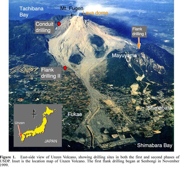
The Unzen workshop led Japanese scientists to develop a concrete plan for a scientific drilling project within Japan. It was decided to apply for a national project for Science Promotion to the Science Technology Agency (STA), "Unzen Volcano: International cooperative research with scientific drilling, for understanding eruption mechanisms and magmatic activity". The proposal was accepted by STA in early 1998, and a feasibility study was begun in April 1998. During this period, scientists continued evaluation of the possible drilling sites and discussing scientific goals of the project. As a result of the feasibility study, a revised proposal was submitted to STA and this too was accepted. The Unzen Science Drilling Project started officially in April 1999. The project consists of two phases. The first phase (3 years) consists of drilling two boreholes into the flanks of Unzen Volcano and conducting associated research. The second phase (3 years) is drilling into the conduit. The second phase would depend upon a favorable scientific review of the first phase (Table 1). However, money support outside Japan is needed to complete the scientific goals in the second phase.
The first flank well aims at 750-m depth and was started at the Senbongi district in the western part of Shimabara City in November 1999. After logging, this borehole will be used for geophysical monitoring of future eruptions. The second flank well, to be sited in Fukae Town (Figure 1), will reach 1500-m depth. The research group concerned with the conduit drilling in the second phase started its activity in May 1999. The blue print of conduit drilling, drilling logistics and technical problems were discussed, there, and GFZ scientists participated in the third meeting in early November 1999. Another topic of discussion was holding an international workshop on technological aspects of drilling into a high-temperature volcanic intrusion - the objective of this proposal. Environmental assessment around the drilling site (Azamidani) began in January 2000.
2-3. International cooperation
International cooperative studies including petrological high-pressure experiments and isotopic geochemistry have started with German and Chinese scientists in the first phase. US scientists are planning to join geological and petrological study of cores from the flank wells. The Data-information-system (DIS) developed by GFZ has been tested to describe the drilling cores and record logging data in the first phase. Also, logging of the borehole in both the first and second phases is prepared as a cooperative research with GFZ; being proposed as a separate proposal to ICDP by the latter. It is envisioned that the conduit drilling will be done jointly by ICDP and STA. (Table 1).
3. Design of conduit drilling
3-1. Scientific targets
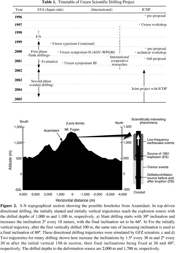
We know that conduits must be a domain of rapid upward change from the near-equilibrium, high pressure and temperature domain of the magma reservoir to the extreme disequilibrium conditions and accompanying rapid mass and heat transfer at the surface. In its last kilometer of ascent, the multiphase (liquid, gas, solid) fluid that is magma is subjected to an order of magnitude decrease in solubility of water in melt with more than an order of magnitude increase in melt viscosity, more than two orders of magnitude decrease in vapor density, and the onset of crystal growth. This in turn causes huge changes in magmatic properties and is responsible for a number of geophysical phenomena and signals just prior to and during eruption. The second phase of USDP targets the upper part of the conduit through which the lava dome of the 1991-1995 eruption emerged. Physical phenomena or signals observed during eruption were isolated tremor events (1.5-0.5 km deep), low-frequency earthquake events (0.5-0 km), sources of vulcanian explosions and deformation-and-inflation in 1.2 and 0.5 km-depths, respectively (Figure 2). These phenomena and signals are thought to reflect magmatic degassing during ascent and also interaction of magma with groundwater in an aquifer below 0.5-km depth. Direct drilling into the conduit in this depth range level is critical in order to verify interpretation of monitoring data during eruptions and to understand these important magmatic processes.
1) Rock and fluid sampling: Continuous coring in and around the conduit (at least through an interval several hundred meters long and including conduit) is essential to understand the magmatic and hydrothermal processes of the conduit. The rock samples will be used not only for geochemical and petrological purposes but also for geophysical purposes including rock mechanics investigations relevant to volcanic earthquake source mechanisms and to the dynamics of magma intrusion. Sampling the present fluids in or around the conduit provides information concerning the chemical budget in the conduit area during and after eruption as well as the role of hydrothermal circulation in cooling the conduit.
2) Measurements using the borehole: Distributions of seismic velocity, resistivity, stress pattern and temperature throughout the borehole are important to analyze physical structures around the upper part of the conduit. Images (FMI and BHTV) and physical parameters (in-situ density, porosity and permeability) of materials in and around the conduit are essential to address the magmatic degassing and hydrothermal circulation phenomena quantitatively.
3) Long-term observation and monitoring: The borehole will be used for geophysical monitoring of future eruptions by installing seismometers and tilt-meters.
3-2. Site selection
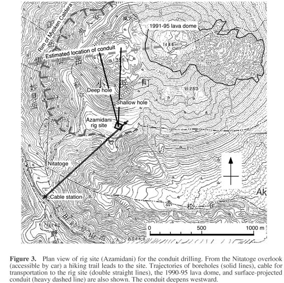
The rig site for conduit drilling was selected in order to reach relatively shallow parts of the conduit, including the vicinity of the vulcanian explosion source, with top-driven directional drilling (Figures 2 and 3). This selection took into account logistical considerations, including sufficient flat space (50x60 m), easy access and ability to supply water to the site. Drilling with a rotary system is another option, allowing measurements while drilling (MWD), and in this case we can reach the deeper target, the deformation source. The selected site lies on a depression just inside the rim of a caldera formed about 20 ka, and on the southern slope the summit lava dome formed about 8 ka. A narrow hiking trail, closed to the public since the eruption, leads to the site from the closest parking lot (Nitatoge overlook). Access to the site for installation of equipment and transportation of drilling supplies will require construction of a cable from the side of the public road to the site (Figure 3). Using a helicopter is another option, but it would be more expensive, more disturbing to park visitors, and less reliable in bad weather. Water will be pumped up to the parking lot, stored in a large tank, and transferred to the drilling site by a pipeline along the hiking trail.
The rig site is in a special area of nature preservation of Unzen National Park. According to the Environment Agency, any activity to modify the land and distribution of living things (animals and plants) is limited to scientific purposes and must be carried out at the smallest possible scale. In addition, permission from the Environment Agency, Agency of Culture Affairs, Forestry Agency, Park Office and Hot-spring Association of the prefecture government are needed.
3-3. Physical structure around the conduit
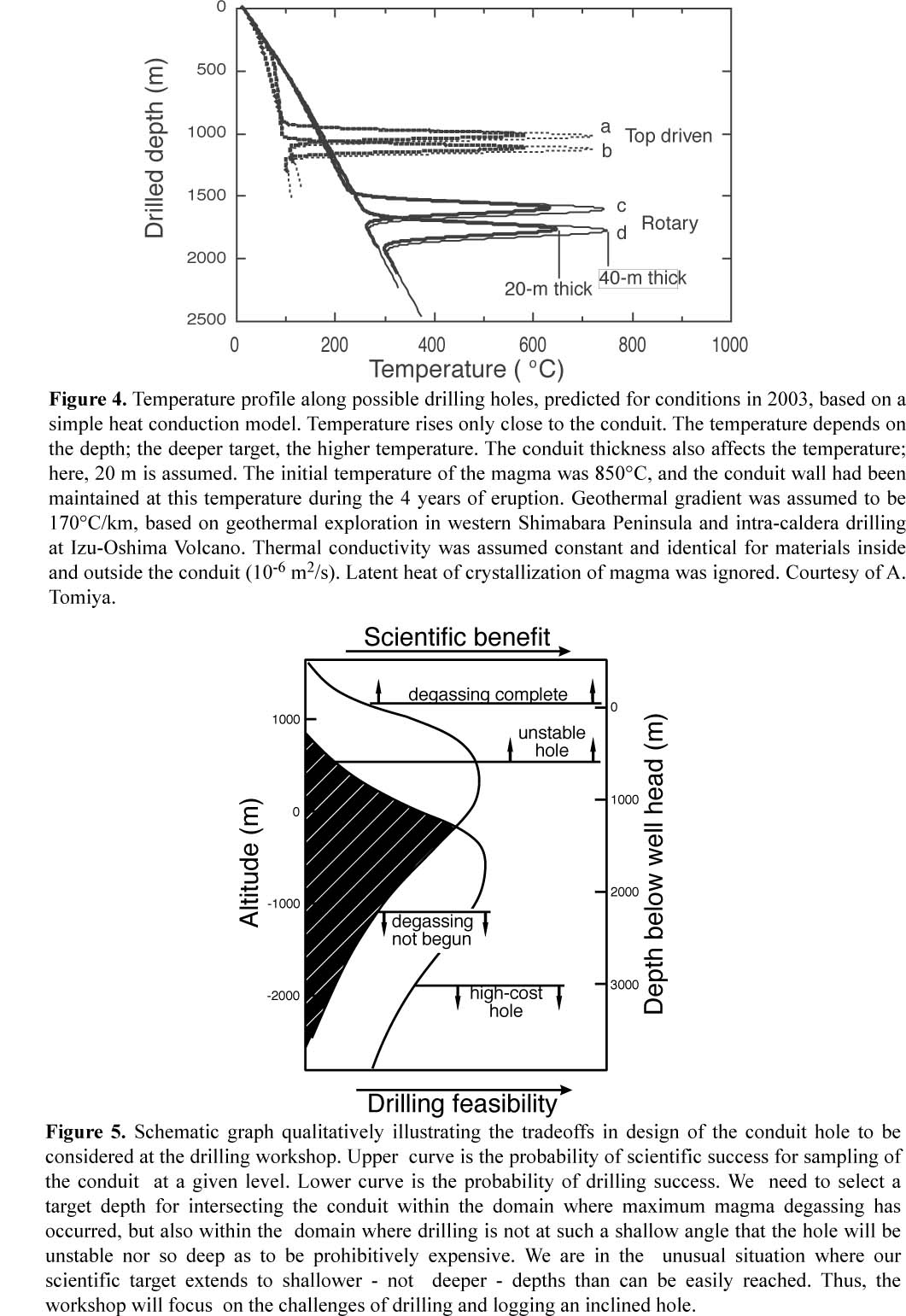
The conduit is thought to be E-W-trending plate with a N-S thickness up to a few tens of meter and an E-W width of a 100 m or more. Drilling is planned to penetrate the conduit from the south. Estimation of the temperature profile through the conduit is very critical to this project. Based on a simple conductive model, the temperature profile in 2003, when the conduit drilling is anticipated, was calculated (Figure 4). The wall rocks of the conduit had been heated by magma with the temperature of 850ŽˇC during the four-year eruption. For a conduit that is 20 m thick, this heating effect is limited to wall rock less than 100 m laterally from the conduit center. Temperature in the conduit depends largely on thickness and depth of interest. Top-driven directional drilling reaches the conduit at more than 500ŽˇC, while the deeper rotary drilling at more than 600ŽˇC. In the case of 40-m-thick conduit, the temperature of the conduit center increases by about 100ŽˇC respectively. With latent heat of crystallization being taken into consideration, these maximum temperatures increase by approximately 100ŽˇC. However, the assumption that cooling is by conduction alone makes these estimated temperatures upper limits. Circulation of water fluid around the volcanic conduit should act as an effective coolant of rock, just as it does in a borehole.
3-4. Difficulties of the conduit drilling
The conduit drilling poses several difficulties, including temperature, logistics, precise targeting, and permitting of drilling.
1) Heat: Use of a mud cooling system will make it possible to continue drilling into the conduit and wall rock in this environment. Technology employed in the high temperature drilling in Kakkonda, Japan may be applicable here.
2) Unconsolidated materials: Because the near-surface is dominated by loose materials, initiating directional drilling to aim a shallow target will require special techniques and rig-site design to avoid hole-wall collapse, lost circulation, and stuck pipe.
3) Access: The size of the cable depends on the size of the largest item of drilling equipment that must be transferred. As water should be supplied from distant place using pipe lines and/or water tanks, re-use of drilling fluid after it passes through a mud-cooling system during the conduit drilling is a necessity.
4) Targeting: The explosion source, deformation source, and low-frequency earthquake regions are believed to delineate the conduit position. However, errors in their positioning are not smaller than several hundred meters both laterally and vertically. Precise re-estimation of the conduit location is needed before conduit drilling. A seismic experiment focusing only on the summit area is scheduled to determine the precise location of the drilling target for USDP in 2001. Also, a variety of deformation source models will be evaluated.
5) Environmental protection: An environmental assessment of the impact of the project is a prerequisite to get the permission from environmental and cultural agencies. This needs to be early in the first phase. As the present research may be unfamiliar to them, an extensive dialog between scientists and agency officials will be necessary.
There needs to be continued debate about the depth at which the conduit should be intersected, as shown schematically in Figure 5. The answer has both engineering and scientific components. The more shallowly inclined the hole the shorter the route to the conduit. However, a shallow inclination reduces stability of the hole and increases difficulties in moving logging tools and other devices within it. A steeper hole requires more drilling. But, more seriously, a steeper hole might intersect the conduit at a level deeper than scientifically desirable. Scientifically, if we intersect the conduit at too shallow a level, we will not see magmatic material that is significantly different from that erupted on the surface, that is, already degassed. But at too deep a level, we will see magmatic material before degassing has begun. It is this tradeoff that will be an important aspect of the workshop. It should be noted, however, that even if the objective of directly intersecting and sampling the conduit is not achieved, reaching the general source region of precursory geophysical signals will be a major advance, with important benefits for volcano monitoring efforts worldwide.
4. Propositions
In sum, in order to achieve the most valuable scientific goals, we must promptly survey the knowledge of technological and logistical aspects of drilling into high-temperature and unstable volcanic formations worldwide, and exchange this information among international drilling engineers and scientists. A small, but international technical workshop involving talented and innovative engineers and scientists can fulfill this purpose. Therefore, we ask ICDP for financial support for a workshop as follows:
Outline of technical workshop
Place: City of Shimabara, Nagasaki Prefecture, Japan
Period: four-full days in September 2000
1. Briefing for participants: history of the project, objectives (scientific goal), blue-print of conduit drilling, and excursion to the planning drilling site.
2. Statement of problems: drilling logistics including minimization of site footprint and design of water supply system, high-temperature drilling, scientific sampling and measurements, targeting, and others (cuttings analysis, end-of-experiment configuration for monitoring, permitting)
3. Small-group discussion of above individual topics
4. Reports from groups and synthesis of ideas
5. Agreement on project plan
Participants in this workshop consist of engineers and scientists, no more than 10 from Japan, 3 from ICDP, 6 from US, and 3 from Europe (outside ICDP). Support of travel costs for participants in the workshop is essential. Necessary support is estimated as follows:
2 Japanese participants @ $ 1,000 = 2,000
9 foreign participants @ $ 3,000 = 27,000
bus for field trip and equipment rental = 1,000
Total (in US$) = 30,000
(Travel costs for most Japanese participants, defrayed by USDP, and those for ICDP persons are not included.)
Products of this workshop:
l Reports in Eos and Newsletter of ICDP
l Drilling plan for conduit hole
l Full proposal to be submitted to ICDP in January 2001
Information contact:
1. Setsuya Nakada, Earthquake Research Institute, University of Tokyo, Yayoi, Bunkyo-ku, Tokyo 113-0032, Japan. Tel 81-3-5841-5695, Fax 81-3-3812-6979, E-mail nakada@eri.u-tokyo.ac.jp
2. John C. Eichelberger, Geophysical Institute, University of Alaska, Fairbanks, Alaska 99775-7320, USA. Tel: 1-901- 474-5530, Fax 1-907-474-7290, E-mail eich@gi.alaska.edu
3. Uto Kozo, Geochemistry Department, Geological Survey of Japan, Higashi, Tsukuba 305-8567, Japan, Tel 81-298-54-3557, Fax 81-298-54-3533, E-mail uto@gsj. go.jp
4. Hiroshi Shimizu, Shimabara Earthquake and Volcano Observatory, Kyushu University, Shinyama, Shimabara 855-0843 Japan, Tel 81-957-62-6621, Fax 0957-63-0225, E-mail shimizu@sevo.kyushu-u.ac.jp
Unzen Scientific Drilling Project Homepage; URL=http://hakone.eri.u-tokyo.ac.jp/vrc/USDP/index.html
Photo: Drilling rig installed in Senbongi, the City of Shimabara (December 1999). In the background is Unzen Volcano, capped with its lava dome from the latest eruption. The first drilling in this location aims at 750-m depth in order to core volcanic materials down to the base of the volcano. The first flank drilling began at Senbongi in November 1999.
Figure 1. East-side view of Unzen Volcano, showing drilling sites in both the first and second phases of USDP. Inset is the location map of Unzen Volcano.
Figure 2. S-N topographical section showing the possible boreholes from Azamidani. In top-driven directional drilling, the initially slanted and initially vertical trajectories reach the explosion source with the drilled depths of 1,000 m and 1,100 m, respectively. a) Slant drilling starts with 30Žˇ inclination and increases the inclination 2Žˇ every 10 meters, with the final inclination set to be 66Žˇ. b) For the initially vertical trajectory, after the first vertically drilled 100 m, the same rate of increasing inclination is used to a final inclination of 80Žˇ. These directional drilling trajectories were simulated by GFZ scientists. c and d) Two trajectories for rotary drilling shown here increase the inclinations by 1.5Žˇ every 30 m and 2Žˇ every 30 m after the initial vertical 150-m section, their final inclinations being fixed at 36 and 40Žˇ, respectively. The drilled depths to the deformation source are 2,000 m and 1,700 m, respectively.
Figure 3. Plan view of rig site (Azamidani) for the conduit drilling. From the Nitatoge overlook (accessible by car) a hiking trail leads to the site. Trajectories of boreholes (solid lines), cable for transportation to the rig site (double straight lines), the 1990-95 lava dome, and surface-projected conduit (heavy dashed line) are also shown. The conduit deepens westward.
Figure 4. Temperature profile along possible drilling holes, predicted for conditions in 2003, based on a simple heat conduction model. Temperature rises only close to the conduit. The temperature depends on the depth; the deeper target, the higher temperature. The conduit thickness also affects the temperature; here, 20 m is assumed. The initial temperature of the magma was 850ŽˇC, and the conduit wall had been maintained at this temperature during the 4 years of eruption. Geothermal gradient was assumed to be 170ŽˇC/km, based on geothermal exploration in western Shimabara Peninsula and intra-caldera drilling at Izu-Oshima Volcano. Thermal conductivity was assumed constant and identical for materials inside and outside the conduit (10-6 m2/s). Latent heat of crystallization of magma was ignored. Courtesy of A. Tomiya.
Figure 5. Schematic graph qualitatively illustrating the tradeoffs in design of the conduit hole to be considered at the drilling workshop. Upper curve is the probability of scientific success for sampling of the conduit at a given level. Lower curve is the probability of drilling success. We need to select a target depth for intersecting the conduit within the domain where maximum magma degassing has occurred, but also within the domain where drilling is not at such a shallow angle that the hole will be unstable nor so deep as to be prohibitively expensive. We are in the unusual situation where our scientific target extends to shallower - not deeper - depths than can be easily reached. Thus, the workshop will focus on the challenges of drilling and logging an inclined hole.