Geology and eruptive history of Kikai Caldera
1. Geological setting
Kikai Caldera, 17 km wide and 20 km long, is a Quaternary volcano located in the East China Sea, southern Kyushu (Matumoto, 1943). The caldera is located in the southern extension of Kagoshima graben, a trough-shaped volcano-tectonic depression 30 km wide and 120 km long and is trending NNE-SSW direction across the southernmost part of Kyushu Island (Fig. 1). Kagoshima Graben is in the northern end of the Ryukyu Arc, and started to downfault in the last 2.9 Ma since the late Pliocene (Shibata et al., 1978; Nagaoka, 1988). It has erupted many large-scale pyroclastic flows with caldera formation during the Quaternary times. Quaternary volcanism in this area has occurred within the 20-30 km wide graben, west of the volcanic front where the concentration of the volcanic centers is interpreted to result from subduction of the Philippine Sea plate beneath the Eurasian plate with a steep gradient of the Benifoff Zone indicated by Seno (1977) and Shiono et al. (1980). In the graben, there are five major calderas from north to south; the Kakuto, Kobayashi, Aira, Ata, and Kikai calderas. All of these features include small-scale calderas and post-caldera cones. During the last 100 ka, the gigantic Ata, Nagase, Ito, and Koya (7.3 ka) proclastic flows occurred, and the Aira, Ata, and Kikai calderas were formed (Machida and Arai, 2001).
Most of the Kikai caldera is now beneath the sea. The subaerial parts are two main islands of the northern caldera rim, Take-shima and Satsuma Iwo-jima (Fig. 2). Iwo-dake (rhyolitic volcano) and Inamura-dake (basaltic volcano) on Satsuma Iwo-jima are the tops of the submerged post-caldera stratovolcanoes under the sea (Ono et al., 1982). The caldera floor is 300 m to 500 m below sea level, and some submarine central cones grew up.
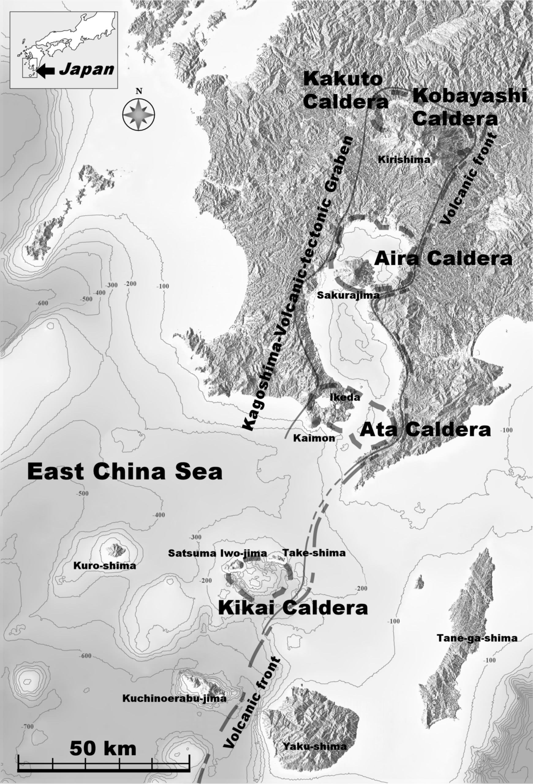 |
Figure 1. Geomorphological map of Southern Kyushu, and location of Kikai caldera, southern part of Kagoshima Volcanic tectonic graben.
 |
Figure 2. Geomorphological map of Kikai caldera. Inside the caldera, post-caldera volcanoes, Iwo-dake, Inamura-dake, and Showa Iwo-jima volcanoes grow up.
2. Eruptive history before the 7.3 ka eruption
Volcanic activities in the Kikai caldera began about 700 ka (Ono et al., 1982). In earlier period than the caldera-forming stage, the activities are characterized by a bimodal volcanism with which the products are divided into two groups; a mafic group (Yahazu-yama volcano in Satsuma Iwo-jima, Magome-yama volcano, and Takahira-yama volcano in Take-shima) and a felsic group (Sannoe-hana-lava, Akasaki-lava) (Table 1). In later period, multiple caldera-forming eruptions have occurred within the latest a few hundreds of thousand years (Ono et al., 1982). Deposits from these eruptions are distributed on some islands in and around the Kikai caldera.
Outside the caldera wall of two islands of Kikai caldera, there are three sheets of ignimbrite at least (Fig. 3). The oldest ignimbrite is that of Koabi ignimbrite (K-ab; Ono et al., 1982), which is distributed on the eastern base of Take-shima and the northern base of Satsuma Iwo-jima. The age is about 140 ka (Machida et al., 2001). Next, the Nagase ignimbrite (K-Ns; Ono et al., 1982), which erupted at about 95 ka, is only distributed on Take-shima. The latest ignimbrite is derived from the Koya (Take-shima) pyroclastic flow (K-Ky; Ui, 1973; Ono et al., 1982). The age of the ignimbrite is 6.5 ka (Kitagawa et al., 1995) and calibulated to 7.3 ka in later. Another Koseda ignimbrite is the oldest one erupted from the Kikai caldera, which is only distributed on Tane-ga-shima and Yaku-shima, and not on two islands of the Kikai caldera and which has an age of about 580 ka (Moriwaki et al., 2000). On both of Satsuma Iwo-jima and Take-shima, the Komoriko tephra group (K-Km) was deposited more than 10 m thick, and the 14C age indicates that this activity occurred from 13 to 8 ka (Okuno et al., 2000). Nagahama lava, whish is composed of the western side of Satsuma Iwo-jima, is also immediately before the 7.3 ka eruption (Kobayashi and Hayakawa, 1984), but the precise age is unknown. Inside the caldera wall on the Satsuma Iwo-jima, there are rhyolitic and basaltic lavas and tephras, which erupted from the Iwo-dake and Inamura-dake volcanoes after the latest caldera-forming eruption (Ono et al., 1982; Kawanabe and Saito, 2002; Maeno and Taniguchi, 2005).
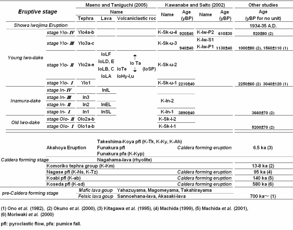 |
Table 1. Geological units of Kikai caldera
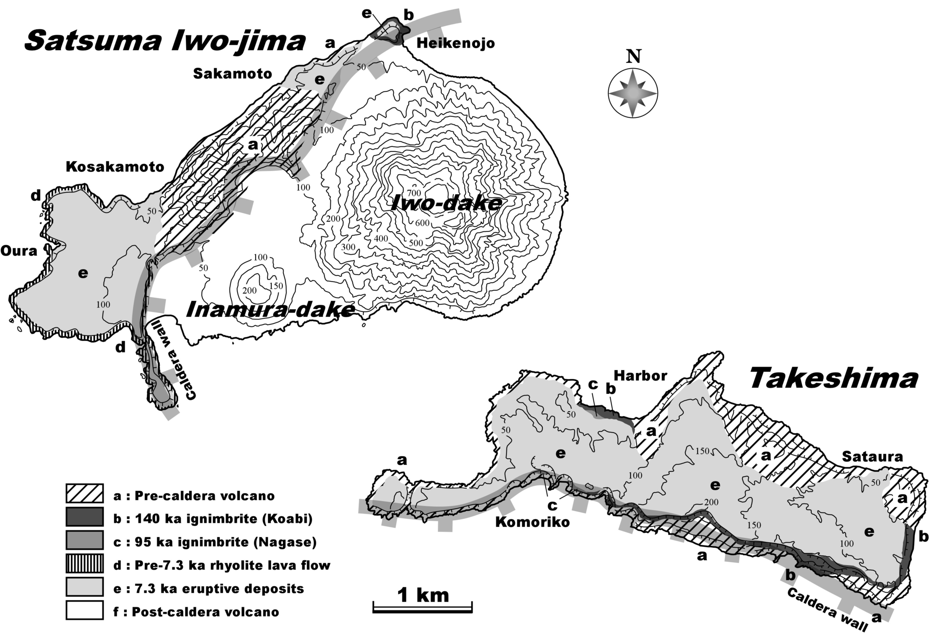 |
Figure 3. Geological map of Satsuma Iwo-jima and Take-shima. Outside the caldera wall of two islands, there are three major sheets of ignimbrite at least (modified from Ono et al. 1982).
3. 7.3 ka marine caldera-forming eruption
The 7.3 ka eruption of the Kikai volcano, southern Kyushu, occurred in a shallow sea, and dispersed extensive co-ignimbrite ash-fall in and around the Sea of Japan (Machida and Arai, 1978; 1983; 1992). This eruption (Volcano Explosive Index, VEI, is 7) was larger in scale than the Santorini and Krakatau eruptions (VEI 6), and was the largest in the past ten thousand of years in Japan. Previous researchers (Ui, 1973; Ono et al., 1982; Walker et al., 1984) characterized a major sequence of the deposits in the 7.3 ka Kikai eruption. Maeno and Taniguchi (2007) reconstructed this eruption based on analyses of the stratigraphy, textural, and lithofacies characteristics, and components of the pyroclastic deposits especially in proximal islands.
4. Eruptive history of Satsuma Iwo-jima Island after the 7.3 ka eruption
The volcanic activity in Satsuma Iwo-jima island after the 7.3 ka eruption is divided into three main stages and ten sub-stages based on volcanic edifice development and tephra deposits (Fig. 4); the old Iwo-dake stage (stage OIo-I-II), the Inamura-dake stage (stage In-I-IV), and the young Iwo-dake stage (stage YIo-I-IV) (Maeno and Taniguchi, 2005). The old Iwo-dake stage was initiated by phreatomagmatic eruptions and pumice fallout (stage OIo-I), followed by the effusion of rhyolitic lava with continuous ejection of ash and lithic fragments, resulting in building up an old volcanic edifice (stage OIo-II). In the stage OIo-II, intermittent explosive eruptions also occurred. The Inamura-dake stage is characterized by the effusion of basaltic lava flows and scoria-cone building (stage In-I-II). After that, at the western foot of the cone, phreatomagmatic explosions occurred (stage In-III) and andesitic lava flow effused (stage In-IV). In the young Iwo-dake stage, the explosive eruption occurred at the beginning (stage YIo-I), followed by the effusion of multiple rhyolitic lava flows from the summit crater and the formation of hyaloclastite in shallow sea that made up the marine terrace (stage YIo-II). During the past 1000 years, the volcanic activity changed to intermittent ones with pumice and bomb fallout (stage YIo-III-IV). Total phenocryst contents of the Iwo-dake lavas increased up to 8 vol. % through the young stages (Fig. 5). The magma of the young Iwo-dake stage is different from that of the 7.3 ka eruption and the old Iwo-dake stage, bordered by the Inamura-dake stage.
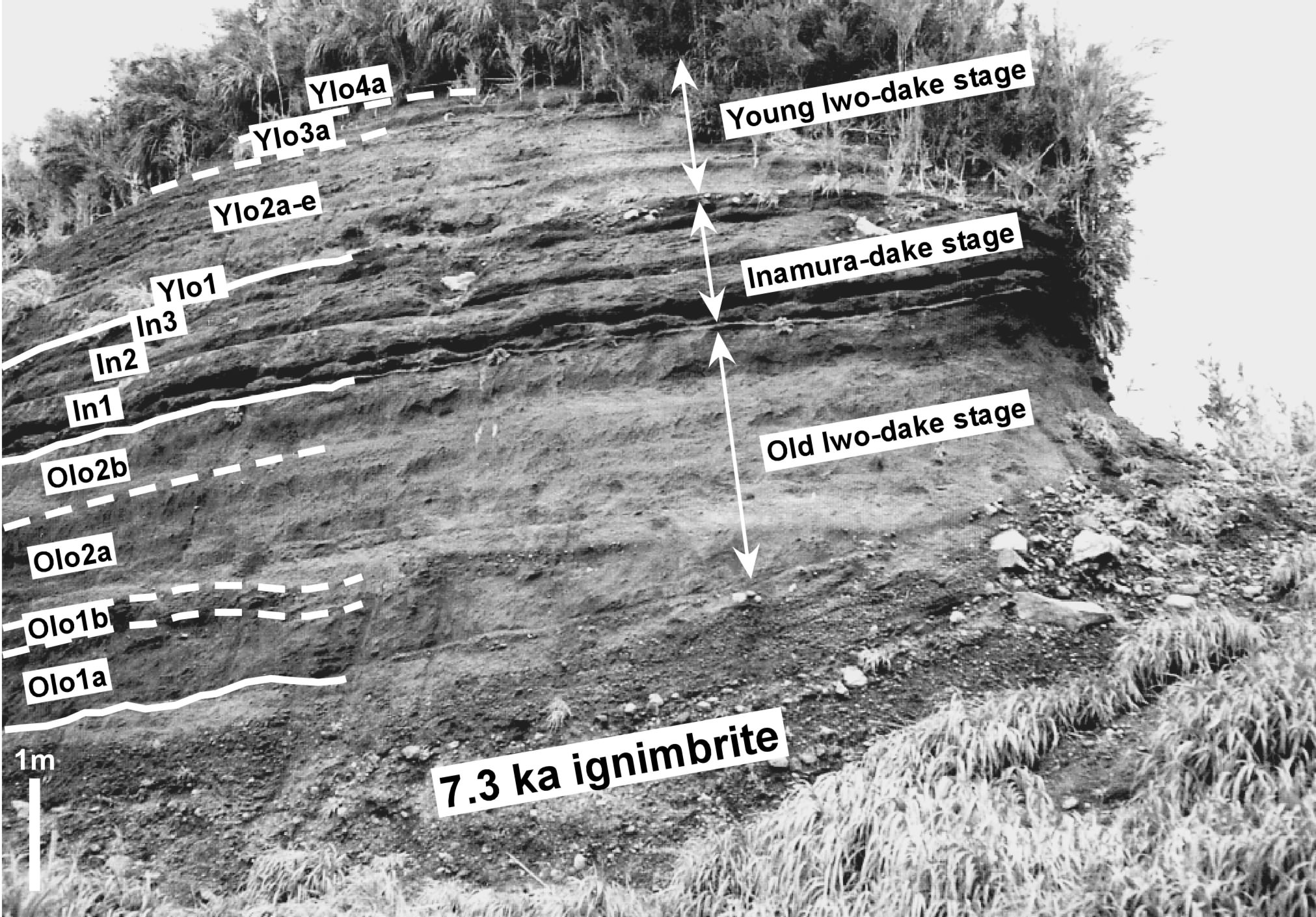 |
Figure 4. Photograph of the outcrop at Sakamoto, Satsuma Iwo-jima. OIo1aÅ`2b, In1Å`3, and YIo1Å`4a are derived from the Old Iwo-dake volcano, the Inamura-dake volcano, and the Young Iwo-dake volcano, respectively.
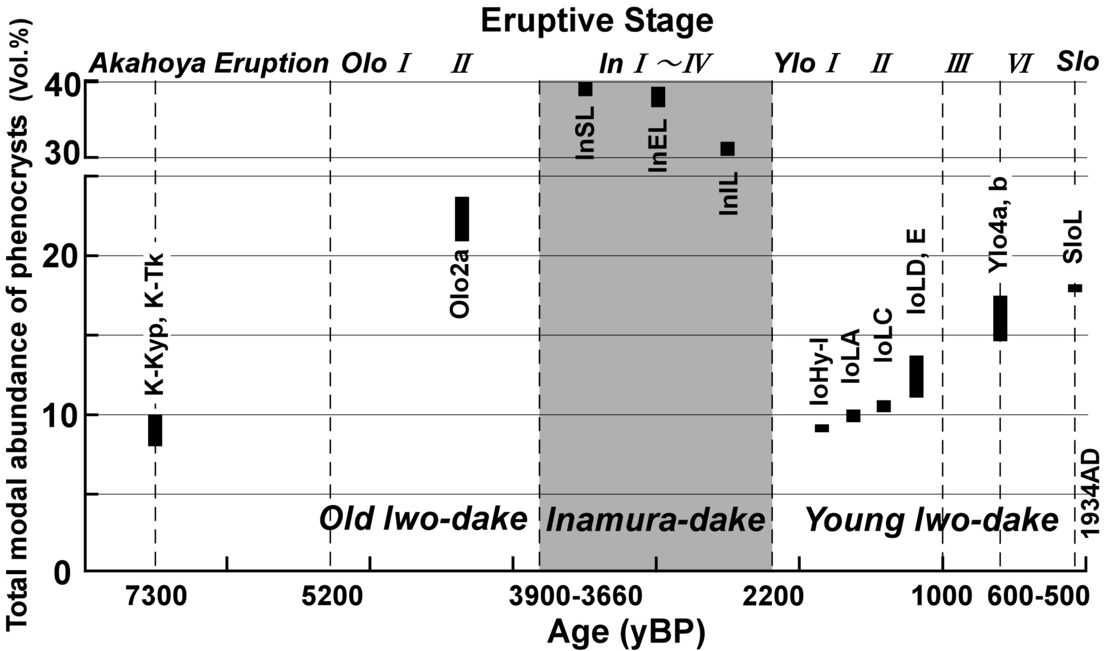 |
Figure 5. Variations of modal abundance of phenocryst in volcanic rocks for the past 7300 years. The rock of the stage OIo-áUis more crystal-rich (> 20 vol.%) than that of other stages (< 20 vol.%). In the Young Iwo-dake stage, the modal abundance increased gradually with decreasing age.
5. Latest marine eruption: Showa Iwo-jima eruption in 1934-1935
In 1934-1935, a new silicic lava dome, Showa Iwo-jima Island, was produced from a submarine eruption, which is the latest magmatic eruption in the Kikai caldera (Tanakadate, 1935a, 1935b; Matumoto, 1936; Maeno and Taniguchi, 2006). The eruption started with a silicic lava extrusion onto the floor of the submarine Kikai caldera and ceased with the emergence of a lava dome.
5-1. Sequence of the eruption
The Showa Iwo-jima eruption in 1934-1935 is divided into the following four stages (Maeno and Taniguchi, in press). The first stage was characterized by submarine activity. Floating pumices (Kano, 2003) were first noticed in September 1934 and were accompanied by earthquakes (Fig. 6a, b). The second stage started around December 8 when a pyroclastic cone first became visible above sea level and emitted Åewhite smokeÅf from its crater. During this stage, there were numerous explosive eruptions repeated at intervals of 1-2 minutes. Each eruption ejected enormous cauliflower-shaped Åedark smokeÅf through the middle of the Åewhite smokeÅf. The pyroclastic cone was destroyed by a strong explosion on December 30. The third stage was characterized by lava effusion, accompanied by some phreatomagmatic eruptions which generated cockÅfs tail jets repeated at intervals of less than a few minutes. In early January 1935, new lava emerged on the western side of the islet. On January 8, a new pyroclastic cone was visible on the lava (Fig. 6c). On January 21, the height of the new cone exceeded 12 m above high tide level. The volcanic islet had a maximum length of 300 m in the NE direction and was about 150 m across (Fig. 6d). In the fourth stage from late January to March, new silicic lava effused and a dome grew. On February 10, a new small islet, composed of lava, appeared 50 m northwest from the main islet. In early March, small explosions were sometimes observed. The central crater of the main islet widened and the crater rim collapsed. Later, effusion of a large amount of lava buried the entire crater. The former pyroclastic cone was covered by the lava. On March 26, a new main islet, the present Showa Iwo-jima lava dome, was observed with little ÅesmokeÅf. All activity seemed to decline at this time. The dome was about 300 m in length in the NS direction and 530 m across, and its height was 55 m above sea level (Fig. 6d, e). Part of the other new islet near the main dome disappeared in 1936 as a result of erosion by wave action.
 |
Figure 6. (a) Submarine eruption of Showa Iwo-jima with a plume of steam, viewed from the summit crater of Iwo-dake volcano (September 1935). The diameter of the plume was not described, but was probably less than 1 km. (b) The blocks of pumice (arrows) floating on the sea (September 1935). The size of the largest block reached about 10 m in length. (c) New lava islet, viewed from the top of Iwo-dake volcano (January 1935). (d) Sketches of the Showa Iwo-jima dome (January 21 and March 31, 1935) based on direct observation by Tanakadate and modified from Tanakadate (1935a, b). The cone was made of pyroclastic deposits. (e) Map of the Showa Iwo-jima dome before erosion by wave action (July 1935; Matumoto, 1936) and at present. Photos by Tanakadate in Matumoto (1943).
5-2. Growth of a marine silicic lava dome
Surface and internal structure of the Showa Iwo-jima lava dome are well exposed and preserved, providing a good opportunity for examining marine lava dome growth (Fig. 7). Maeno and Taniguchi (2006) described the partly emergent Showa Iwo-jima lava dome in detail, and discuss the formation process of the dome and condition of erupted magma, reflecting the combination of submarine and subaerial settings.
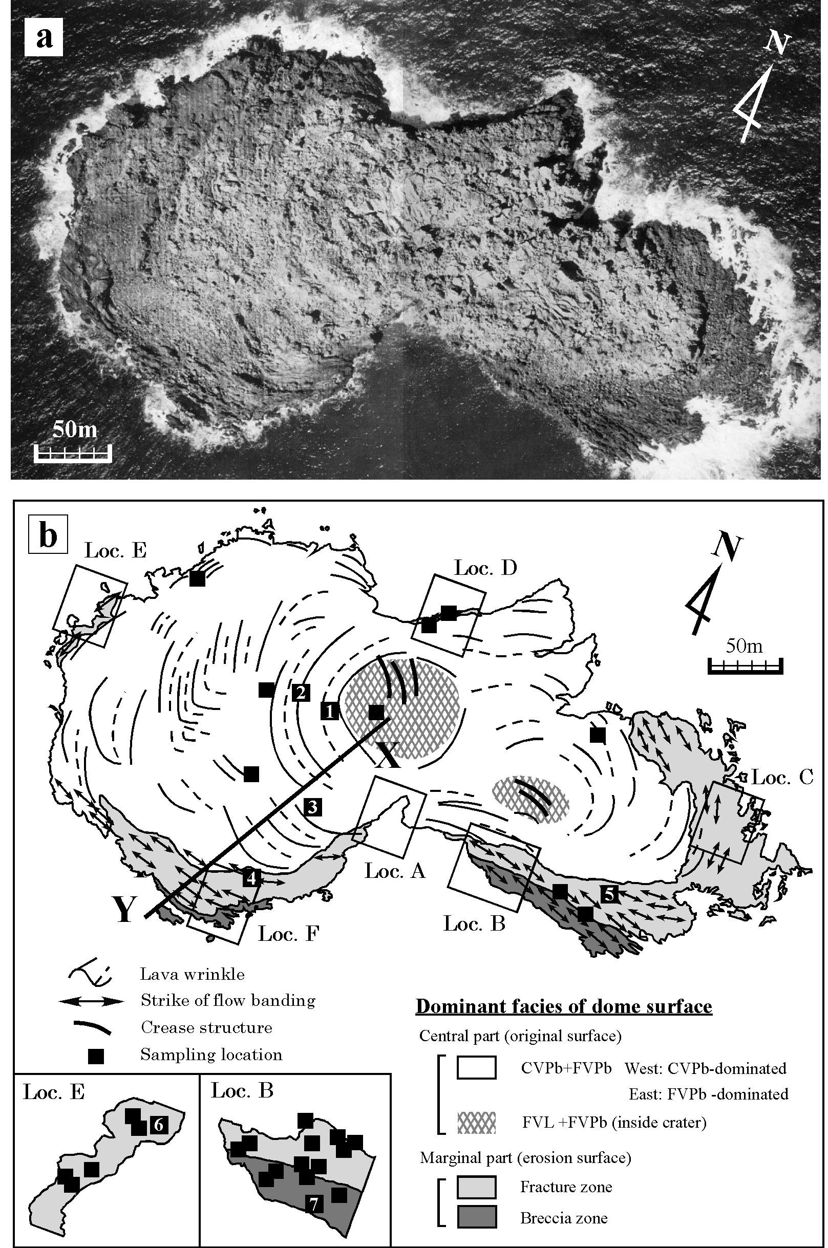 |
Figure 7. (a) Aerial photograph of Showa Iwo-jima dome taken by the Geographical Survey Institute of Japan in 1977. (b) Geological map of Showa Iwo-jima dome. The outer margin is well-exposed due to erosion of wave action. Locations A-H are representative outcrops investigated. Solid and dashed lines show crests and troughs of wrinkles, and thick solid lines show the axes of crease structures. Arrows show the strike of subvertical flow-banding. Closed squares are sampling localities. FVL, finely vesicular lava; FVPb, finely vesicular pumice breccia; CVPb, coarsely vesicular pumice breccia.