| Point-No. |
Longitude |
Latitude |
Ground elevation[m] |
Standard plane to measure the ground elevation |
Inundation height[m] |
Inundation depth[m] |
Distance from shore line[m] |
Inundation or Runup |
Measured time |
Tsunami arrival time |
Tide level at the event from Lowest Low Level[m] |
Tide level at the measured time from Lowest Low Level[m] |
Reliability |
Time difference |
Note |
Tsunami height[m] |
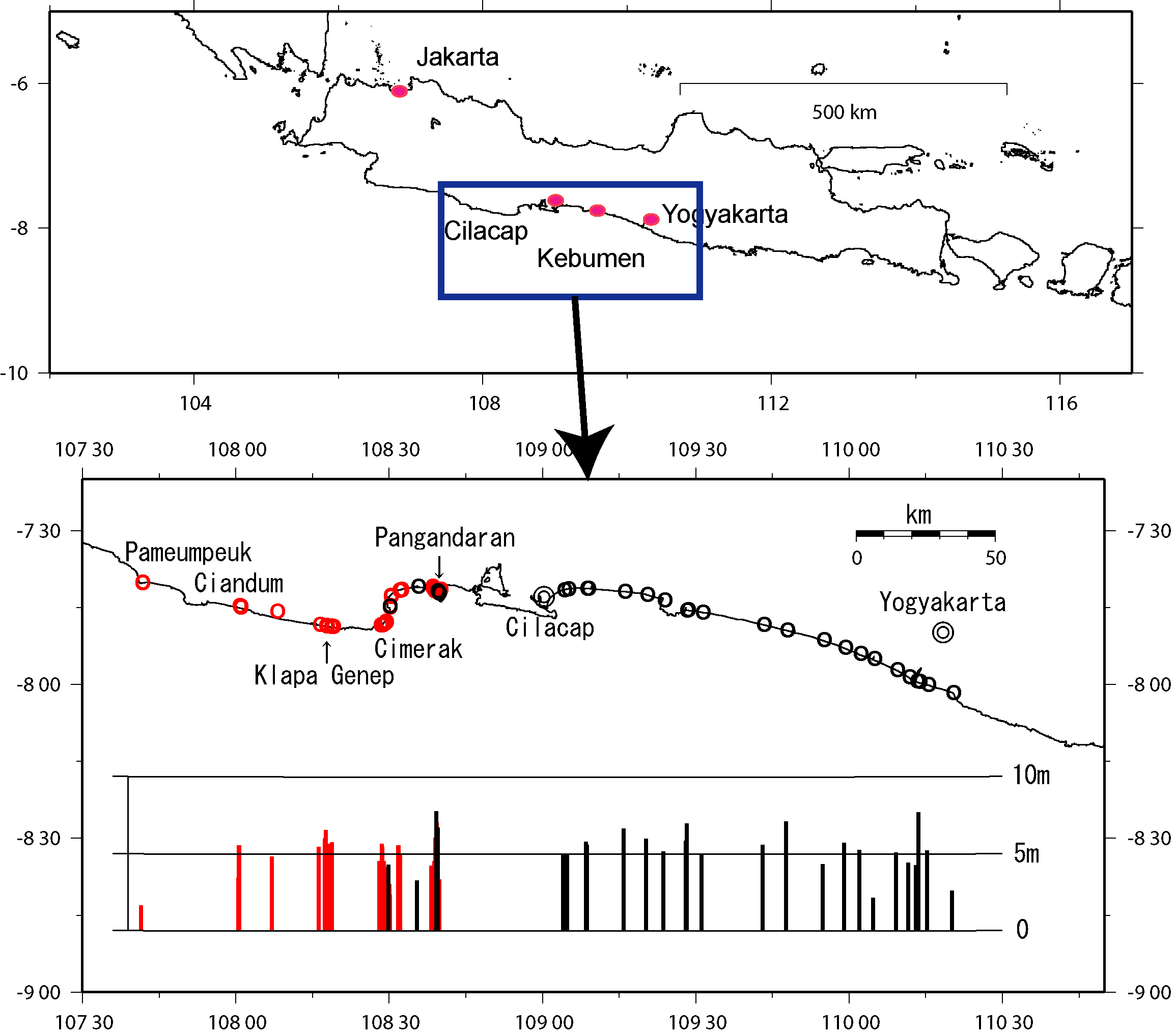
| Pangandaran west coast |
E108°38.81′ |
S7°41.405′ |
- |
- |
- |
- |
- |
- |
- |
- |
- |
- |
- |
- |
According to the witness accounts, the sea level went down at first due to the tsunami wave. The wave came twice. The first wave was 3m and the second was 5m. |
- |
| the whole Pangandaran |
- |
- |
- |
- |
- |
- |
- |
- |
- |
- |
- |
- |
- |
- |
According to the witness accounts, in the whole Pangandran, the tsunami wave came into 500m inland from the shore line. The earthquake continued for 3 minutes. |
- |
| Pangandaran East coast |
E108°39.498′ |
S7°42.115′ |
3.26 |
Sea level |
6.76 |
3.50 |
about 30m |
Inundation |
11:35
5.Aug.2006 |
15:40,
17.Jul.2006 |
0.98 |
0.82 |
B |
UTC+7h |
Tiles slipped off a roof. According to witness accounts, the tsunami wave came three times and the second wave was the largest. The earthquake were not so strong that almost all the people did not feel it. |
6.60 |
| Pangandaran West, Bima Nusantra Hotel |
E108°39.363′ |
S7°41.965′ |
2.80 |
Sea level |
5.83 |
3.03 |
about 100m |
Inundation |
11:55
5.Aug.2006 |
15:40,
17.Jul.2006 |
0.98 |
0.82 |
A |
UTC+7h |
An inundation line on a roof. |
5.67 |
| Pangandaran West |
E108°39.25′ |
S7°41.78′ |
3.08 |
Sea level |
7.72 |
4.64 |
about 100m |
Inundation |
12:10
5.Aug.2006 |
15:40,
17.Jul.2006 |
0.98 |
0.83 |
C |
UTC+7h |
An inundation line on a wall of a shower room. Graves for victims due to the tsunami were made in the north part of this place. |
7.57 |
| Batukaras |
E108°29.89′ |
S7°44.905′ |
2.55 |
Sea level |
4.27 |
1.72 |
about 50m |
Inundation |
16:07
5.Aug.2006 |
15:40,
17.Jul.2006 |
0.98 |
0.94 |
B |
UTC+7h |
An electric lamp on a gatepost in a Hotel was destroyed due to the tsunami. |
4.23 |
| Karantirta |
E108°35.428′ |
S7°40.808′ |
0.34 |
Sea level |
3.24 |
2.90 |
about 1km |
Inundation |
17:00
5.Aug.2006 |
15:40,
17.Jul.2006 |
0.98 |
0.93 |
A |
UTC+7h |
An inundation line on a wall. This place is 1km from the open sea but 30m from a lagoon. This height is from the water level of the lagoon. The water level of the lagoon may be 50cm-1m above that of the open sea. |
3.19 |
| Cilacap port |
E109°.067′ |
S7°44.283′ |
- |
Sea level |
2.00 |
- |
0 |
Inundation |
|
15:40,
17.Jul.2006 |
0.98 |
|
B |
UTC+7h |
This tsunami height was measured by the witness account of the BMG officer. |
- |
| Mangati (Cilacap city) |
E109°4.778′ |
S7°41.367′ |
2.12 |
Sea level |
4.92 |
2.80 |
about 300m |
Inundation |
08:50
6.Aug.2006 |
15:40,
17.Jul.2006 |
0.98 |
1.14 |
A |
UTC+7h |
An inundation line suggested by Mr. Feria Sukardi. In this place, nobody felt the earthquake. The tsunami wave came three times and the second wave was the largest. |
5.08 |
| Lengkong (Cilacap City) |
E109°4.045′ |
S7°41.578′ |
1.90 |
Sea level |
over 4.9 |
over 3.0 |
about 300m |
Inundation |
09:12
6.Aug.2006 |
15:40,
17.Jul.2006 |
0.98 |
1.08 |
C |
UTC+7h |
According to the witness accounts, the building whose height was 3m was completely covered with the tsunami wave. Nobody felt the earthquake. At first, the sea water went down about 50m in the horizontal direction before the tsunami wave attacking. |
over 5.0 |
| Bunton |
E109°8.69′ |
S7°41.223′ |
5.74 |
Sea level |
5.74 |
nearly 0 |
about 150m |
Inundation |
10:18
6.Aug.2006 |
15:40,
17.Jul.2006 |
0.98 |
0.90 |
A |
UTC+7h |
A trace of the tsunami waves existed in grasses on the top of a dune. The tsunami height was regarded as the height of the top of the dune. |
5.66 |
| Bunton |
E109°8.483′ |
S7°41.262′ |
3.56 |
Sea level |
5.76 |
2.20 |
about 700 |
Inundation |
10:18
6.Aug.2006 |
15:40,
17.Jul.2006 |
0.98 |
0.90 |
A |
UTC+7h |
An inundation line of eaves of a hut. |
5.68 |
| Binagun |
E109°15.865′ |
S7°41.865′ |
3.50 |
Sea level |
6.60 |
3.10 |
about 200m |
Inundation |
11:32
6.Aug.2006 |
15:40,
17.Jul.2006 |
0.98 |
0.77 |
B |
UTC+7h |
Seaweeds on a tree. In this place, the 49 people were killed due to the tsunami wave. |
6.39 |
| Karang Pakis (Nusa Wung) |
E109°20.192′ |
S7°42.453′ |
5.94 |
Sea level |
5.94 |
0.00 |
about 300m |
Runup |
13:20
6.Aug.2006 |
15:40,
17.Jul.2006 |
0.98 |
0.71 |
B |
UTC+7h |
Trashes were laid as a line. |
5.67 |
| Ayah |
E109°23.637′ |
S7°43.475′ |
2.72 |
Sea level |
5.12 |
2.40 |
about 50m |
Inundation |
14:07
6.Aug.2006 |
15:40,
17.Jul.2006 |
0.98 |
0.74 |
A |
UTC+7h |
According to the witness accounts, the tsunami wave went up to a roof of a hut in a park. Nobody felt the earthquake. The tsunami wave came three times and the second was the largest. |
4.88 |
| Parang Tritis (south of Yogyakarta) |
E110°20.008′ |
S8°1.558′ |
2.00 |
Sea level |
2.57 |
0.57 |
about 200m |
Inundation |
09:25
7.Aug.2006 |
15:40,
17.Jul.2006 |
0.98 |
1.25 |
A |
UTC+7h |
An inundation line on an inside wall of a shower room at a beach for swimming. |
2.84 |
| Pantai Pandansari (Sandakan) |
E110°15.2′ |
S8°.035′ |
5.18 |
Sea level |
5.18 |
0.00 |
about 150m |
Runup |
10:20
7.Aug.2006 |
15:40,
17.Jul.2006 |
0.98 |
1.04 |
A |
UTC+7h |
According to the witness accounts, the tsunami wave came to a tip of a pavement road which connected to the sea. The tsunami wave came three times and the second was the largest. Nobody felt earthquake. No injury occurred due to the earthquake and tsunami in this place. |
5.24 |
| Pantai Kuwaru |
E110°13.575′ |
S7°59.457′ |
7.66 |
Sea level |
7.66 |
nearly 0 |
about 150m |
Inundation |
10:54
7.Aug.2006 |
15:40,
17.Jul.2006 |
0.98 |
0.91 |
B |
UTC+7h |
Grasses on a top of a dune were laid due to the tsunami. |
7.59 |
| Pantai Kuwaru |
E110°13.575′ |
S7°59.457′ |
5.77 |
Sea level |
6.04 |
0.27 |
about 150m |
Inundation |
10:54
7.Aug.2006 |
15:40,
17.Jul.2006 |
0.98 |
0.91 |
A |
UTC+7h |
An Inundation line on an inside concrete wall around a light house. This wall formed as a bathtub and enclosed the light house. This light house stood off about 20m behind from the above dune. |
5.97 |
| Pandang Simo |
E110°13.04′ |
S7°59.277′ |
4.22 |
Sea level |
4.24 |
0.02-0.03m |
about 150m |
Inundation |
11:03
7.Aug.2006 |
15:40,
17.Jul.2006 |
0.98 |
0.88 |
B |
UTC+7h |
Sea sand were piled up on a concrete floor. The tsunami height was regarded as the height of the floor. |
4.14 |
| Galur Pantai Trisik |
E110°11.612′ |
S7°58.45′ |
4.40 |
Sea level |
4.40 |
0.00 |
about 100m |
Runup |
15:07
7.Aug.2006 |
15:40,
17.Jul.2006 |
0.98 |
0.65 |
B |
UTC+7h |
According to the witness accounts, the tsunami wave came up to an edge of a road. The tsunami height was regarded as the height of the edge. |
4.07 |
| Pantai Bugel Peni |
E110°9.175′ |
S7°57.1′ |
5.05 |
Sea level |
5.05 |
0.00 |
about 100m |
Runup |
15:54
7.Aug.2006 |
15:40,
17.Jul.2006 |
0.98 |
0.75 |
B |
UTC+7h |
Trashes were laid as a line. |
4.82 |
| Glagah (Temon City) |
E110°4.682′ |
S7°54.923′ |
2.10 |
Sea level |
2.10 |
0.00 |
about 300m |
Runup |
16:36
7.Aug.2006 |
15:40,
17.Jul.2006 |
0.98 |
0.85 |
B |
UTC+7h |
According to the witness accounts, trashes had been laid as a line. This place was 300m from the open sea but 20m from a lagoon. The tsunami wave may once come to the lagoon and came to this point from the lagoon. The tsunami wave came twice. |
1.97 |
| Pantai Congot(Temon City) |
E110°2.038′ |
S7°53.992′ |
4.40 |
Sea level |
5.20 |
0.80 |
about 200m |
Inundation |
08:36
8.Aug.2006 |
15:40,
17.Jul.2006 |
0.98 |
1.66 |
A |
UTC+7h |
An Inundation line on a wall by the witness account. Nobody felt the earthquake. The inhabitants saw a cloud like a mushroom cloud. The tsunami wave went up to about 150m inland from the sea. |
5.88 |
| Jatimalang (Pantai Prejo) |
E109°58.998′ |
S7°52.745′ |
5.09 |
Sea level |
5.69 |
0.60 |
about 200m |
Inundation |
09:21
8.Aug.2006 |
15:40,
17.Jul.2006 |
0.98 |
1.51 |
B |
UTC+7h |
According to the witness accounts, the tsunami wave went up to a knee on a concrete floor. The tsunami wave came twice and the first was the largest. Before tsunami coming, the inhabitants saw clouds like a pencil on a horizon and then they saw clouds like a mushroom cloud. They felt lights like thunder and the three sounds like guns. |
6.22 |
| Pantai Keburuhan |
E109°54.787′ |
S7°51.25′ |
3.58 |
Sea level |
over 4.48 |
over 0.90 |
about 100m |
Inundation |
10:15
8.Aug.2006 |
15:40,
17.Jul.2006 |
0.98 |
1.29 |
C |
UTC+7h |
A reinforced concrete column was destroyed due to the tsunami and the tsunami height was regarded as the top of the column. So the actual tsunami height may be larger than this height. The inhabitants saw a vertical cloud like a column far out at sea before the tsunami attacking. They felt sounds like a blast. Nobody felt the earthquake. |
over 4.79 |
| Pantai Keburuhan |
E109°54.787′ |
S7°51.25′ |
3.03 |
Sea level |
3.48 |
0.45 |
about 100m |
Inundation |
10:15
8.Aug.2006 |
15:40,
17.Jul.2006 |
0.98 |
1.29 |
A |
UTC+7h |
According to the witness accounts, the tsunami wave went up to 45cm above a concrete floor. This floor was off 20m from the above reinforced concrete column. |
3.79 |
| Rowo |
E109°47.705′ |
S7°49.393′ |
6.47 |
Sea level |
7.07 |
0.60 |
about 100m |
Inundation |
12:01
8.Aug.2006 |
15:40,
17.Jul.2006 |
0.98 |
0.78 |
B |
UTC+7h |
The tsunami wave went up to the forth block of a hut. |
6.87 |
| Rowo |
E109°47.705′ |
S7°49.393′ |
5.94 |
Sea level |
over 5.94 |
nearly 0 |
about 100m |
Inundation |
12:01
8.Aug.2006 |
15:40,
17.Jul.2006 |
0.98 |
0.78 |
B |
UTC+7h |
A trace of the tsunami waves existed in grasses on a top of a dune. The tsunami height was regarded as the height of the dune. This place was 50m inland from the above hut. |
over 5.74 |
| Ambal |
E109°43.088′ |
S7°48.287′ |
5.54 |
Sea level |
5.54 |
0.00 |
about 100m |
Runup |
14:50
8.Aug.2006 |
15:40,
17.Jul.2006 |
0.98 |
0.47 |
B |
UTC+7h |
Trashes were laid as a line. Before tsunami attacking, the inhabitants felt sounds like a blast. |
5.03 |
| Puring |
E109°31.108′ |
S7°45.88′ |
4.87 |
Sea level |
4.87 |
0.00 |
about 100m |
Runup |
16:07
8.Aug.2006 |
15:40,
17.Jul.2006 |
0.98 |
0.62 |
B |
UTC+7h |
Trashes were laid as a line. |
4.51 |
| Puring |
E109°31.108′ |
S7°45.88′ |
4.54 |
Sea level |
4.54 |
0.00 |
about 100m |
Runup |
16:07
8.Aug.2006 |
15:40,
17.Jul.2006 |
0.98 |
0.62 |
B |
UTC+7h |
Trashes were laid as a line. These trashes were off 50m from the above trashes. |
4.18 |
| Pantai Suwuk |
E109°28.217′ |
S7°45.44′ |
4.19 |
Sea level |
6.94 |
2.75 |
about 250m |
Inundation |
17:00
8.Aug.2006 |
15:40,
17.Jul.2006 |
0.98 |
0.81 |
A |
UTC+7h |
According to the witness accounts, the tsunami wave went up to 5cm above a roof of a factory. When the tsunami came, the roof of the factory was pushed by the air due to the tsunami wave attacking, and the roof was partially destroyed. The destroyed hole was about 3m^2 by the brief observation. In this place, the 9 people were killed due to the tsunami. Nobody felt the earthquake. Before tsunami attacking, the sea water went down about 50m horizontally. |
6.77 |
| Kapang Bolong |
E109°28.015′ |
S7°45.475′ |
5.80 |
Sea level |
5.80 |
0.00 |
about 80m |
Runup |
17:45
8.Aug.2006 |
15:40,
17.Jul.2006 |
0.98 |
0.98 |
B |
UTC+7h |
Trashes were piled up behind a house. The tsunami wave came three times. The first was about 3m and the second was the largest. In this place the 2 people were killed due to the tsunami. The inhabitants felt sounds like a blast at 16:00. The first tsunami wave came at 16:15. |
5.80 |