8-6. Earthquake Observation Center
The Earthquake Observation Center was established by integrating the
observation divisions, the earthquake prediction observation
center and the observatories when the Earthquake Research Institute
was reorganized in 1994. At present, the center is composed of
the four observational research groups for earthquakes, crustal movements,
and strong motions. The center has ten observatories and
the large-scale regional observation networks covering the districts
of Kanto-koshin'etsu, Kii Peninsula, Shikoku, and the western
Seto inland sea regions. The center, in order to approach earthquake
prediction and disaster mitigation, has been actively conducting
observational researches to clarify the mechanisms and the processes
of earthquake generation, and has been developing observational
techniques and instruments. The Earthquake Observation Center has been
also conducting the collaborative observational researches
with universities and other related institutions to promote earthquake-prediction
program.
Earthquake Research Group
Seismic activities, rupture processes of earthquakes and heterogeneous
crustal structures have been investigated using the
high-sensitivity seismic networks of more than one hundred stations
covering the areas of Kanto-koshin'etsu, Kii Peninsula, and
western Seto inland. A data telemeter system utilizing a satellite
has been developed and has been in operation since 1996, which has
ensured to establish a real-time transfer of a huge amount of earthquake
waveform data. The data telemeter system has been also
effectively utilized in mobile seismic observations. The Earthquake
Observation Center is responsible for the cooperative researches
using the satellite-telemeter system.
Earthquake swarms, having repeatedly occurred off the East coast of
the Izu Peninsula, have been intensively studied to clarify the
mechanisms using the dense network of land stations and the optic-cable
linked ocean-bottom seismometer network system that was
deployed in 1994.
The Earthquake Observation Center has been the responsible organization
since 1999 for the extensive researches composed of the
well-organized seismic refraction/reflection profiling and the seismic
studies with an off-line dense array in Hokkaido area.
Marine Earthquake Research Group
Seismic activities and tsunami off Sanriku, Tohoku district, where tsunami
earthquakes have historically and repetitively occurred,
have been studied using the optic-cable linked ocean-bottom seismic
stations and tsunami stations and pop-up ocean-bottom
seismometers. Moreover, seismic activities and geodynamics at the plate
boundaries around Japan have been studied with using a
pop-up ocean-bottom seismometer array.
For the long-term seismic observations, the high-quality pop-up ocean-bottom
seismometers with the life of >1-year continuous
recording have been developed. For the marine quasi-real-time observations,
the telemeter buoy system utilizing the satellite- and
acoustic-communication links has been developed, which were temporarily
deployed off Kozu-shima, Izu-islands, Tokyo in 2000 for
observing the earthquake swarms associated with the magma activities
of the Miyake-jima eruptions.
The ocean-bottom instruments measuring crustal movements such as strain
and tilts have been developed and installed in the
Nokogiriyama examination wells for marine crustal movements observation
tools.
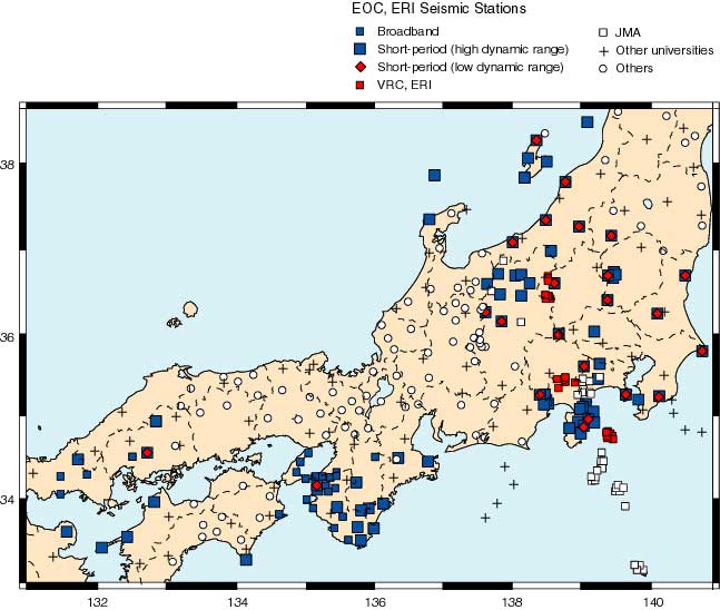
Fig.1. Map of the seismic stations of the Earthquake Observation
Center.

Fig.2. System diagram of the seismic observation network in the Kanto-koshin'etsu
area.
Crustal Movements Research Group
Crustal dynamics and relationship between crustal movements and earthquake
occurrence have been investigated by using data
obtained from observation stations monitoring continuous crustal movements,
and EDM and GPS array stations, together with
groundwater measurements. Multi-component borehole observation instruments
have been developed and enabled us to record six
components of strain, two components of tilt, temperature, and three
components of seismic waves. They are equipped with a newly
developed gyro for positioning the instruments when installed in deep
boreholes. They have been deployed at areas where earthquake
swarms occur and next destructive earthquakes may occur in the future
as Kanto-Tokai and Nankai areas, being installed in deep
boreholes at depths from 150 m to 800 m.
Strong Motion Research Group
Major objectives are: (1) to understand the generation and the propagation
of strong ground motions from large earthquakes through
strong motion observations at rock sites surrounding Suruga Bay where
a large earthquake of M8 is anticipated and Izu Peninsula
regions, and (2) to evaluate the effects of surface geology on strong
motions using the array observation data at Ashigara valley. A
quasi real-time information system for strong ground motions is under
development. This system will focus on dispatching additional
data that will allow a local government or other organization to respond
quickly. The group collaborates with the Division of Disaster
Mitigation Science.

Fig.3. Strong motion observation network of the Earthquake Observation
Center in the Kanto-Tokai area plotted
on the geological map by the Geological Survey of Japan.
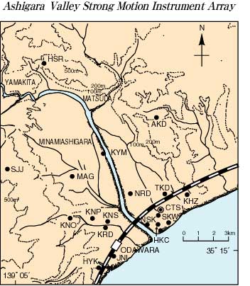
Fig.4. Array strong motion observation in Ashigara valley.
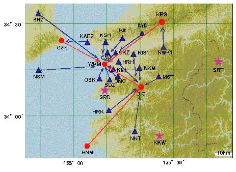
Fig.5. Local seismic observation network in the Kii peninsula operated
by the Wakayama Seismological Observatory.
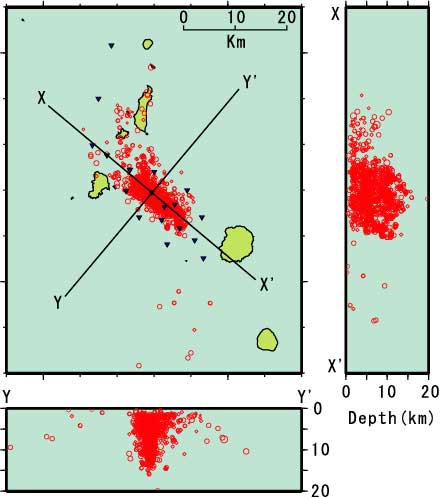
Fig.6. Hypocentral distributions between the Miyake-jima Island and
the Kozu-shima Island.
The hypocenters are the relocated
ones using the station corrections determined by the ocean bottom
seismometer observations. The deeper distributions
(>7 km) of the hypocenters look like almost-vertically
standing thin-plates of the width of about 2 km.

Fig.7. Nokogiriyama Geophysical Observatory: Watertube tiltmeter
and extensometer (center), the inside view of
the observation vault (right lower), and the entrance of the observation
vault (left upper).
Top Next