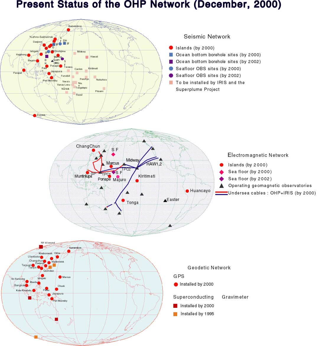
Fig.1 (Top) Ocean hemisphere seismic observation network. (Middle) Ocean hemisphere geomagnetic and geoelectric observation network. (Bottom) Ocean hemisphere geodetic observation network.
In the recent years, the dynamic nature of the Earth's interior has been recognized as a result of various interactions. It is necessary to have an observation network of a global scale in order to fully understand physical phenomena on and within the Earth. From this viewpoint, ocean, which covers about 70% of the Earth's surface, can be regarded as a window to look into the Earth's interior without disturbance from complicated geological noises of the continental crust. At the same time, oceans, especially the Pacific, which is the largest on the globe, prevents us from building geophysical observation stations. In fact there have been few attempts to construct a geophysical network in the Pacific due to various difficulties. In the "Ocean Hemisphere Network", great efforts will be made to build a well-spread seismic, geomagnetic and geodetic networks in the Pacific to investigate the structure and the dynamics of the mantle and the core, and to reveal the physics of the Earth's activities.
Fig.1 (Top) Ocean hemisphere seismic observation network. (Middle) Ocean hemisphere geomagnetic and geoelectric observation network. (Bottom) Ocean hemisphere geodetic observation network.
There are four major activities of this center.
(1) Observation and maintenance of the seismic, geomagnetic and geodetic networks,
Because most long-term observation stations are built on islands in the Pacific, their maintenance require collaboration between institutions. A temporal array study, either on land or on the ocean bottom, will be done to support network observations.
(2) Development of new instruments and sensors.
It is obvious that stations on islands are not sufficient to build a network with the ideal configuration. Long-term sea floor stations for seismic and magnetic measurements are going to be developed to overcome this problem. A borehole seismic sensor will be developed to make a high-quality seismic observations on the sea floor.
(3) Data analysis and study on the structure and dynamics of the Earth's interior,
(4) Data distribution and exchange,
The data center is committed to distributing data to as many scientists
as possible, not only in Japan but also in other countries, to make a sufficient
contribution to the international scientific community.
Table 1 OHP Stations (March, 2000) |
|||||||
|
|
|
|
|
|
|
|
|
| Baguio | Philippines | BAG | 16.4 | 120.6 | VBB,24-bit | 1998/3- | |
| Inuyama | Japan | INU | 35.3 | 137.0 | VBB,24-bit | GEOSCOPE/OHP | 1998- |
| Ishigaki | Japan | ISG | 24.4 | 124.2 | VBB,24-bit | 1995/3- | |
| Jayapura | Indonesia | JAY | -2.5 | 140.7 | VBB,24-bit | 1997/12- | |
| Kamenskoe | Russia | KMS | 62.5 | 166.2 | VBB,24-bit | 1995/9-1996/2 | |
| Minamitorishima | Japan | MCSJ | 24.3 | 154.0 | BB,16-bit | JMA/OHP | 1996/12- |
| Chichijima | Japan | OGS | 27.1 | 142.2 | VBB,24-bit | 1992/7- | |
| Palau | Palau | PALU | 7.3 | 134.5 | VBB,24-bit | 1996/4-1997/5 | |
| Ponpei | Micronesia | PATS | 6.8 | 158.3 | VBB,24-bit | 1995/6- | |
| Pohan | Korea | PHN | 36.0 | 129.4 | VBB,22-bit | 1991/3-1996/8 | |
| Port Moresby | Papua New Guinea | PMG | -9.4 | 147.1 | VBB,24-bit | IRIS/OHP | 1993/9- |
| Parapat | Indonesia | PSI | 2.7 | 98.9 | VBB,24-bit | 1993/3- | |
| Syowa Station | Antarctica | SYO | -69.0 | 39.6 | VBB,24-bit | 1990/1- | |
| Tagaytai | Philippines | TGY | 14.1 | 120.9 | VBB,24-bit | 1992/2-1995/5 | |
| Taejon | Korea | TJN | 36.4 | 127.4 | VBB,22-bit | Event only | 1997/12- |
| Tsukuba | Japan | TSK | 36.2 | 140.1 | VBB,22-bit | 1989/10- | |
Table 2 GPS Stations |
||||
|
|
|
|
|
|
| Ishigaki | Japan | 24.4 | 124.2 | 1995/11- |
| Taejeon | Korea | 36.4 | 127.4 | 1995/4- |
| Marcus | Japan | 24.3 | 154.0 | 1995/7- |
| Manila | Philippines | 14.6 | 121.0 | 1995/8- |
| Chuuk | Micronesia | 7.4 | 151.9 | 1995/11- |
| Vladivostok | Russia | 43.2 | 131.9 | 1996/2- |
| Palau | Palau | 7.3 | 134.5 | 1996/5- |
| Okha | Russia | 53.6 | 142.1 | 1995/7- |
| Yuzhno-Sakhalinsk | Russia | 47.0 | 142.2 | 1995/7- |
| Port Moresby | Papua New Guinea | -9.4 | 147.2 | 1996/4- |
| Jayapura | Indonesia | -2.5 | 140.7 | 1997/3- |
| Khabarovsk | Russia | 48.5 | 135.1 | 1997/3- |
| Kota Kinabalu | Malaysia | 6.0 | 116.1 | 1997/11- |
| Uglegorsk | Russia | 49.1 | 142.0 | 1997/4- |
| Kamenskoe | Russia | 62.5 | 166.1 | 1996/10- |
| Kluch | Russia | 56.3 | 160.9 | 1996/8- |
| Essa | Russia | 55.9 | 158.7 | 1996/8- |
| Kortberg | Russia | 56.3 | 162.7 | 1996/8- |
| Tigili | Russia | 57.8 | 158.6 | 1997/8- |
| Komandorskiye Island | Russia | 55.2 | 165.8 | 1997/8- |
| Petropavlovsk-Kamchatkiy | Russia | 53.1 | 158.6 | 1996/8- |
| Khabarovsk | Russia | 48.2 | 135.1 | 1996/4- |
|
|
|||||
| Site name | Country | Lat | Lon | Instrument | Operation |
| Syowa Base | Antarctica | -69.0 | 39.5 | SG016 | 1993/3- |
| Canberra | Australia | -35.5 | 149.0 | CT031 | 1997/1- |
| Bandung | Indonesia | -6.9 | 107.5 | SG008 | 1997/12- |
| Spitzbergen | Norway | 78.9 | 11.9 | CT031 | 1999/9- |
|
|
|||||
|
|
|
Lat, Lon |
Lat, Lon |
|
|
| Ponape | PON | 7.00, 158.33 | -0.24, -131.26 | PATS | 1997/3- |
| Kiritimati | KTM | 2.05, -157.50 | 2.66, -87.05 | NASDA | 1997/8- |
| Huancayo | HUA | -12.06, -75.20 | -1.07, -4.20 | IGP | 1997/7- |
| Changchun | CHC | 43.91, 125.30 | 33.26, -166.09 | SBC,China | 1998/7- |
| Tonga | TNG | -21.10, -175.10 | -23.40, -99.77 | MLSNR,Tonga | 1999/9- |
| Marcus | MRQ | 24.18, 153.58 | 16.12, -138.29 | JMA | planned |
| Majuro | MJR | 7.10, 171.20 | 1.87, -118.66 | - | planned |
| Biak | BAK | 1.20, -122.20 | -5.68, -166.60 | - | plaaned |
|
|
|||||
|
|
|
緯度, 経度 |
緯度, 経度 |
|
|
| グアム−二宮 | グアム | 13.6, 144.9 | 35.3, 139.3 | あり | 1991/12- |
| グアム−フィリピン | グアム | 13.6, 144.9 | 15.8, 121.6 | なし | 1993/9- |
| グアム−ミッドウエイ | グアム | 13.6, 144.9 | 28.2, -17.4 | なし | 1995/3- |
| グアム−沖縄 | 沖縄 | 26.1, 127.8 | 13.8, 143.9 | あり | 1996/3- |
| 直江津−ナホトカ | ナホトカ | 42.8, 132.8 | 37.7, 138.0 | なし | 1996/4- |
| 沖縄−二宮 | 沖縄 | 26.1, 127.8 | 35.3, 139.3 | 当面なし | 1997/2- |
| 天草−上海 | 天草 | 32.5, 130.1 | 30.2, 128.2 | 当面なし | 1998/11- |
|
|
|||||
|
|
|
|
|
|
|
| JT-1 | 日本海溝・地震活発域 | 39.18 | 143.33 | 2700m | 1999/11 |
| JT-2 | 日本海溝・地震非活発域 | 38.75 | 143.35 | 2123m | 1999/11 |
| WP-1 | フィリピン海・西フィリピン海盆 | 19.30 | 135.10 | 5640m | 2001/4(掘削),7(設置) |
| WP-2 | 北西太平洋海盆 | 41.08 | 159.96 | 5548m | 2000/7 |
|
|
||||
|
|
|
|
|
|
| NWPAC1 | 41.12 | 159.93 | 5599m | 1999/8-2000/5 |
| SRK1 | 38.75 | 143.33 | 2180m | 1999/9-1999/10 |
| NWPAC2 | 41.12 | 159.93 | 5589m | 2000/5-2000/10 |