4-4.
Research Project on Fuji Volcano
Mt. Fuji has been dormant
since 1707, and some regarded it was a non-volcanic mountain. Recently,
however, Mt. Fuji has been attracting attention as an active volcano. It is
because a series of low-frequency earthquake was recorded at the depth of
around 15 km just beneath Mt. Fuji from November 2000 through May 2001(Fig.1).
In the 20 years of earthquake monitoring around Mt. Fuji, this was the largest
and longest activity. These twenty
years, low-frequency earthquake was observed only a few times a month; however,
the number exceeded 100 times a month in May 2001. Although the activity
decreased after 2002, and now we can observe low-frequency earthquake only a
few times a month again, it became obvious for many people Mt. Fuji is an
active volcano. After this event, Japanese government and domestic counties
around Mt. Fuji decided to issue hazard map on Fuji volcano. JMA is also
planning to increase seismic monitoring stations within Fuji area.
One of the purposes of this
research project is to establish seismic observation network designed to study
the mechanism of low-frequency earthquakes and to determine the precise
location where the earthquakes are generated. Another purpose is to elucidate
the volcanic history of Mt. Fuji and to explore the possible style of next
eruption. This research started at the end of 2001 as a three-year project.
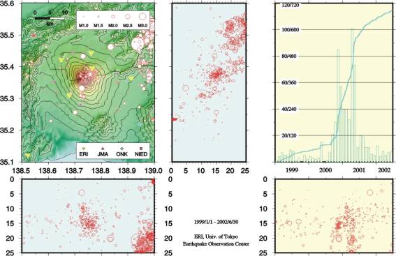
Fig. 1. Seismic activities
beneath Mt Fuji in the period of 1999-2001. The earthquakes with magnitude less than 2 are low-frequency
earthquakes and are concentrated in the depth around 15 km beneath the area
around a few kilometers northeast of the summit.
4-4-1.
Construction of seismic observation network
The main portion of the
project is to bore holes in three locations, with an average horizontal
separation of 2 km. The boring location is on the northeast slope of Mt. Fuji
(Fig.2). Each hole will have a broadband seismometer installed at the bottom,
and the deepest hole, more than 650 meters deep, will have a seismometer
installed at a mid-way point as well. These four seismometers will form a
three-dimensional array for monitoring earthquakes (Fig.3). With this set-up,
it is expected to detect the direction from which the low-frequency earthquakes
are being generated with little interference from undesired noise. At present,
two of the borehole drillings have been completed, and seismometers have been
installed at their bottoms (Fig.4).
The obtained data at these stations are sent to the station located at
the northern foot of Mt Fuji by radio, and are sent to ERI by cable.
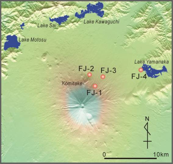
Fig. 2. Locations of boring
sites. Three boreholes, FJ-1 to
FJ-3, are designed to form an underground array of seismometers.
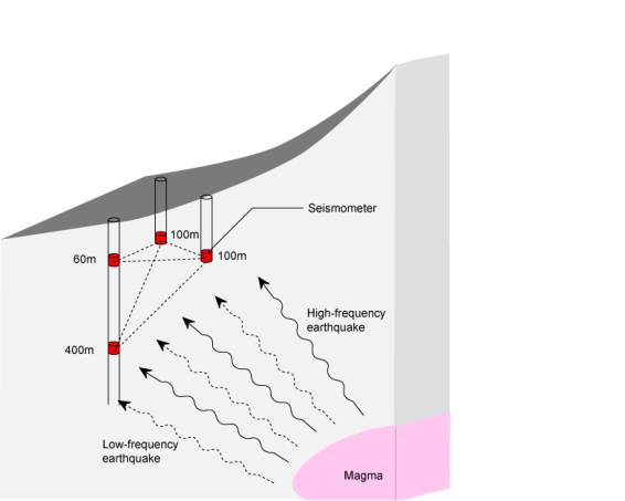
Fig.3.
Schematic view of the three-dimensional seismometer array. Broadband seismometers placed at four points
within the bore holes are designed to form tetrahedron, allowing to detect
precisely the source area of low frequency earthquake.
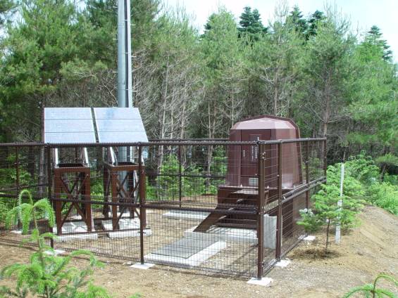
Fig. 4. A seismic station
constructed at the site FJ-2.
4-4-2.
Study of volcanic history
The core samples extracted during boring will be
analyzed to understand the past volcanic succession. As Mt. Fuji is a young
volcano and it is only 300 years from the last eruption, it is not dissected
deeply enough to study the older geologic section of the volcano. By studying
the core samples, detailed eruption sequence before human recorded history will
become available. In addition to the three boreholes mentioned above, another
hole was bored near the Lake Yamanaka to examine the tephra layers deposited
east of Mt. Fuji. It will provide reference samples because most of tepha have
been deposited eastern area of the mountain carried by the west wind which
blows almost through the year. Within a borehole of 75 meters in depth, a
tephra sequence of these 25000 years has been recovered.
In Fig. 5, a part of the borehole samples are
described. This boring site is located at the elevation of 1400 m above sea
level. At a relatively shallow portion, we can detect the unconformity between
the Older Fuji (Ko-Fuji) and the Younger Fuji (Shin-Fuji). Another interesting
feature within this section is the presence of pyroclastic flow deposit. On the
charcoal recovered from this deposit,
14C age was determined to be around 3500 yrs BP. Until recently, several
pyroclastic flow deposits of around 3000 yBP have been recognized only in the
western area. The finding of the pyroclastic flow deposit within the borehole
indicates that the pyroclastic flow could be rather common at basaltic volcano
with steep edifice like Mt. Fuji.
Another new finding is the wide compositional
variation in the ejecta of Komitake volcano, which preceded the activity of Mt.
Fuji and is buried in the edifice of Fuji volcano. After 350 m of boring,
andesite lava and pyroclastic rocks were recovered. Their compositions are
totally different from any rocks of Ko-Fuji or Shi-Fuji (Fig.6), and they
contain hornblende as a phenocryst. It has been argued that Komitake is
composed mainly of andesite lava with little compositional variation; however,
poor exposure of Komitake have prevented us to investigate the compositional
variation. The recovery of the hornblende-bearing andesite just beneath the
Ko-Fuji sequence yields chance to study the magma activity prior to the Fuji
volcano.
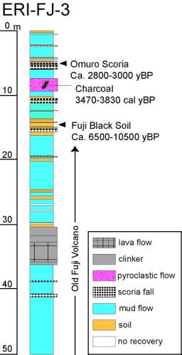
Fig. 5. Schematic description
of recovered borehole samples at the site FJ-3. Pyroclastic flow deposit
recovered at the depth of 8 m indicates the 14C age of 3500 BP.
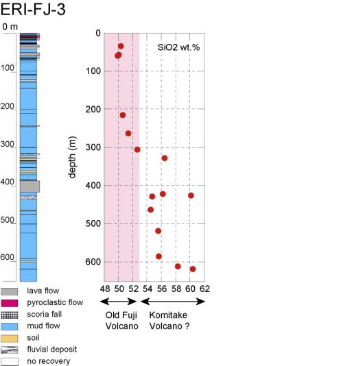
Fig.6. Schematic columnar
section at the site FJ-3 and the chemical compositions of representative
samples. The lower portion of the core is composed of andesitic rocks with
hornblende phenocryst, and is estimated to belong to the Komitake volcano which
preceded the activity of Fuji volcano.
4-4-3.
Study of volcano structure
The present project also
includes the study of seismic structure beneath Mt. Fuji by accumulating the
seismic data passing through the Mt Fuji. For this purpose, more than 70
seismic stations are incorporated (Fig.7). Almost half of them are newly
deployed by this project. Installation of such many stations within short time
was not possible without the cooperation with other national universities under
the National Research Project for Prediction of Volcanic Eruptions. Waveforms
recorded at several stations for one low frequency earthquake are shown in Fig.
8.
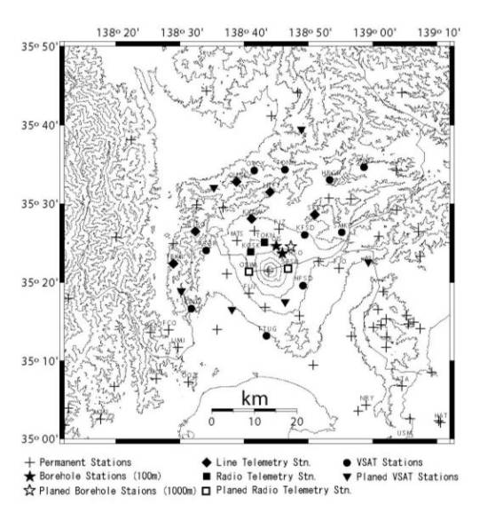
Fig. 7. Dense seismic
network around Fuji volcano.
Twenty stations including two borehole stations have been operated since
June 2002. Additional twelve stations are planed to be deployed around the
volcano in 2003.
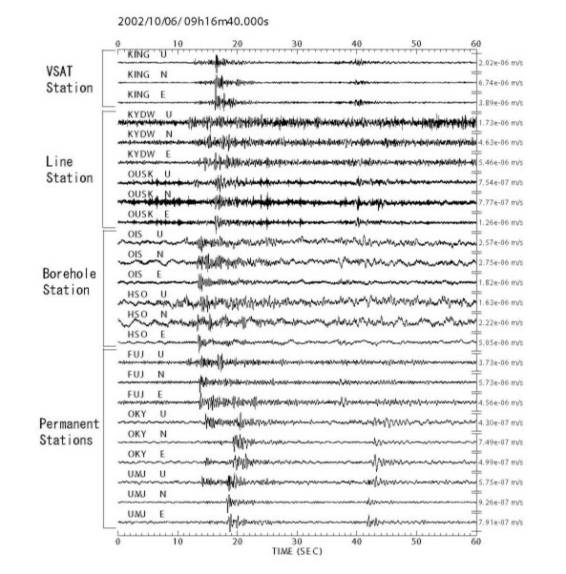
Fig. 8. Waveforms of a
low-frequency earthquake recorded at several stations deployed by this
project. The magnitude is 1.6 and
the focal depth is 16 km beneath Mt. Fuji.