5-9. Applications of GPS to
Crustal Dynamics Research
The Global Positioning System (GPS) is a powerful tool to monitor
crustal deformations of a variety of scales. The technique has been widely used
in Japan in various geodetic and geophysical researches. Earthquake Prediction
Research Center of ERI serves as the headquarters of the Japanese University
Consortium for GPS Research (JUNCO) to promote both domestic and international
cooperative GPS projects. There are three major activities under this project;
1) Construction of GPS permanent array in the western Pacific and East Asia for
monitoring plate motions and their interactions. This part of the project is
cooperated with the Ocean Hemisphere Project (see 4-3)). 2) Monitoring the
deformation process around the active faults and focal areas based on dense GPS
arrays. Dense GPS array is indispensable for estimating slip distribution on
the fault surface. For instance, post-seismic recovery of the 1995 Kobe
earthquake was monitored with a dense GPS array. Also, a GPS array was used in
the Ito area for imaging upward migration of dyke. 3) Other fundamental
researches such as application of real-time kinematic survey and virtual
reference station are.
In addition to the above major observational projects,
numerical analyses using both JUNCO and nationwide network (GEONET of GSI) data
have been promoted. An example shown in Fig. 1 is the stress increment in the
recent three years estimated from GEONET data using a stress inversion method.
This result delineates heterogeneity of the crust in terms of maximum shear
stress. Its spatial variation is compared with shallow seismic activity of the
same time period and the consistency between them is indicated.
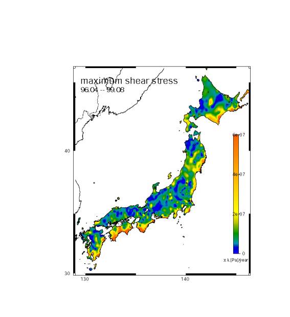
Fig. 1: Distribution of maximum shear stress change rates over the Japanese islands derived from GEONET data.