6-6) Earthquake Observation
Center
The Earthquake Observation
Center was established by integrating the observation divisions, the earthquake
prediction observation center and the observatories when the Earthquake
Research Institute was reorganized in 1994. At present, the center is composed of the four observational
research groups for earthquakes, crustal movements, and strong motions. The center has ten observatories and
the large-scale regional observation networks covering the districts of
Kanto-koshin'etsu, Kii Peninsula, Shikoku, and the western Seto inland sea
regions. The center, in order to
approach earthquake prediction and disaster mitigation, has been actively
conducting observational researches to clarify the mechanisms and the processes
of earthquake generation, and has been developing observational techniques and
instruments. The Earthquake
Observation Center has been also conducting the collaborative observational researches with
universities and other related institutions to promote earthquake-prediction
program.
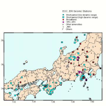
Earthquake Research Group
Seismic activities, rupture processes
of earthquakes and heterogeneous crustal structures have been investigated
using the high-sensitivity seismic networks of more than one hundred stations
covering the areas of Kanto-koshin'etsu, Kii Peninsula, and western Seto
inland(Fig.1).
Fig.1. Map of
the seismic stations of the Earthquake Observation Center.
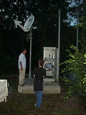
A data telemeter system utilizing a
satellite has been developed and has been in operation since 1996, which has
ensured to establish a real-time transfer of a huge amount of earthquake
waveform data. The data telemeter system has been also effectively utilized in
mobile seismic observations(Figs.2,3).
Fig.2.
Satellite dishes at the ERI hub of the satellite seismic telemetry system.
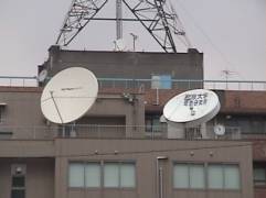
Fig.3. A VSAT
station of the satellite seismic telemetry system.
The Earthquake Observation Center is
responsible for the cooperative researches using the satellite-telemeter system.
Earthquake swarms, having repeatedly occurred off the East coast of the Izu
Peninsula, have been intensively studied to clarify the mechanisms using the
dense network of land stations and the optic-cable linked ocean-bottom
seismometer network system that was deployed in 1994. The Earthquake
Observation Center has been the responsible organization since 2002 for the
extensive researches composed of the well-organized seismic
refraction/reflection profiling and the seismic studies with an off-line dense
array in Tottori-Shimane area.
Marine Earthquake Research
Group
Marine Earthquake Research
Group has researched crustal deformation processes, heterogeneous structures
and earthquake activities in the sea and the plate boundary region using the
optic-cable linked ocean-bottom seismic stations and tsunami stations and
pop-up ocean-bottom seismometers. The cabled geophysical observation systems
are deployed off Sanriku, Tohoku district and off Ito, Izu district. Moreover, seismic activities and
heterogeneous structures around Japan have been studied with using a pop-up
ocean-bottom seismometer (OBS) array system.
1. Optical Fiber Cabled
Ocean Bottom Seismometers and Tsunami Gauges
The crust off the eastern
Izu Peninsula has had many earthquake swarms estimated to be results of magma
activities. Observations just above the earthquakes swarm are essential for a
detailed study of seismic activities. The earthquake Observation Center
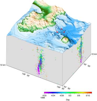
deployed a cabled OBS network system in the swarm area in 1994 (Fig.4). Data
from three sensors at sea floor are transmitted on-line by using optical fibers
to a land station. Precise location of microearthquakes has become possible
using the data from the cabled OBSs.
Fig.4.
Positions of the cabled OBS system and seismicity near the cabled OBS
system (April 20th - May 11th, 1998). Colors of dots denote origin times of
events.
The Pacific plate is
subducting beneath the Japan islands from the Japan Trench and the plate
boundary has generated destructive earthquakes in past. In 1996, an ocean
bottom geophysical observatory using sea floor optical fiber cable was
installed off Sanriku, northeastern Japan to observe earthquakes and tsunamis
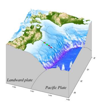
as a part of the Earthquake Prediction Program of Japan (Fig.5). The system has
three ocean bottom seismometers and two tsunami gauges. The data from sensor
are transmitted to Kamaishi land station by a sea floor optical fiber cable in
real time. The sea floor optical fiber cable is buried in area where the water
depth is less than 1,000m. The system provides an integrated observation in
land and sea for earthquake prediction. A real-time monitoring of earthquakes
and Tsunamis in marine area plays an important role in studies of plate
subduction dynamics.
Fig.5.
Position of seismometers and tsunami gauges of the cabled ocean bottom
geophysical observation system and route of the sea floor optical fiber
cable. Circle and triangle indicate ocean bottom seismometer and tsunami
gauge, respectively.
2. Marine seismic
observations using pop-up type long-term ocean bottom seismometers
Seismic observation in
marine area is important to research earthquake activity and heterogeneous
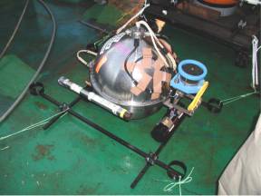
structure around Japan. The high-quality pop-up ocean-bottom seismometers with
the life of more than one year continuous recording have been developed
(Fig.6). From 2000, long-term
ocean bottom seismic observations have been carried out in plate boundary
regions and back-arc basins using the newly developed ocean bottom
seismometers. Temporal variations of earthquake activities and heterogeneous
structure of deep regions are expected to be revealed by these observations.
Fig.6.
Newly developed high-quality pop-up ocean-bottom seismometer with a
recording period of more than one year.
3. Studies of heterogeneous
structure using pop-up type ocean bottom seismometers
Some important regions in
Earth sciences such as a plate boundary are under the sea. For example,
detailed seismic structures in seismogenic zones are important information to
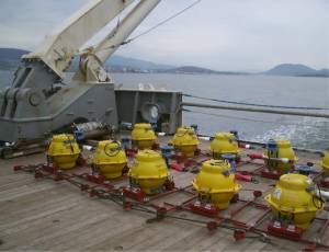
study the earthquake generation mechanism. We have performed seismic
experiments using ocean bottom seismometers, a hydrophone streamer and
controlled sources to obtain heterogeneous seismic structures (Fig.7). The
seismic experiment has been also carried out in back arc basins, ocean basins and
ridge areas to understand plate dynamics. A seismic structure survey around a
volcanic island was carried out in cooperation with the research group of
volcano in Japan in 1999.
Fig.7.
Ocean bottom seismometers and
airgun (energy source, behind OBSs) on a research vessel for a seismic structure
survey.
Crustal Movements Research
Group
Crustal dynamics and relationship between crustal movements
and earthquake occurrence have been investigated by using data obtained from
observation stations monitoring continuous crustal movements, and EDM and GPS
array stations, together with groundwater measurements. Multi-component borehole
observation instruments have been developed and enabled us to record six
components of strain, two components of tilt, temperature, and three components
of seismic waves. They are
equipped with a newly developed gyro for positioning the instruments when
installed in deep boreholes. They
have been deployed at areas where earthquake swarms occur and next destructive
earthquakes may occur in the future as Kanto-Tokai and Nankai areas, being
installed in deep boreholes at depths from 150 m to 800 m. The single frequency
GPS system is newly developed to realize the dense observation. It is enough
low power consumption and light weight for out-door observation. Since
September, 1997, dense GPS network was constructed in Ito City. Our network
detected the crustal deformation when the swarm activity became high in April,
1998. Mobile GPS observation by using this new system makes come true in 1999
Chi-Chi Earthquake and 2000 Tottori-ken Seibu Earthquake.
Precise and continuous measurements of sound velocity are carried out
at the vaults of Aburatsubo (Kanagawa, central Japan), Kamaishi(Iwate,
northeastern Japan) and Mizunami (Gifu, central Japan) by using an accurately
controlled pulse transmission method. The highest resolution of the sound
velocity is 100 ppm, 1 ppm and 10 ppm for Aburatsubo, Kamaishi and Mizunami,
respectively. The reliability of the estimated sound velocity depends on the
system clock (0.01 ppm/yr). This method has an advantage that the long-term
reliability in the temporal variation of the sound velocity should be
fundamentally the same for short-term one. Gradual change in the stress state
and water content in rocks can therefore be estimated by the monitored sound
velocity change.
Strong Motion Research
Group
Major objectives are: (1) to understand the generation and
the propagation of strong ground motions from large earthquakes through strong
motion observations at rock sites surrounding Suruga Bay where a large
earthquake of M8 is anticipated and Izu Peninsula regions, and (2) to evaluate
the effects of surface geology on strong motions using the array observation
data at Ashigara valley (Figs.8,9). A quasi real-time information system for
strong ground motions is under development. This system will focus on
dispatching additional data that will allow a local government or other
organization to respond quickly. The group collaborates with the Division of
Disaster Mitigation Science.
Fig.8. Strong motion observation network of the Earthquake
Observation Center in the Kanto-Tokai area plotted on the geological map by
the Geological Survey of Japan.
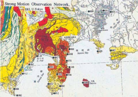
Fig.9. Array strong motion observation in Ashigara valley.

Fig.10 Wakayama
Seismological Observatory
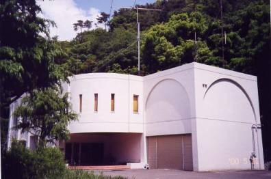
Fig.11 Local seismic observation network in the Kii
peninsula operated by the Wakayama Seismological Observatory.
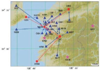
Fig.12
Hiroshima Seismic Observatory
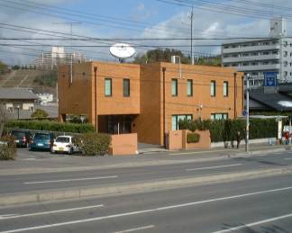
Fig.13
Shin-etsu Seismological Observatory
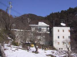
Fig.14 Nokogiryyama Geophysical Observatory:
Watertube tiltmeter and extensometer (center), the inside view of the
observation vault (right lower), and the entrance of the observation vault
(left upper).
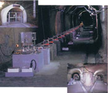
Fig.15 Fujigawa Geophysical
Observatory
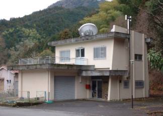
Fig.16 Okuyama observation vault, Fujigawa
Geophysical Observatory