6-9)Ocean Hemisphere
Research Center
Ocean
Hemisphere Research Center (OHRC) is the newest component of Earthquake
Research Institute. This center carried out 6-year project "Ocean
Hemisphere Network" to build a global multidisciplinary geophysical
observation network in the Pacific hemisphere consisting of seismic,
geoelectromagnetic, and geodetic observations, and further operate to
understand the structure and dynamics of the Earth’s deep interior. Studies are
intensively made by using the observation network, not only by the staffs of
this center but also scientists from other institutes and departments both of
University of Tokyo and of other Universities. This center works as a data
center that distributes the data in the international science community and
makes as complete a database as possible by data exchanges with other
geophysical networks.
In
recent years, dynamic nature of the Earth's interior is recognized as a result
of various interactions. It is necessary to have an observation network of
global scale in order to totally understand the physical phenomena on and
within the Earth. From this view point, ocean, which covers about 70% of the
Earth's surface, can be regarded as a window to look into the Earth's interior
without disturbance by complicated geological noises of the continental crust.
At the same time, ocean, especially the Pacific that is the largest on the
globe, prevents us from building geophysical observation stations. In fact
there have been few attempts to construct a geophysical network in the Pacific
due to various kinds of difficulties. In "Ocean Hemisphere Network,"
largest efforts have been paid to build a well-spread seismic, geomagnetic and
geodetic networks in the Pacific to investigate the structure and dynamics of
the mantle and the core and to reveal the physics of the Earth's activity.
There
are four major activities of this center as follows.
(1) Observation and maintenance of the seismic, geomagnetic and
geodetic networks. Since most of long-term observation stations are built on
islands in the Pacific, their maintenance requires a collaboration between
institutions. A temporal array study, either on land or on ocean bottom, will
be done to support the network observations.
(2) Development of new instruments and sensors. It is obvious that
stations on islands are not sufficient to build a network of ideal
configuration. Long-term seafloor stations for seismic and magnetic
measurements are going to be developed to overcome this problem. A borehole
seismic sensor will be developed to make a high-quality seismic observation on
seafloor.
(3) Data
analysis and study on the structure and dynamics of the Earth's interior.
(4) Data distribution and exchange. Data center pays a large effort to
distribute data to as many scientists as possible not only in Japan but also in
other countries, so as to make a sufficient contribution to the international
scientific community.
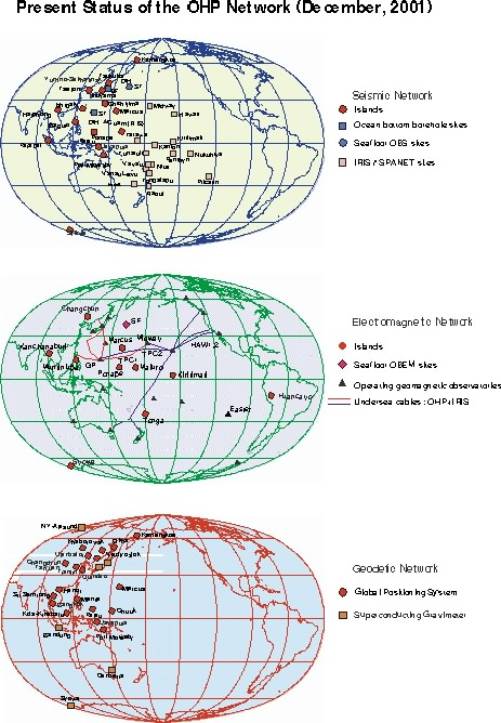
Fig. 1. (Top) Ocean hemisphere seismic observation
network. (Middle) Ocean hemisphere geomagnetic and geoelectric observation
network. (Bottom) Ocean hemisphere geodetic observation network.
|
Site name |
Code |
Geographic Lat. |
Geographic Lon. |
Associ. Inst. |
Operation |
|
Huancayo |
HUA |
-12.06 |
-75.20 |
IGP |
1997/07- |
|
Kiritimati |
KTM |
2.05 |
-157.50 |
NASDA |
1997/08- |
|
Ponape |
PON |
7.00 |
158.33 |
PATS |
1997/03- |
|
Changchun |
CHC |
43.90 |
125.30 |
China Seismological Buleau |
1998/07- |
|
Tonga |
TNG |
-21.10 |
-175.10 |
MLSNR . Tonga |
1999/09- |
|
Marcus |
MRQ |
24.18 |
153.58 |
JMA |
2000/09- |
|
Muntinlupa |
MNT |
14.40 |
121.0 |
NAMRIA |
2000/12- |
|
Majuro |
MJR |
7.10 |
171.20 |
Island Eco. |
2001/03- |
|
Kanchanaburi |
TLD |
14.00 |
98.50 |
Mahidol University |
2002/03- |