HAKONE VOLCANO, Central Japan
(Kamiyama 1,438 m, 35o13'48"N, 139o01'26"E )
(8/08/2001)
Seismic activity had been elevated at Hakone since late June 2001, being associated with small extension by GPS and small changes in tilt and strain meters. JMA commented on the August 7 afternoon that the present observation data might not indicate an urgent state of volcanic eruption. According to them, events with high seismic activity occurred previously in this volcano without any volcanic eruptions, and no volcanic tremor had been observed as of early August.
The hypocenters are shallower than 5 km under the area from Owakudani (hydrothermally active area near the center of caldera) to the southern flank of Komagatake (one of central cone) (see Figs. 1 and 2). Small quake swarm is also under the northern end of the Ashino-ko (caldera lake). On July 21, a large earthquake (M2.9) took place. Low frequency earthquakes that were also observed in 1987 and 1992 occurred in the depth of 20 to 23 km on July 22, following the same events of this May and June. According to Geographical Survey Institute, the swelling centered at Hakone had continued since late June; 1.5 cm NE-ward lateral movement and 2 cm uplift at the Hakone GPS station (near Owakudani). GPS data from more than 5 stations surrounding Hakone volcano also suggest inflation of this volcano. JMA said that the inflation source calculated by the Mogi (point source) Model is as deep as 7 km. The surface manifestation was not detected clearly.
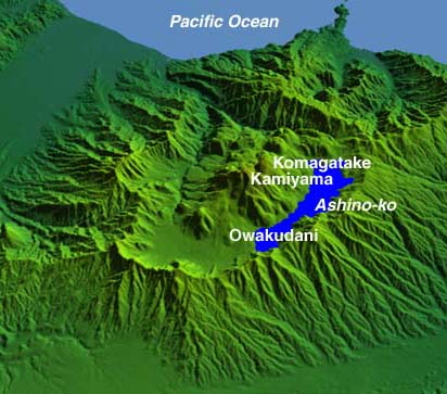
Fig. 1 Topographic image (bird-view from NW) of Hakone volcano
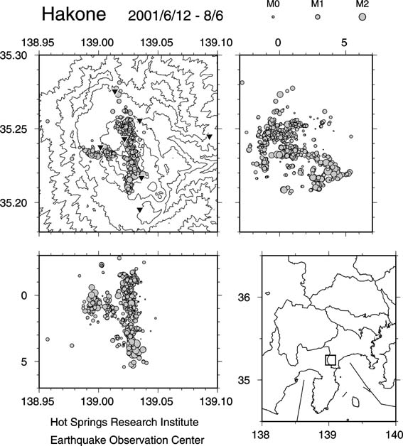
Fig. 2 Earthquakes in Hakone during middle June-early August. Triangles are seismic stations of Hot Springs Research Institute of Kanagawa Prefecture (HSRI). Hypocenters were determined precisely by Earhquake Research Institute (ERI), Univeristy of Tokyo. Those located above the surface are due to uncertainty of a used subsurface structure. Courtesy by Shun'ichi Sakai.
Seismicity of the volcano is monitored by Hot Springs Research Institute of Kangawa Prefecture (HSRI), telemetered to ERI, University of Tokyo and JMA; GPS measurement by Geographical Survey Institute and HSRI; tilt change measurement by HSRI; and wells' water level and temperature measurements by HSRI; and volume-strain measurement by JMA and ERI.
Information contact: Masaaki Churei, Volcano session of JMA. Shun'ichi Sakai, ERI, University of Tokyo
BACKGROUND
Hakone is a stratovolcano with the double caldera (about 10 km across) and central cones of andesite domes (Kamiyama, Komagatake etc.). Volcanic history of this volcano starts about 500 ka, and pumice-flow eruptions about 200 and 60 ka generated two times of caldera collapse. The latest eruption was phreatic one that occurred in the NW slope of the Kamiyama dome about 3 ka. Debris avalanche generated by this eruption flowed into the caldera floor and dammed river water, resulting in the formation of the Ashino-ko (a caldera lake). The Owakudani area that is the explosion crater of 3 ka shows a high geothermal activity. Hakone is the most famous hot spring resort near Tokyo.
To eruption menu