HOKKAIDO-KOMAGATAKE VOLCANO, SW Hokkaido
(42o04'N, 140o42'E)
(11/12/98)
Geologists of Hokkaido University and Geological Survey of Japan (Hokkaido Branch) surveyed ash deposits of the 25 October eruption the next day, and examined the ash under the petrological microscope. Their report on 28 October showed that mass of the deposits is several thousand tons, smaller than that of the 1996 eruption (roughly 12,000 tons). The ash consisted of rounded older (altered) rock-fragments (andesite), minerals and clay, without any fresh lava fragments indicating contribution of new magma. They concluded that the eruption was phreatic one as well as the 1996 eruption.
Information contact: Tadahide Ui, Graduate School of Science, Hokkaido University, e-mail: ui@cosmos.sci.hokudai.ac.jp
A shot of the 25 October eruption in T. Chiba homepage.
(10/26/98)
JMA issued "Volcanic Advisory" # 1 on Hokkaido-Komagatake on the 25 October morning, and three Volcano Observation Reports by the night of that day. A small-scale phreatic eruption occurred at 9:12 a.m, and issued ash up to about 1,200 m above the crater. The eruptive activity declined with time. There has been no report of injuries or damage caused by the eruption, and no evacuation order was issued.
Volcanologists surveyed the activity from a helicopter in that afternoon. They reported that the site of eruption is the crater that opened in the 1929 eruption and is the same crater for the March 1996 eruption. Ash covers an area around the crater and widely the eastern area of the crater. They said that the scale of this eruption was smaller than that of the March 1996 eruption.
Volcanic tremor for six minutes was associated with this eruption. Five volcanic earthquakes were recorded in 12 hours following the eruption.
Information contact: J. Miyamura, Sapporo District, Japan Meteorological Agency, e-mail; j-miyamura@met.kishou.go.jp
(last modified 3/8/96)
Five minutes-long volcanic tremor occurred in 18:10 JST on 5 March 1996, according to the Usu Volcano Obsevatory (UVO), Hokkaido University. More than 10 of small volcanic earthquakes occurred this day, more frequent than usual days at this volcano. Ash falling was observed on the southern flank of the volcano, more than 10 km from the summit. Local people recognized white-colored eruption plume rising from a fissure of the 1929 eruption in the night. Japan Meteorological Agency (JMA) also reported around 150 m-high white plume rising above the summit in the 6 Mar. morning. This volcano has been monitored by both UVO and JMA. No obvious precursor phenomena of this small eruption had been detected.
(last modified 3/11/96)
Volcanic tremor has not been observed since the 5 Mar. evening (as of 10 Mar. evening). Small volcanic earthquakes have occurred several times a day since 6 Mar. (UVO). The height of white-colored plume above the summit was 900 m in the Mar. 8 (JMA).
(last modified 3/8/96)
Helicopter inspection was done by geophysists and geologists, additional seismometers were installed by JMA, and EDM measurement was done by UVO. According to Tad Ui, Hokkaido Univ., who observed from helicopter during 6:30-11:00 am, 6 Mar., steam-dominate eruption clouds rose from inside craters of the 1929 eruption and also from 100 m-long, N-S trending fissures which newly formed S of the former. The height of the cloud was around 400 m. Ash fall covers new snow; no mud-flows were observed. Press and local people took videos both from helicopter and from the ground, showing violent, gray ash-laden clouds jetting out from newly-formed fissures. Residents ordered evacuation since the Mar. 5 night, partly were permited to return their home on 7 Mar, and were relieved of evaculation on 8 Mar.
(3/8/96)
A group of geologists and petrologists of Hokkaido Univ. carefully analyzed ashes and rock fragements that erupted on 5-6 May, and reported no finding of juvenile materials such as fresh vesiculated particles or pumices. Tad Ui, the leader of the group, concluded that the initial state of the present event was phreatic eruption. His group is doing field-survey of this eruption, and keeps analysis of new products. Ash falling on 5-6 Mar. was recognized 35 km SES away from the source by the JMA survey group.
(3/13/96)
The eruption activity had almost declined by 12 Mar. In the evening of this day, the Coordinating Committee for Prediction of Volcanic Eruption (CCPVE) noted that repeating small-scale phreatic eruptions may be possible advance signs of a large eruption, such as for the 1929 eruption. According to the comments, UVO found the continuous extension of the 1929 crater area since 1989. Their leveling survey in Nov. 1995 caught the change from subsidence to uplift in the mountain-side. Tephra erupted in this event was estimated to be about 25,000 ton by Hokkaido University.
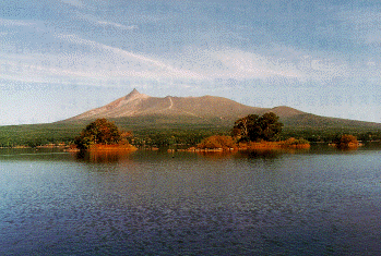 (left photo) Southern view of Hokkaido-Komagatake Volcano (taken by M. Kanemaki).
(3/6/96)
Hokkaido-Komagatake, or Komagatake (Hokkaido), Volcano is located 30 km north of Hakodate City with population of 320,000. This is an andesite stratovolcano (1,133 m high) whose summit has a 2 km-wide horseshoe-shaped caldera open to the E, resulted from large collapse 30-40 ka. Large-scale pumice-flow eruptions had occurred several times from craters within the caldera, including historical 3 major eruptions; 1640, 1856, and 1929.
(last modified 3/7/96)
In the 1640 eruption, the summit part collapsed and the avalanche entered into sea, resulting in the generation of tsunami, killing 700 people. In 1929, one-day eruption issued 0.38 km^3 of ash falls and 0.14 km^3 of pumice flows; 2 killed and 4 injured. The eruption column height was 14 km. The pumice flows descended in all directions, reached about 8 km from the summit. Major eruptions at this volcano are characterized by very short activity duration (< a few days). The latest eruption took place in moderate-scale, such that eruption column reached 8 km above, in 1942.
Link to
airphotos of eruption (7 Mar.)-T. Chiba, the mirror in MTU,
Komagatake site-Y. Hayakawa (in Japanese w/ Eng. notes),
Hakodate City Daily New with eruption photos,
and CNN news with a movie.
To eruption menu