According to USGS, an Mw8.0 earthquake occurred off the Samoa Islands in the Pacific (15.56ºS, 172.07ºW, 18km deep) at 2:48am, September 30th, 2009 (Japan Time, 6:48am, Sept. 29th local time ).
Due to the large magnitude and the shallow epicenter, there has been reports of tsunamis and deaths.
Following is a quick report of the earthquake.(Outreach Office)
[Updated]
- Website by Associate Prof. KOSHIMURA of Tohoku University added to Links
- Focal mechanism by W-phase Seismogram
- What is an ‘outer rise earthquake’?
- Earthquake waveforms observed by the Ocean Hemisphere Network Project
- Earthquake waveforms observed by J-array
- The 1933 Showa-Sanriku Earthquake
- Abstracts
- Tectonics Background
- Animation of Tsunami Propagation
- GPS Tsunami Recorder
[Abstracts]
- it is a normal fault earthquake within the Pacific plate which subducts at the Tonga trench
- it resembles the M8.1 earthquake which generated the Showa-Sanriku tsunamis on March 3rd, 1933
- about the tsunami
- since the fault stretches in the NW-SE direction, it can be assumed that the tsunami can become large, in the orthonogol direction (SW-NE)
- it is considered that a tsunami over 1m was generated since Samoa is located to the NE of the epicenter
- there is a possibility of tsunamis around a few ten centimeters hitting the coast lines of Japan, although this does not indicate that it would become larger especially at Japan within the Pacific countries
- An earthquake of M8 had happened in 1917, with a 12m tsunami. The tsunami from this earthquake had reached Japan, and tsunami of 1m was observed in Kushimoto.
[Tectonics Background]
The Tonga trench where this earthquake took place, is where the Pacific plate subducts westward beneath the Australian plate located in the west. With the epicenter at the northern most, the trench runs NW, then continues on west towards Fiji, where in the west runs the New Hebrides trench. Then at New Hebrides trench, it shows a complex tectonics with the Australian plate subducting from eastward beneath the microplates.
With the earthquake being a normal fault earthquake, it can be considered as an earthquake which occurred on the plate boundary, or an outer rise earthquake away (in this case, towards east) from the trench axis.
An earthquake of M8 has happened almost in the same area in 1917, and a 12m tsunami was observed. This tsunami reached Japan, and there remains a record of a 1m tsunami at the largest, in Kushimoto.
by Yoshinobu TSUJI and Outreach Office
[Animation of Tsunami Propagation]
With the falut streching NW-SE, there is a possibility of the tsunamis becoming large in the orthogonal direction (SE/NW). It is considered that tsunamis over 1m were generated since the Samoa Islands is located on the NE of the epicenter. This does not indicate that tsunamis hitting Japan would become especially large, in the Pacific countries, but there still remains the possibility of tsunamis of few ten centimeters reaching Japan.
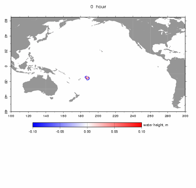
(Click to start animation)
The following shows the maximum water height of the tsunamis. It is clear that the wave is high in the direction of NE-SW.
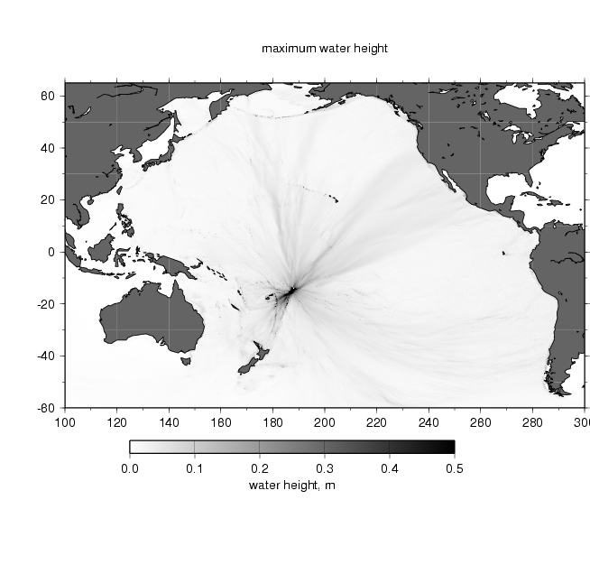
by Prof. Kenji SATAKE
[ The 1933 Showa-Sanriku Earthquake]
On March 3rd, 1933, before dawn, an M8.1 intraplate normal fault slip earthquake occurred in the Japan sea trench off the coast of Sanriku, recording an intensity of 5 in the coastal area. Tsunamis were generated 30-40 minutes later, and the wave height reached 28.7m in Ayasato, Sanriku-cho. The Number of people dead and missing reached about 2,700 in Iwate Prefecture, about 300 in Miyagi Prefecture, 30 in Aomori Prefecture, and 13 in Hokkaido. Almost 6,000 houses were washed out and/or destroyed within the six prefectures.
Within the decade since the foundation of the Earthquake Research Institute, eruptions and earthquakes such as the eruption of Mt. Tokachi, the north Tango earthquake, eruption of Hokkaido Komagatake, the Kanto earthquake, north Izu earthquake, Ito swarm earthquakes, west Saitama earthquake, and the Sanriku earthquake tsunamis occurred one after another. This initiated and created the basis of the large-scale overall research and enlightenment activities such as local investigation and open lectures for the public. As with the research/investigation results of the Sanriku earthquake tsunamis, an open lecture was held, and then was released as the additiona volume to the first issue of the Bulletin of the Earthquake Research Institute.
by Outreach Office staff, Eiji KUWABARA
[GPS Tsunami Recorder]
Records of the GPS tusnami recorders located off Muroto can be seen from the URL below.GPS tsunami recorders were developed approximately ten years ago with the aim of estimating tsunamis and transmitting information to the residents on the coast, and to mitigate tsunami disasters.
http://www.tsunamigps.com/index.html(Japanese Only)
The tsunami recorder (see image below) is a buoy floating in the ocean with a GPS (a device that determines the location accurately by receiving electric waves from the satellite) transmitting data realtime via radio to land-based stations, estimating the location in centimeters, enabling the monitoring of the sea surface height on-line.
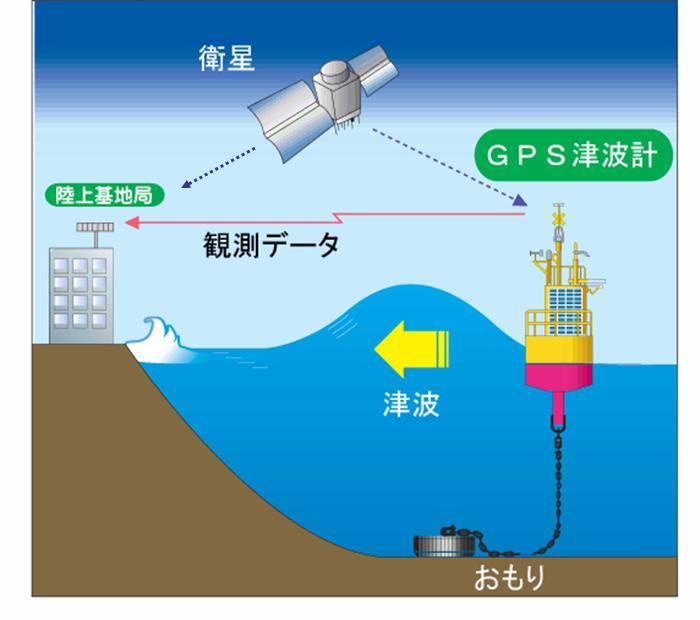
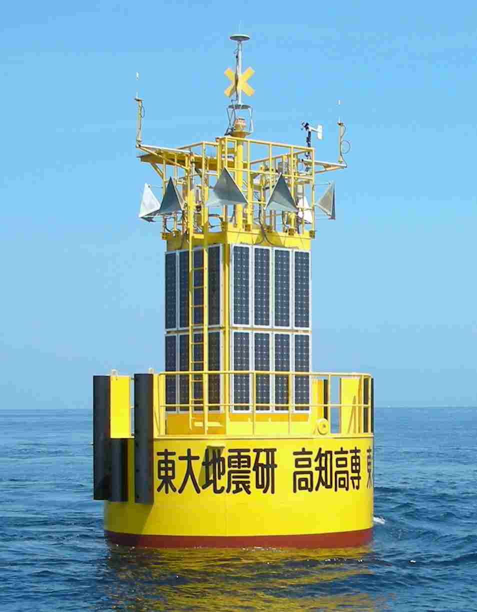
Click to enlarge
The experiment conducted at Ofunato has succeeded in detecting tsunamis generated by the Peru earthquake in 2007, and the Off-Tokachi earthquake in 2003. It is now placed offshore of Ofunato, and has also detected the tsunamis generated by the earthquake off the Kii peninsula in 2004.
With the current placement, it is possible to detect tsunamis about 10 minutes before it actually hits the shore, but we are considering of placing them further off shore, to mitigate tsunami disasters and to detect tsunamis at an earlier stage.
[Cooperate Research Institutions ]
- Kochi National College of Technology
- Tohoku University
- Port and Airport Research Institute
- Hitachi Zosen Cooperation
by Prof. Teruyuki KATO
[Earthquake waveforms observed by J-array]
Earthquake Information Center
[Earthquake Waveforms Observed by the Ocean Hemisphere Network Project]
The Ocean Hemisphere Network Project is a project to lay out a network in the pacific ocean hemisphere for overall observation of the global activities such as seismic, electro-magnetic, geodetic and crustal movements to unveil the activity of the earth in a global scale. We have achieved greatly ever since the project has been launched in 1996. Visit “Ocean Hemisphere Network Project – New Eyes to See the Interior of the Earth-” for further information.

Figure 1: Observation locations (click to enlarge)

Figure 2: Records of the seismogram. The lateral and vertical axes indicate time (one hour in the left figure and three hours in the right) and the distance from the epicenter, respectively. Left: 30 sec low-pas filtered. We can see the body waves and the surface wave., R1, which propaget the minor-arc. Right: 100 sec low-pass filtered. We can see the R1 and R2 surface waves, where R2 propagate the major-arc.
by Ocean Hemisphere Research Center
[What is an 'outer rise earthquake'?]

There is an ‘outer rise’ from the trench towards the ocean, where the land has risen, and earthquakes occurring underground of this outer rise is called an ‘outer rise earthquake’. The rise of the land is due to the subducting plate bending on the outer side of the trench, but if the epicenter is not so deep, it then becomes a normal fault slip with the tension due to the bent.
[ Focal Mechanism by the W-phase Seismogram]

strike / dip / slip
fault surface1: 152.2/ 41.1 / -87.7
fault surface 2: 329.2 / 49.0 / -92.0
by Yusuke YOKOTA (MC2)