Launched: 24th October 2011
Last Updated:11th November 2011
At 19:41(local time:13:41) 23rd October, M7.2 earthquake(USGS) stroke eastern Turkey. The hypocenter of this earthquake is 20km deep, and huge damage is expected in the big cities nearby.
At 04:23(local time:9th, 21:23) 10th November, an aftershock of magnitude 5.6(USGS) had occured, causing more damages.
All information related to this earthquake will be updated on this page.
[ Basic Information ] (compiled from USGS)
- Date and time :13:41 October, 23rd, 2011 (Local time. Japan time: 18:41am,GMT:10:41)
- Location: 38.628N, 43.486E
- Magnitude: 7.2
- Depth: 20 km
- Major cities in the area: Van(17km),Hakkari(117km) etc
[Update]
- Added a line on top about Aftershock(10th November)
- Links added (31st October)
- The waveform observed on J-array (25th October)
- List of Links (24th October)
- Tectonic Summary (23rd October)
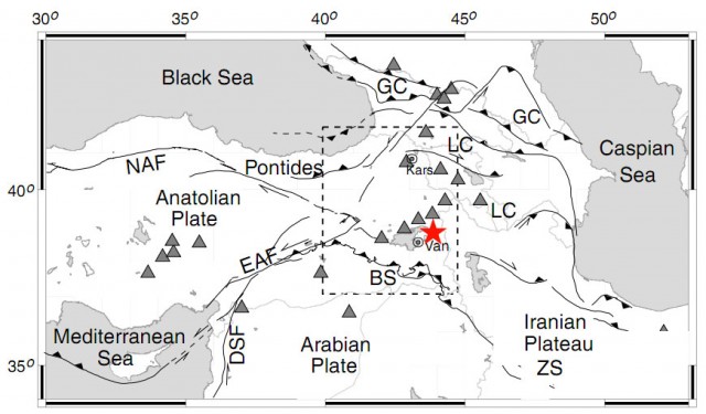
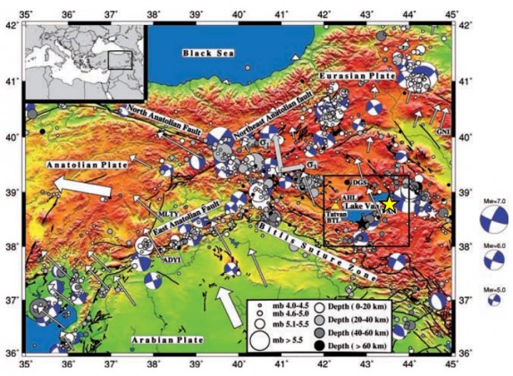
Turkey is where Eurasian Plate and Arabian Plate collides with each other and have frequent destructive earthquakes. In details, a microplate is introduced amongst the Eurasian Plate. This microplate is called Anatolian plate divided by North Anatolian Fault (NAF) which locates in the south of black sea, East Anatolian Fault (EAF) and the Mediterranean. Most of Turkey consists of this plate.
According to the location of hypocenter by USGS, the earthquake this time had occurred not in the Anatolian plate, but in the Eurasian Plate which is in the east. Most of the recent destructive earthquakes occurring in Turkey, are occurring in the North Anatolian fault (NAF in below fig.), but this time, it wasn’t.
*NAF stands for North Anatolian Fault and EAF stands for East Anatolian Fault.

tectonics of the eastern Turkey tectonics. the star on map indicates the hypocenter. (added on Angus et al.,2006)
In 1976, there was an earthquake of M7.3 magnitude, and killed more than 4000 people.
(Outreach and Public Relations Office: Dr.Oki, Dr.Koketsu)
Waveform of the earthquake in eastern Turkey, October 2011
(Earthquake and Volcano Information Center)
- USGS:Magnitude 7.2 – EASTERN TURKEY
- International Institute of Seismology And Earthquake Engineering, Building Research Institute:2011/10/23 Eastern Turkey Earthquake
- Strong ground Motion database of Turkey
- METU:Earthquake Engineering Research Center
- Strong Ground Motion Database of Turkiye
- Plan for Strong Ground Motion Database of Turkiye(in Turkish)
- PROCESSED MAINSHOCK ACCELEROMETRIC RECORDINGS OF THE 23 OCTOBER 2011 VAN EARTHQUAKE(PDF)
- Overall Report
- Overall Report (in Turkish)

