Preliminary report
on eruption at Anatahan Volcano, Northern Mariana Islands
(updated 31
July 2003; posted on 25 July 2003)
Earthquake
Reserach Institute,
University of Tokyo,
Institute
of Seismology and Volcanology (SEVO), Kyushu University, and
Emergency
Management Office (EMO), CNMI
The erutpion
activity that started on May 10 has been monitored devotedly and
continuously by EMO and USGS. We had a chance to carry out geological
inspection together with GPS installation on this volcano during
16-19 July 2003. This is the preliminary report of gelogical
inspection and the following analysis. We hope that this report and
photos are of much help for understanding of the present eruptive
activity at Anatahan.
|

|
|
|
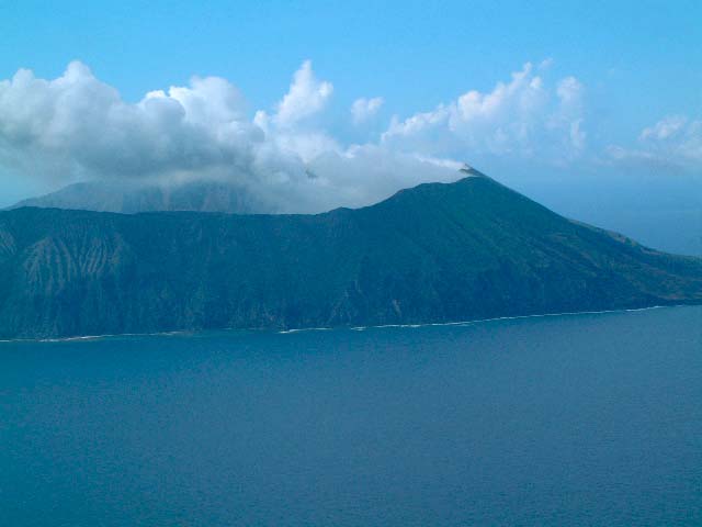
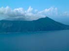
Fig. 1 S view of the eastern part of the
Anatahan Island. The active crater (E caldera) is under the
cloud. Taken by S. Nakada on July 18, 2003.
|
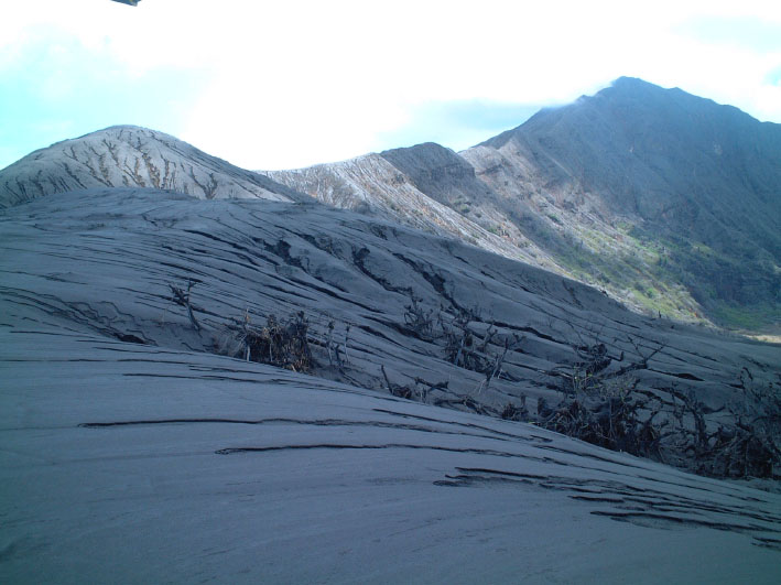
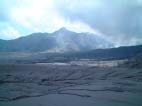
Fig. 2 Southern rim of W caldera: thickly
covered with new tephra. Taken by S. Nakada on July 19,
2003.
|
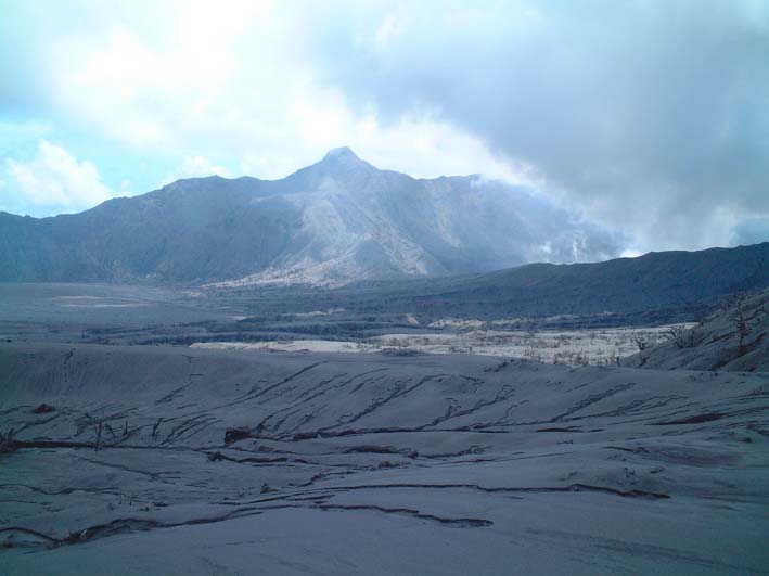
Fig. 3 Inside W caldera, facing to the
active crater that locates in E caldera (crater). Taken by
S. Nakada on July 19, 2003.
|
|
|
|
|
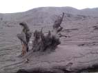
Fig. 4 Caldera floor just south of the
active crater. Taken by S. Nakada on July 18, 2003.
|
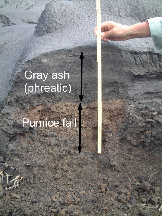
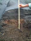
Fig 5 Section of tephra just south of the
active crater. Pumice fall deposits is covered by multiple
thin layeras of gray ash of phreatic eruptions. Original
image was taken by S. Nakada on July 18, 2003.
|
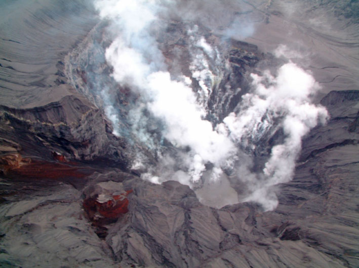
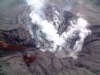
Fig. 6 SE view of steming active crater.
Dry mud pool is at bottom. Taken by S. Nakada on July 19,
2003.
|
|
|
|
|
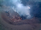
Fig. 7 NW view of the active crater. Bloken
lava dome (?) is inside the crater. Pyroclastic cone
developes, surrounding the crater. Taken by S. Nakada on
July 19, 2003.
|
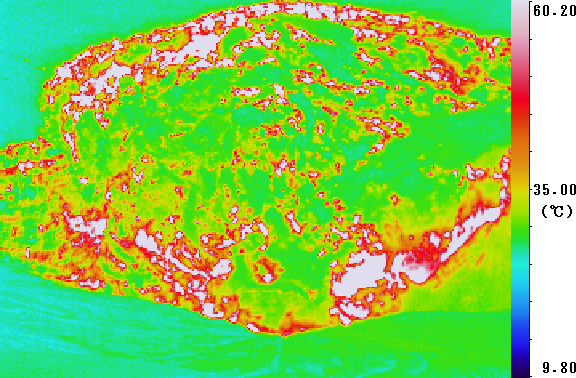
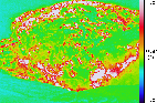
Fig. 8 Infrared camera image of the active
crater, taken from S-rim of the crater. Taken by T.
Matsushima on July 18, 2003.
|
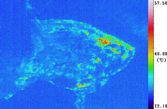
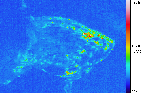
Fig. 9 ibid, taken from E. Reddish parts in
upper right represent the remnant of lava dome. Taken by T.
Matsushima on July 19, 2003.
|
Introduction
Anatahan Volcano erupted on the
evening of May 10, 2003 (for detail, see USGS-EMO
home pages). The volcano has
no historical document of eruption. It is important to investigate
why the volcano erupted at this time from the standpoint of tectonics
and volcanology. Moreover, we have to monitor its activity how the
eruption proceeds and when it ceases its activity, from the stand
point of hazard assessment and reduction in the CNMI region.
Our team together with EMO staff has
made GPS measurements since 1998, succeeding the old effort by John
Beavan and his colleagues in early 1990. Repeated GPS measurements
since then have revealed clear evidence of back arc spreading of the
Mariana Trough with velocities of 4-6cm/yr. This suggested that the
Northern Mariana Islands are on restless tectonic environments. This
tectonic situation is the cause of volcanic activity in the northern
Mariana islands, including the eruption of Pagan in 1981.
(Refer to; Kato et al.,
Geophys. Res. Lett., vol. 30, 1625, 27-1, 2003)
The eruption of Anatahan provides us
with a very important opportunity to investigate the mechanism of
volcanic eruptions in these areas. This is practically important for
hazard assessment and evaluate potential eruption in other volcanoes.
Moreover, it is primarily scientifically important to investigate the
mechanism of volcanic eruption in principle.
Motivated by the above practical and
scientific goals, we planned to deploy a scientists' party to
investigate the eruption of Anatahan. Followings are the preliminary
documents for the field research done by the Japanese team.
Outline of GPS
installation and geologic survey
We established the fixed GPS site at
ANAT GPS site at Anatahan this time. Solar panel and a battery are
used for power and a small PC is used for automatic downloading of
the data. This system may allow long term continuous
recording.
Anatahan volcano during our
inspection was quiet and its activity was lowest in seismological
level. Only weak steaming was observed at the active crater.
Therefore, it is fortune that we succeeded the field inspection using
fishing boat and helicopter under these condition.
Geologic
inspection
Tephra of the present eruption
consists mainly of pumice-bearing brown ash in lower and gray fine
ash in upper (Fig. 5). The former is products of pumice (subplinian?)
eruption, whereas the latter phreatic eruption. Both furthermore
consist of many layers respectively. At the village (NW end of the
island), gray ash is totally about 3 cm thick, contrasting to about
20 cm thick for products of brown ash. Color of matrix of brown ash
resulted from high-temperature oxidation during eruption.
At the SE part of the island (new
seismic station), tephra of this eruption is as thin as less than 3
cm. Melting of plastic bottles were found and the possibility of high
temperature ash cloud was raised. However, the evidence suggesting
high temperature of ash deposit is not clear; for example, grasses
and trees do not show any damage from heat of ash.
The S outerslope of the active crater
in the E caldera is thickly covered by gray ash (Figs. 2, 3 and 4).
Many rills and gullies developed on the deposits due to
water-impermeable nature of gray ash (very fine particles), as well
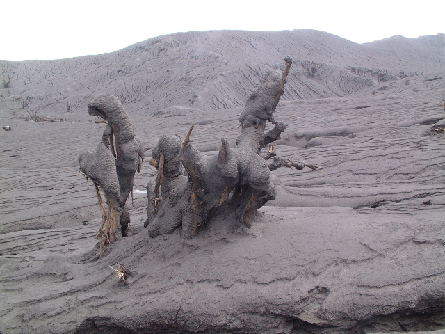
as in most parts inside the W caldera. Rare amount of partly broken
stripped trees stand on the slope and gray ash (tephra) thickly
covers them on the side facing to the active crater. Gray ash is
about 20 cm thick near the crater rim and pumice-bearing tephra below
is about 25 cm thick. The latter accumulates blocks and fragments of
pumice. Grass stems are partly burnt only near the bottom of deposits
near the crater.
Inside the western caldera, tephra is
as thick as one meter in total. Gray ash is deposited most thickely
NW of the crater, suggesting nearly lateral movement through in the
lowest part of the eastern caldera rim. Pumice-bearing tephra is
thickest in WSW direction of the crater. The latter is in harmony
with drifting direction of eruption plumes in the earliest stage,
taken by the satellite images (BGVN, April 2003). Although most of
trees had survived from pumice falling during eruption, they were
toppled down by strong lateral movement of gray ash by phreatic
eruptions.
Active crater
Only steaming was observed during two
days of helicopter inspection. The active crater is located in the
southern part of the eastern crater bottom inside the eastern
caldera, and the southern wall of the active crater is extended
directly to the wall of the eastern crater. Dimension of new crater
is approximately 300 m across and 100 m deep (deepest part in south).
Inside is rugged due to the existence of several lava blocks. A mound
like remnant of lava dome can be seen in the northen periphery inside
the crater (Fig. 7). The surface was covered thickly by gray ash of
phreatic eruption. Infrared camera image shows higher temperature of
this mound than outside the crater (Fig. 9). The dome may have been
bloken by explosive eruptions which occurred in the middle June when
active seismic and visual activity was observed (USGS-EMO report).
Neither bombs nor blocks was clearly visible on the crater floors of
both the eastern crater (outside the pyroclastic cone) and eastern
caldera. Original dimension of the lava dome may be small, because
large blocks of lava dome were not observed around the active
crater.
The deepest bottom of crater
was filled with mud pool (dried already) (Fig. 6). Infrared camera
showed the temperature as high as 300 C on July 18, but as low as
less than 100 C on July 19 (Fig. 9). Low pyroclastic cone developes
in the northern side, surrounding the crater (Fig. 7). The maximum
thickness of tephra newly deposited, exposed on a gully through
pyroclastic cone (Fig. 6), can be estimated roughly to be 20
m.
Chemistry and degassing
of magma
Pumice of this eruption is
crystal-poor and light to dark brown in color. A pumice block
collected from the pumice-fall layer, just south of the active
crater, was analyzed with XRF at ERI. The pumice fragment has light
brown crust and dark brown vesicular core, and the crust and core
parts were separately analyzed . The SiO2 contents of two parts were
identical, about 61 wt%.
Blue- to purple-colored volcanic gas
was observed and strong smell of rotted egg was felt near the south
rim of the eastern caldera on 18 July. The discolored part represents
meaty sulphur dioxide (SO2). We detected 2 - 4 ppm sulphur dioxide
gas (SO2) and 0.5 ppm hydrogen sulfide gas (H2S). SO2 gas emission
rate looked not so high throughout our field inspection; flux of
sulphur dioxide should be less than several thousand tons a day;
.similar to at Sakurajima volcano, Japan
Brief summary of
geological inspection
Ongoing eruptive event started with
pumice eruption (subplinian?) probably in middle May, such that whole
of the island was covered with brown tephra (ash) especially in the
direction WSW of crater. It is likely that, then, lava dome formed
inside the crater, though it was broken by the following events.
After an erosion hiatus, strong phreatic eruptions were repeated
(probably in middle June). Phreatic eruptions issued gray ash, which
was deposited mainly inside the calderas but weakly covered most part
of the island. Deposition of the latter resulted in frequent
occurrence of small mud-flows after that. As the crater bottom
deepened during eruption (near sea level), interaction of magma with
water, invaded from the interior of the volcanic body, might have
triggered destructive phreatic explosions. Detail time relation
between eruptions and modes of eruptions should be investigated
carefully hereafter.
Information
contact:
Setsuya Nakada, Volcano Research Center, ERI, Univ. Tokyo,
nakada@eri.u-tokyo.ac.jp; Teruyuki Kato, ERI, Univ. Tokyo,
teru@eri.u-tokyo.ac.jp; Takeshi Matsushima, Institute of Seismology
and Volcanology (SEVO), Kyushu Univ., mat@sevo.kyushu-u.ac.jp; Ray
Chong, EMO, CNMI, rcchongemo@hotmail.com; Juan T. Camacho, EMO, CNMI,
juantcamacho@hotmail.com
Return