Hachijojima, Izu-Mariana
Islands
Nishiyama 864m, 33o08'00"N
139o48'09"E
(09/04/02)
Hourly number of earthquakes has been less than 10 in the late
August. The ground deformation on Hachijojima island, detected by GPS
of Geographical Survey Institute, was being recovered to the previous
state. JMA reported on August 27 that very long-period signals
sourced near Hachijojima volcano were observed widely in the southern
coast of Honshu (Tokai and Kanto districts). These were detected by
broad-band seismometers, tilt-meters and strain meters. The
hypocenter of a high-frequency earthquake preceded by a very
long-period signal was located NW offshore of the volcano.
(08/21/02)
According to JMA, the seismic activity around Hachijojima volcano had
decreased. Hourly numbers of earthquakes since the August 20
afternoon had kept less than 10. Hypocenters of them had moved to NW
from the first place of earthquake nesting. The migration direction
(NW-SE) is roughly in parallel to the long axis of the island.
However, low-frequency earthquake events occurred in early moring and
evening of this day; the hypocenter of the latter event was located
near the first swarms of Aug. 13-15.
(08/17/2002)
The seismic activity began to decrease in the Aug. 16 evening: since
then, hourly numbers mostly less than 20 (JMA data). JMA installed
two seismometers temporally in the island this day. JMA released the
news on the volcanic activity at Hachijojima volcano on the Aug. 16
evening. The comment said that the present seismic activity might not
lead directly to eruption, though it may continue a little while in
this level. Simultaneously the Geographical Survey Institute reported
the GPS measurement result on the present activity; the GPS station
located in the center of the island had migrated 5-6 cm to E, and had
been uplifted by 10 cm till 3 p.m. on Aug. 16.
(08/16/2002)
High seismic activity had continued at Hachijojima volcano. Volcanic
tremor-like waveforms were also included. According to JMA, the
hourly number of erthquakes had been over 20 since the Aug. 13
evening: the peak was about 250 on the Aug. 15 morning. Cumulative
number of felt-quakes amounted to 22 as of 3 p.m., Aug. 16.
 Hypocenters of volcanic earthquakes during
August 13 to 15 (as of 20:00, Aug. 15).
Hypocenters of volcanic earthquakes during
August 13 to 15 (as of 20:00, Aug. 15).
Sites of seicmic stations are shown on the map in the upper left.
Courtesy of S. Sakai (ERI, U-Tokyo).
Information
contact: Dr. Shin'ichi Sakai
(Earthquake Research Institute, University of Tokyo);
coco@eri.u-tokyo.ac.jp
(08/15/2002)
JMA repeatedly reported the seismic activity in Hachijojima volcano
since the August 13 evening; seismic swarms began in the Hachijojima
island at about 4 p.m., August 13 (JST). As of 5 p.m., August 15,
totally 16 felt-quakes were observed. The maximum magnitude reached
3.0 on August 15. The hypocenters locate about 2 km off the western
shore in the central part of the island, and in the depth 15-5 km,
depending on assumed seicmic-wave velocity models. They started to
migrate to N, to the direction of Mt. Nishiyama on the August 15
morning, being deepened.
Five seismic stations of Tokyo
Metropolitan Government, JMA, and National Research Institute for
Earth Science and Disaster Prevention (NIED) had been settled on this
island.
Information
contact: JMA, H. Yamasato;
yamasato@met.kishou.go.jp
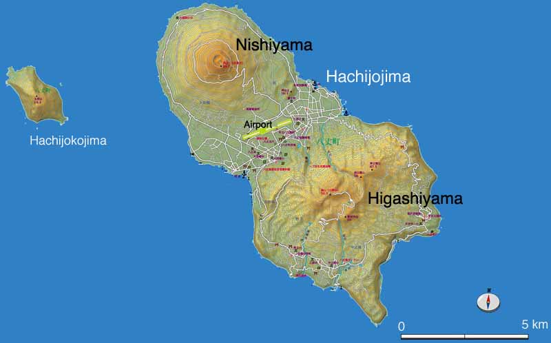
BACKGROUND
Hachijojima is a basaltic volcanic
island elongated in NW-SE, a gourd-shape of 14 km long and 7.5 km
wide, about 290 km south of Tokyo. Two stratovolcanoes, Nishiyama
(younger than 10, 000 years ago) and Higashiyama (30,000 to 4, 000
years ago) in NW and SW respectively, are comprised of this island.
Small eruptions were recorded in 1487, 1518, 1522-23, 1605 and 1606,
though the eruption sites were not known clearly. Seismic swarms
occurred in 1690-91 and 1697-98.
The population in this island is about 9,200. They are living mainly
in a lowlands of a saddle between two volcanoes and partly in the
southern slope of Higashiyama.
 Map of Hachijojima
Return to menu
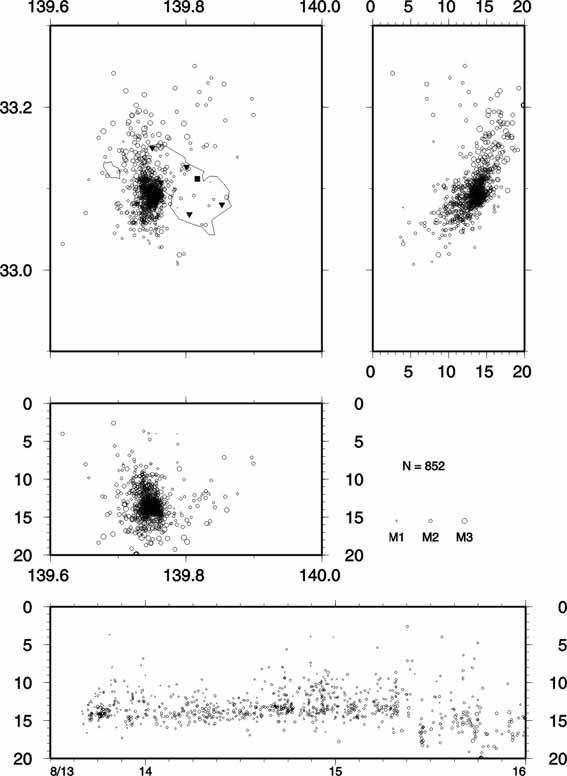 Hypocenters of volcanic earthquakes during
August 13 to 15 (as of 20:00, Aug. 15).
Hypocenters of volcanic earthquakes during
August 13 to 15 (as of 20:00, Aug. 15).