IWATE (IWATESAN) VOLCANO, HONSHU (NE-JAPAN)
(2,038 m, 39o 50' 59" N - 140o 00' 16" E)
(11/17/99)
The extended National Coordinate Committee for Prediction of Volcanic Eruptions was held in the city of Morioka, Iwate Prefecture, on the evening of 16 November. The comments were as follows;
"Large tremor for about four minutes (M2.1) occurred at 20:54, 12 November 1999. A swarm of volcanic earthquakes was associated during and 2 hours after the tremor event. The hypocenter of the swarm located 2-3 km below the Ubakurayama and Kurokurayama area, west-Iwate. This tremor is similar in shape, amplitude and duration to that (M2.4) on10 July of last year, so that the event likely occurred in the similar place to the site for the latter event. Changes in tilt-meters and strain-meters in the volcano flank detected during the tremor event can be understood due to faulting or fluid movement under the ground. After the event, however, no following changes were observed in these instruments. GPS distance traversing the volcano in N-S and fumarole temperature in the Ubakurayama-Kurokurayama region had not changed before and after the event. The surface manifestation of the event was not clear in the 12 November night, though the inspection from the helicopter in the next morning showed neither major change in fumarole activity nor deposition of new volcanic ash.
Fumarole activity in the west-Iwate has increased since this May, such as increasing in amount, area, and frequency of steaming since this October. The number of shallow earthquakes has increased in the Ojigokudani area (erosion caldera of the west-Iwate). The occurrence of the tremor event this time still suggests a possibility of phreatic explosion in the west-Iwate."
(11/16/99)
JMA issued the fourth Volcano Advisory on Iwate Volcano on the evening of 12 November, as a volcanic tremor event with the instrumental saturation duration of 4 minutes occurred at 20:54 JST. The instrumentally saturated volcanic tremor is the first since 10 July 1998. The epicenter was near Mts. Ubakurayama and Kurokurayama (in west-Iwate, west of the erosion caldera). Earthquake events were recorded 16-20 times per an hour in that evening. No signal was recorded in a microphone, however. Inspection from the air the next day did not show any sigh of surface manifestation of the tremor event. The number of earthquakes had declined by the night of 12 November.
Figures (link to Iwate-Menkoi TV)
Daily numbers of volcanic earthquakes in Iwate Volcano since 1998 (Matsukawa observation site of Tohoku University)
Hypocenters of volcanic earthquakes during 11-12 November (determined by Tohoku University only using precisely recorded earthquakes)
Information contact:Japan Meteorological Agency; kazuo.sekine@met.kishou.go.jp, Fac. Scicence, Tohoku Univ.; hama@aob.geophys.tohoku.ac.jp, Volcano Research Center, U-Tokyo; nakada@eri.u-tokyo.ac.jp.
(10/18/99)
At 18:00, 18 October, National Coordination Committee for Prediction of Volcanic Eruptions commented as follows;
"The surface phenomena of volcanic activity has increased in the western part of Iwate Volcano (west-Iwate), such that the fumarolic area expanded and the amount of steams increased. New fumaroles have been obserbed since May in the northern slopes of Mts. Ubakurayama and Kurokurayama and in the western stream of Ojigokudani (inside the erosion caldera). This fumarolic activity has intermittently increased since July. The ground temperature between Mts. Kuraokurayama and Ubakurayama tends to increase with time. Chemical analysis of fumarolic gas, which was collected between Ojigokudani and Mt. Ubakurayama in August and October, indicated high contribution of the magmatic component. Though GPS measurement survey shows the stop of the elongation since July, relatively large volcanic earthquakes occurred during May and June. Deep-seated low-frequency earthquakes (about 30 km deep), relatively deep-seated low-frequency earthquakes (6-13 km deep), and shallow earthquakes of high-frequency showing normal-fault type, have still occurred under the eastern cone of Iwate (east-Iwate). Thus, the east-Iwate has been seismologically high in level, while the fumarolic activity has elevated in the west-Iwate. The latter suggests a possibility of phreatic eruption."
Information contact: Fac. Scicence, Tohoku Univ.; hama@aob.geophys.tohoku.ac.jp, JMA; kazuo.sekine@met.kishou.go.jp, Kusatsu-Shirane Volcano Observatory; jhirabay@ksvo.titech.ac.jp, Volcano Research Center, nakada@eri.u-tokyo.ac.jp
(6/1/99)
After the large tectonic earthquake near Iwate Volcano last September, the volcanic activity of seismicity and ground deformation had declined a little by the end-1998, though it still had continued in a level in which volcanic tremor events took place up to >10 times per month and earthquakes around the Moho discontinuity took place more than 10 times per month.
M3.6 earthquakes occurred in the western region of Iwate Volcano (around the western edge of West-Iwate) at 19:09 (JST), on 22 May. The earthquake was soon followed by M2.2 quake (19:17). A swarm of volcanic earthquakes including the main quakes took place about 3 to 6 km below the surface. No episodes of volcanic tremor were observed. After these events, no surface manifestation was observed using monitoring videos and from helicopter.
Live Camera: view inside the erosion caldera of Western Iwate (upper) and southwestern view of the volcano (lower) by Iwate-Menkoi TV
Information contact: Hiroyuki Hamaguchi, Tohoku University, hama@aob.geophys.tohoku.ac.jp; Kazuo Sekine, Sendai District Observatory, Japan Meteorological Agency, kazuo.sekine@met.kishou.go.jp; Volcano Research Center, ERI, U-Tokyo, nakada@eri.u-tokyo.ac.jp
National Coordination Committee for Prediction of Volcanic Eruption provided comments on the latest activity at Iwate Volcano on 25 May 1999, as follows;
"Since the beginning of the present activity the largest earthquake occurred on May 22 in the volcano, the western region of the volcano; where the activity of shallow volcanic earthquakes had increased these months. Shallow (5-10 km in depth) low-frequency earthquakes among them also increased. On the other hand, deep-seated (ca. 30 km in depth) low frequency earthquakes has occurred constantly, though showing some increasing-and-decreasing. GPS observation results show relatively low but steady ground-deformation in the western region of the volcano. Gas measurement indicates the increase in temperature under the ground and the chemistry became more magmatic since last September. Thus, the present Iwate Volcano is showing a faint tendency to increase in activity."
(9/5/98)
A large earthquake, M=6.1, occurred at 16:58 (JST) on 3 September about 10 km southwest of Iwate Volcano, which was followed by small earthquakes scattered around the first one. Japan Meteorological Agency (JMA) issued "Volcanic Advisory" on Iwate Volcano #4, related to this event in the 3 September evening. According to Tohoku University, the hypocenter of the largest one is located just south of the pressure source of the deformation that had continued at Iwate Volcano during this half of year. The mechanism analysis indicated a reverse faulting with the principal compressive stress in the east-west direction. North-south trending reverse active faults develope in this area; the activity of one of them, the Nishine-fault, was estimated to be about 0.7 m/1000 years by the Active-Fault Research Group.
According to Asahi Shimbun, six people were injured at an inn on the southern foot of the volcano when overhead lights were shaken loose and crashed to the floor. Police received reports of landslides and falling rocks at 11 locations in the town. Seven or eight cars were stranded. Railways were disrupted by the earthquake in the evening of that day, affecting 12,000 people.
JMA had issued totally 57 "Volcanic Observation Reports" on Iwate Volcano by the 5 September afternoon. Seismicity and deformation in Iwate Volcano have continued since late February. The activity of seismicity had decreased since the late June and rate of extension detected in the GPS measurement had declined a little, compared before July. The JMA monthly numbers of volcanic earthquake events (tremor events) are; 424 in March, 764 in April, 1283 in May, 1806 (9) in June, 1725 (32) in July, and 1140 (25) in August.
JMA explained that a series of earthquakes on 3 September were not directly related to the volcanic activity. Prof. Yoshiaki Ida of Univ. Tokyo, the chairman of National Coordinating Committee for Prediction of Volcanic Eruption, commented on the 4 September afternoon; "The event was represented by a reverse-fault-type earthquake, which took place adjacently to West-Iwate Volcano (10 km southwest of the Iwate volcano peak). There were no any changes in the seismic level at Iwate Volcano itself nor the crustal deformation after the M6.1 event; no surface abnormal phenomena including steaming from craters. Swelling has continued under the area of high seismicity in Iwate Volcano. The swelling was recently confirmed with the leveling survey done by the Joint University Reseach Group. The activity of seismicity has continued, showing ups and downs. Therefore, it is important to keep paying attention to following variations in these observations, considering the possibility of eruption."
Electronic Distance Measurement analysis by Geological Survey of Japan, which measures the distances from the summit area to the northern and southern foots of the volcano, did not show any change over the instrumental errors after the 3 September event. The Joint University Research Group carried out leveling surveys in the southern foot of the volcano in late July and late August, and the preliminary results are showing that, the higher degree of uplift, the closer to the summit, only for one month. The uplift reaches 8 mm at Amihari, about 4 km from the summit, closest to the summit. A group of geologists carried out trench-surveys on the eastern slope of the volcano in early August, in order to read the detail eruptive history of this volcano for these 5000 years.
(7/18/98)
National Coordinating Committee for Prediction of Volcanic Eruption held an extraordinary meeting in Tokyo on 14 July, and they discussed the observation system of the volcanic activity at Iwate.
The chairman's comments are summarizing the discussion as follows;
Seismological and geodetic observations at Iwate Volcano have successfully caught changes in volcanic seismicity and continuous extension of the ground, respectively. In order to understand behaviors of magma and heated water under the volcano, it is important to determine hypocenters of volcanic earthquakes and a source of ground deformation exactly. More detailed observations of deformation and physical condition in the volcano interior, including gravity and geomagnetic researches, are needed. Geological study is furthermore necessary to clarify the eruption history of Iwate Volcano.
These observations should be carried out, keeping an intimate relationship and interaction among institutions, universities, and agencies related to the project for prediction of volcanic eruptions. The observation results should be shared together as much as they can, in order to take quick response in monitoring and to use the information effectively.
JMA showed that epicenters of volcanic earthquakes which swarmed under the West-Iwate had migrated gradually to the west during these months, and that new events occurred separately west to the swarm this month. Recent GPS results by Tohoku University and Geographical Survey Institute indicate that the source of deformation is located west of Iwate Volcano, where no volcanic activity has occurred since 30 ka, rather than under the East-Iwate. Though the degree of movement in stations remote from the volcano had become smaller since 2 months before, the movement at stations close to the volcano still continued. Researchers are thinking that the source of deformation approached to the surface, although they did not determine the depth exactly.
The geodetic measurement team of five national universities started leveling survey on the eastern and southern foot of Iwate Volcano on 17 July. The survey lines cover 19 km in south-north and 15 km in east-west.
According to a local newspaper (Iwate Nippo), both Iwate Construction Office, the Ministry of Construction, and Iwate Prefecture are preparing a hazard map of this volcano, consulting with experts of volcanology, disaster-protection, and Sabo engineering. They aim to distribute the result on 22 July. They are assuming a phreatic eruption in the western area of the volcano, as large as one at West-Iwate 3.2 ka. They will suggest the disaster areas probably attacked by ash fall and lahar. They estimated <10 cm-thick ash deposition in resort areas south and north of the volcano, which are located within 5 km from the possible eruption site, and no serious damage to buildings.
According to JMA reports (VOR-Iwate #33-39), the daily numbers of volcanic earthquake and tremor events are as follows;
(all at the Matsukawa-Tohoku Univ. st.)
eq=131--tr.=1--10 July
eq=68--tr.=1--11 July
eq=33--tr.=0--12 July
eq=47--tr.=2--13 July
eq=24--tr.=0--14 July
eq=25--tr.=1--15 July
eq=56--tr.=0--16 July
eq=34--tr.=0--17 July (as of 13 h)
No surface manifestation had been observed.
(7/10/98)
JMA issued "Volcanic Advisory - Iwate" #3 at 9 am, 10 July. In the early morning of this day, felt events of earthquakes occurred west of Iwate Volcano. An event of tremor with a large amplitude started at 08:29 (continued for 4 minutes) and was followed by a volcanic earthquake event. An earthquake with M=2.5 occurred at 08:31. The activity had been in a high level. No surface phenomena was reported.
According to JMA reports (VOR-Iwate #27-32) by this day, the daily numbers of volcanic earthquake and tremor events are as follows;
(all at the Matsukawa-Tohoku Univ. st.)
eq=69--tr.=2--3 July
eq=135--tr.=0--4 July
eq=142--tr.=2--5 July
eq=62--tr.=1--6 July
eq=63--tr.=1--7 July
eq=53--tr.=0--8 July
eq=30--tr.=0--9 July
eq=115--tr.=1--10 July (as of 16 h)
According to GPS survey by Tohoku University, the extension of the NS baselines straddling the summit area had still continued steadily; a baseline (9 km) showed 5-cm extension during these 5 months. Continuous changes with strainmeters installed around the volcano (Tohoku University) are still observed. The university reported hypocenters for 7 earthquake events this morning located at 3-5 km depth and about 10 km west of the summit (5 km west of the West-Iwate), not within the earthquake swarm below the West-Iwate (3-5 km west of the summit) where an earthquake event at 08:31 was located.
(7/4/98)
JMA reports (VOR-Iwate #25 and 26) of 30 June and July 3, respectively, showed the following daily numbers of volcanic earthquake and tremor events.
(all at the Matsukawa-Tohoku Univ. st.)
eq=98--tr.=3--29 June
eq=96--tr.=4--30 June
eq=83--tr.=0--1 July
eq=61--tr.=0--2 July
eq=30--tr.=2--3 July (as of 14 h)
Monthly numbers of volcanic earthquake events are;
424 in March
764 in April
1,283 in May
1,806 in June
Link to:
Photos of Iwate Volcano (English page) by T. Chiba
(6/29/98)
According to the JMA reports (VOR-Iwate #22, 23, and 24) of 27, 28 and 29 June, volcanic tremor events took place at 10:05 and 16:42, 27 June 1998, and 17:41 and 17:59, 28 June. Sixteen low-frequency earthquakes took place between the latter two events. Still in a high level of seismisity. The daily numbers of volcanic earthquakes, counted at the Matsukawa-Tohoku Univ. station, were;
55----26 June
39----27 June
80----28 June, including one felt quake
62----29 June (as of 14 h)
Researchers of Faculty of Science, Tohoku University, determined a hypocenter of low-frequency earthquake, which occurred during a volcanic tremor event on the evening of 28 June, to be about 2 km SE of the summit (East-Iwate) at a depth of about 8km below the sea level. The hypocenter is close to a pressure source for crustal deformation by GPS survey, and a swarm of low-frequency earthquake and tremor events in 1995, and the epicenter is just S of craters of the 1732 (Yakebashiri) lava. However, hypocenters of high-frequency earthquakes were still located beneath West-Iwate.
(Note: Nishi- and Higashi-Iwate are west- and east-Iwate, respectively.)
(6/27/98)
According to the 21st Observation Report (VOR) by JMA, neither low-frequency earthquake nor tremor had been observed since on the morning of 25 June, but the seismicity is still in a high level.
Daily numbers of volcanic earthquakes counted at the Matsukawa Tohoku-U station were;
111----17 June
44----18 June
90----19 June, including one felt quake
34----20 June
74----21 June, including two felt quakes
77----22 June
156----23 June, including one felt quake
87----24 June
116----25 June
40----26 June (as of 13 h)
Newspapers wrote that two towns and two villages around Iwate Volcano decided to close the mountain to climb on 26 June, because of a high probability of phreatic explosions at Nishi-Iwate.
Dr. Nobuo Doi, geologist of Geothermal Engineering Co. Ltd., summarized an eruptive history of Iwate Volcano, based on his patient field survey. The followings are based on his summary. Iwate Volcano commenced its activity about 700 ka in an area over 13 km in the west-east direction. After the formation of a big volcanic cone, Nishi-Iwate volcano, the eruption center migrated eastwards (to Higashi-Iwate). Iwate Volcano experienced seven events of debris avalanche since 230 Ka; the youngest one occurred during a period from 915 to 1686 AD. A large debris avalanche occurred 6 ka; a large mass of debris rushed northeastward, then, changed its moving direction to the southeast-south due to topography control, flowed along the Kitakami River, and reached the present Morioka City (the present population of 235,000). As a result, a large scar open to the northeast was formed at the summit of Higashi Iwate. The present peak of Higashi-Iwate is the cone that grew within this scar. The remnant of the scar can be seen to the west of the present summit (see photo of the eastern view by T. Chiba).
During these 6,000 years, magmatic eruptions occurred frequently at Higashi-Iwate. Lavas and pyroclastics younger than 6 ka are distributed in the northeastern sector of the Higashi-Iwate. More than 11 scoria eruptions occurred at Higashi Iwate.
The 1689-87 AD eruption started with a pyroclastic surge from a summit crater, then, followed by a scoria eruption, an event of mud flow, and second pyroclastic surge, and ended by a phreatic eruption. In 1732, basaltic andesite lava (Yakebashiri) flowed down about 2.5 km from craters newly formed in the northeastern flank of Higashi-Iwate. Small explosions in 1934-35 are the youngest eruptive event at Iwate Volcano.
On the other hand, four or more times of phreatic eruption occurred these 7,500 years at Nishi-Iwate. The latest eruption at Nishi-Iwate took place at the Oh-Jigokudani (a large valley of hell) of Nishi-Iwate in 1919 (see photo of the western view by T. Chiba). A mud flow associated with this phreatic eruption descended to the northwest-north (toward Matsuwo).
Information contacts: JMA, Tohoku Univ., VRC-ERI, Dr. Nobuo Doi, Geothermal Engineering Co. Ltd., doi@geothermal.co.jp
(6/25/98, modified 6/26/98)
JMA issued 20 Volcano Observation Reports on Iwate Volcano by the afternoon of June 25 and two Volcanic Advisories. The lastest issue of Volcanic Advisory was on the afternoon of June 24. According to these reports, low-frequency earthquakes occurred at 21:24 on 23 June, and 09:15 and 10:37 on 24 June. Volcanic tremor was observed at 05:19 and 07:01 on 24 June, and continued for a few minutes. It also occurred during 07:54-07:55 on 25 June. Activity of volcanic earthquakes swarmed below the Nishi- (west-) Iwate has continued in a high level, increasing its level.
The monthly numbers of volcanic earthquake events counted at the Matsukawa observation site of Tohoku University were;
424 in March
764 in April
1,283 in May
1,381 in June (as of 15:00 of 25 June).
Changes detected with strain-meters and tiltmeters in three observation sites of Tohoku University, observed since March, had still continued in the same levels. According to the field survey by JMA during 16-18 June, a fumarolic area in Nishi- (west-) Iwate seems to have been more activated than before, such that the fumarole temperature increased.
GPS surveys by Tohoku University and by Geographical Survey Institute showed a steady and continuous extension between southern and northern sites of the volcano. Based on the results, volcanologists in Tohoku University and Geographical Survey of Japan suggest a W-E dyke's intrusion at around 10 km-depth below the summit (Higashi-Iwate) rather than just below the Nishi-Iwate imagined by earthquake swarms.
Link to photographs of volcanoes:
Photos of Iwate Volcano with Japanese titles (taken on Oct. 23, 1997). Courtesy of Tatsuro Chiba, Asia Air Survey, Co. Ltd.
#33 and 30: Peak of Iwate Volcano (east-Iwate) seen from the northeast (33) and east (30). #23 and 22: West-Iwate from the southwest (23) and west (22); a peak in the skyline is east-Iwate. Shallow swarms of volcanic earthquakes has occurred below the depression (Oh-Jigokudani, #22) in west-Iwate.
Information contacts: JMA, Tohoku University, VRC-ERI, and Tatsuro Chiba (ta.chiba@ajiko.co.jp)
(5/16/98)
JMA issued the Volcanic Observation Reports #13 and 14 on the activity of Iwate on 11 and 15 May, respectively: daily count of volcanic earthquakes at the Matsukawa observation station ranged from 64 to 21 during 7-15 May. At 08h 32m, 11 May, an earthquake with the magnitude of 2.8 took place at Iwate Volcano. JMA started seismic monitoring using the seismometer installed in the upper slope of the volcano, and a monitor camera was installed in the Hachimantai ski ground northwest of the volcano) by the Ministry of Construction. No phenomena indicating the surface abnormal has not been detected. According to Tohoku University, earthquakes occurred 1-5 km west of the summit, 1-3 km deep. GPS survey by Tohoku University showed about 2-cm northward to northeastward movement of two stations 3-5 km N of the summit, and <2-cm southeastward movement of a station 5 km SW of the sumit during these 3 months. Geographical Survey Institute revealed a stagnancy of the extension of the N-S baseline crossing the summit in the early-May.
(5/7/98)
JMA issued the Volcanic Observation Reports 10, 11, and 12 on Iwate Volcano, respectively, on 3, 6, and 7 May: the seismic activity remains still in a high level. Crust deformation has continued. The daily number of volcanic earthquakes, which are countable at the Matsukawa observation site of Tohoku University, ranges 30 to 80 in the first week of this month. The monthly number is 764 in April and 364 in May (as of 16h, 7 May). An earthquake of M=3.3 occurred in this volcano at 3:00 a.m. on 7 May.
A GPS survey of Geographical Survey Institute clearly caught a north-south extension of the volcanic cone. A distance between two observation sites north and south of the summit of this volcano (29 km) began to extend in February, and the extension was accelerated in late-April. A total extension reached 2 cm in early-May.
Information contacts:
1) JMA, 2) Fac. Sci. of Tohoku Univ., 3) Takashi Tada, Geographical Survey Institute, Japan; t-tada@gsi-mc.go.jp, 4) VRC.
(5/1/98, updated 5/8/97)
According to JMA, Iwate Volcano has been in a high level of seismic activity since this March, and strong tilt change has been observed thereafter. The monthly numbers of volcanic earthquake events counted at the Matsukawa seismic observation site of Tohoku University, on the northwestern slope of the volcano (5 km from the summit) were 22 in January, 68 in February, 424 in March, and 340 in April (as of 29 April). On 29 April, 285 earthquake events were counted. Tilt-meter and volumetric strain-meter showed large changes around 15h. A maximum magnitude of earthquake events of this day was 2.7.
JMA issued 9 "Volcanic Observation Reports" on Iwate Volcano till 1 May and one "Volcanic Advisory" on 29 April. JMA-Sendai did an air survey from a helicopter on 1 May, not detecting any anomaly on and around the summit area.
Faculty of Science, Tohoku University, and JMA keep monitoring Iwate Volcano seisemologically and geodesically. Hypocenters of earthquake events are shown in Fig. 1. The focus of earthquake event is about 2 km west of the summit.
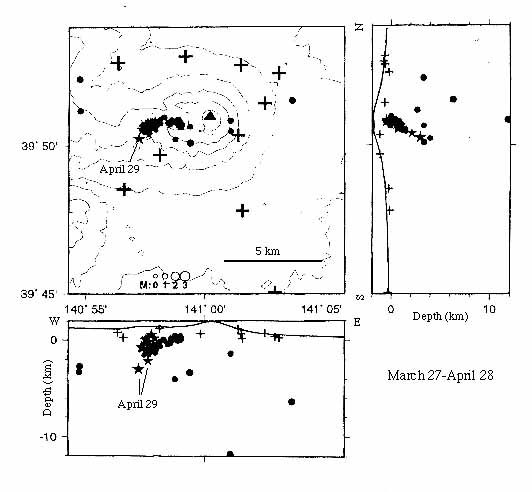
Fig. 1 Volcanic earthquakes in Iwate Volcano (March to April 1998). Crosses are seismic and crustal-deformation observation sites of Tohoku University. Courtesy of Tohoku University.
BACKGROUND OF IWATE VOLCANO
Iwate Volcano is located about 20 km northwest of Morioka City having a population of 283 thousand. It contains basalt and basaltic andesite lavas and pyroclastics, and consists of two volcanic cones; the eastern cone (Higashi-Iwate) is younger than the western cone (Nishi-Iwate). Historic eruptions were limited mainly in the eastern cone. Several eruptions were recorded during these 300 years. In 1732, andesite lava (Yakebashiri-lava) flowed down on the northeastern slope.
Information contacts: NISHIDE Noritake, JMA-Sendai, noritake.nishide@met.kishou.go.jp and nnishide@redc-sn.eqvol.kishou.go.jp; HAMAGUCHI Hiroyuki, Tohoku University, hama@aob.geophys.tohoku.ac.jp; Volcano Research Center, ERI, U of Tokyo, nakada@eri.u-tokyo.ac.jp
LIVE-IMAGE OF IWATE VOLCANO
Visit Iwate University!
To eruption menu