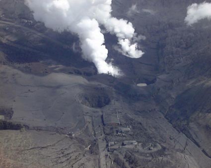
(5/02/00)
Eruption at Usu Volcano has still continued, though in late-April the plume activity become smaller than before. The style of eruption had changed as shown in the below Figure 1. Craters formed in this eruption were counted more than 50 according to Tad Ui, Hokkaido University, who has continued helicopter inspection.
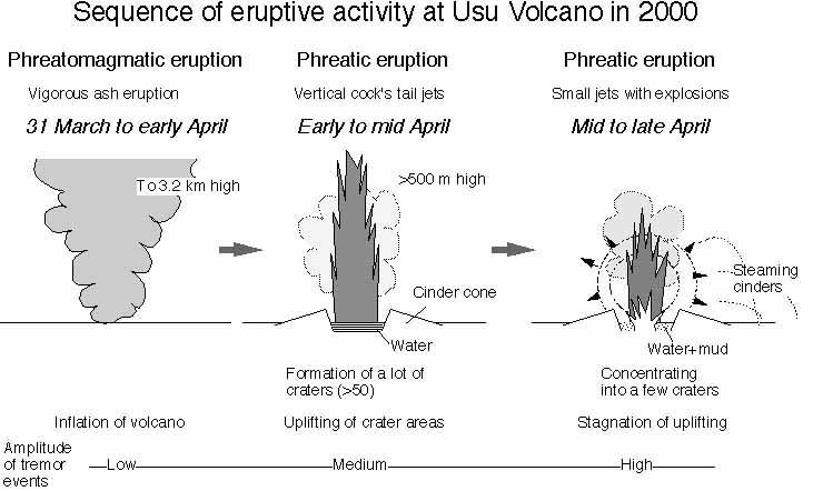
Figure 1. Schematic illustration showing eruption sequence at Usu Volcano during 31 March to end-April. (by VRC_ERI, U-Tokyo).
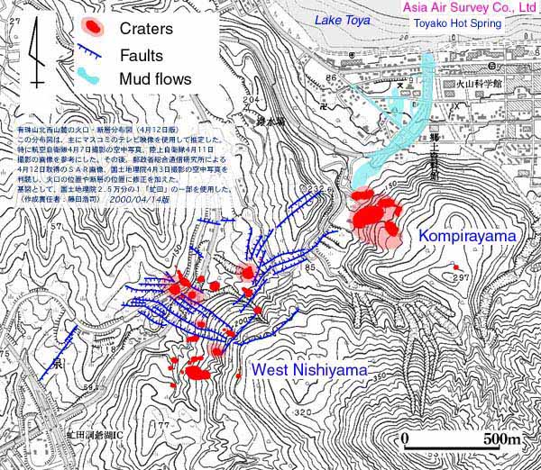
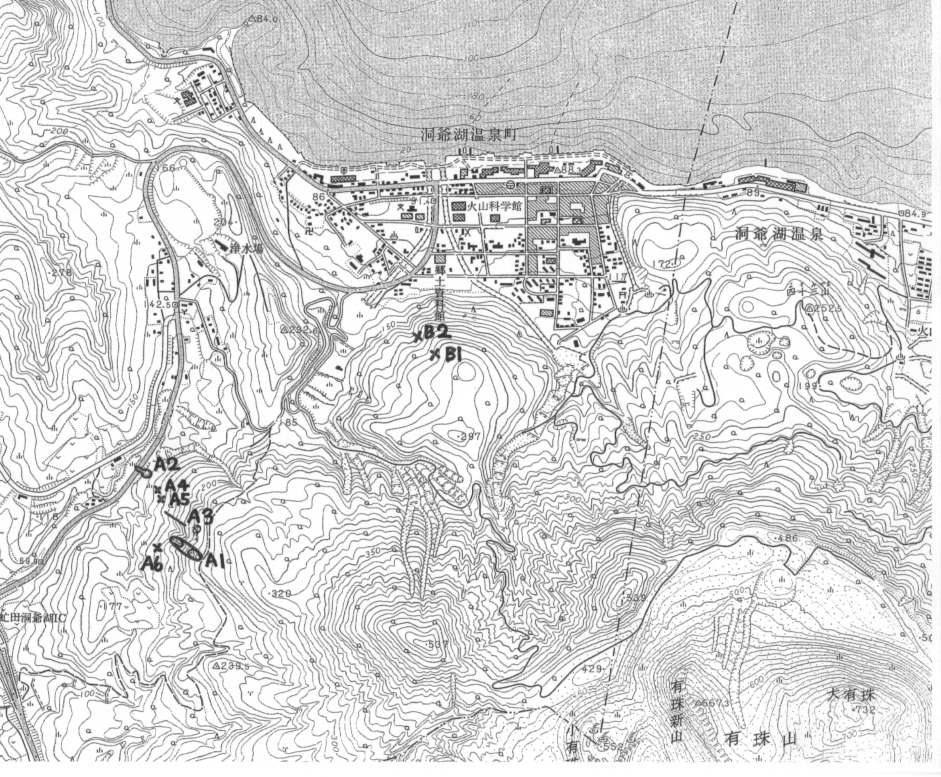
Figure 2. Distribution of craters and faults on 14 April (by Asia Air Survey Co. Ltd.).
Information contact: Asia Air Survey Co. Ltd., Tatsuro Chiba, ta.chiba@ajiko.co.jp; Volcano Research Center, nakada@eri.u-tokyo.ac.jp
Mount Usu's Volcanic Eruptions and Emergency Response of Hokkaido Prefecture,
and
Real time camera of Hokkaido Development Bureau (in Japanese), showing NW view of craters, west Nishiyama.
(4/15/00)
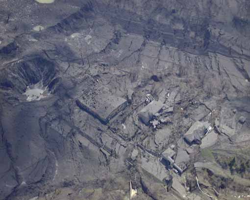
By 10 April, more than 30 craters were formed in two areas, Komipirayama (close to the hot-spring village) and west Nishiyama. The eruption style changed from ash-abundant (phreatic?) eruption to ones (phreatomagmatic) with typical cock's tail jets around 6 April. The jets reached more than 500m above the craters. The latter, water-abundant eruption, changed into small but intermittent explosion with minor cock's tail jets in the west Nishiyama craters since 13 April. Cinders issued by the explosions were steaming after they landed around the craters, implying rocks had been heated by magma. Shock waves were associated with explosions. These temporal changes in eruption style can be understood by a story in which the magma head approached the aquifer, which is estimated to around 0 to 300 m below sea level. by Geological Survey of Hokkaido, and passed almost through it. According to Usu Volcano Observatory, whose observation was strengthened by Joint Research Group (universities, Geological Survey of Japan, Geographical Survey Institute and JMA), the amplitude of volcanic tremors had increased since 6 April and, furthermore, become larger since 12 April. According to Geographical Survey Institute, the region including two crater areas elevated as much as more than 10 m as maximum during 3 days from31 March to 3 April. Typical faults and cracks were found on the ground especially in the west Nishiyama crater area on April 3. The Joint Research Group has kept monitoring seismologically, geodetically, geochemically and geologically. GPS, EDM and theodolite surveys clearly indicate the inflation of the region including two crater areas, which had still been uplifted more than 1 m a day, suggesting the formation of new cryptdome like Showa Shinzan of the 1944 and 1945 eruption.
Eruption at the Kompirayama crater at Usu Volcano (from SW). The front is the west Nishiyama craters and the background is Toyako hotspring town. Taken by S. Nakada from helicopter on 10 April.
Eruption of west Nishiyama area (from S). Many faults were formed by uplifting of the crater area.Taken by S. Nakada on 10 April.
(4/05/00)
A new crater was formed on Kompira-yama near the previously existing two craters in the morning and raised a grayish plume to about 400 meters elevation, according to JMA. On the western slop of Kompira-yama, a mud flow was observed to flown down slowly toward the spa, raising steam (STV NEWS and HBC). The northern side of the newly formed fault system (appeared on 4 April) on the NW flank (NW of Nishi-yama) uplifted about 10 meters, according to Prof. Okada.
Numbers of earthquake events, according to JMA:
Date - - EQ - LFEQ - FELTEQ - TR
2 Apr.- - 48- 3--3-0?
3 Apr. - - 22 - 0 - 2 - 0?
4 Apr. - - 9 -0 - 1 - 0?
EQ: volcanic earthquake, LFEQ: low-frequency earthquake, FELTEQ: felt
low-frequency earthquake, TR: tremor
At the JMA site about 2 km south of the summit.
(4/04/00)
A new fault system was found a few hundred meters north of the one near the craters (NW of Nishi-yama) on the northwestern flank, according to Prof. Okada, and the area between these two fault systems is subsiding to form a graben. The fracture, formed near the NW part of the summit caldera rim on 30 March was observed to widen, the gap now being about four to five meters wide. GPS measurements have not shown any particular ground deformation, since 3 April (GSI). Eruptive activity continued and a new crater(s?) was found between previously existing two groups of craters (N of Nishi-yama and Kompira-yama), raising white plume to 600 meters high at about 17.00 pm (Asahi News Paper).
(4/03/00)
Three faults, extending east-west for a few hundred meters, were observed to develop on the northeastern flank of the volcano, near the explosion crates (NW of Nishi-yama). The maximum throw of the faults was about ten meters, according to the Joint University Research Group. They form a normal fault system with subsiding in the northern side (Dr. Niida of Hokkaido University). Fresh pumice fragments were found floating in the lake (Toya), about 3.7 km ENE from the vent of the first eruption (31 May) on 2 April, which may come from the magma causing this activity (Geological Survey of Japan and Hokkaido University).
(4/02/00)
Activity of eruption at Usu Volcano had continued. According to the Joint University Research Group and Geological Survey of Japan, the NW part of the volcano had still continued slow deformation. During 31 March and 1 April, uplifting of the area (NW caldera-rim to volcano foot) as large as >30 cm a day and migration to NE by 25 cm for 19 hrs. Small crack systems observed in the N foot supported slow but continual migration of the NW part.
Numbers of earthquake events, according to JMA
Date - - EQ - LFEQ - FELTEQ - TR
27 Mar.- - 16 - 0--?-0
28 Mar. - - 599 - 5 - ? - 0
29 Mar. - - 1629 - 164 - ? - 0
30 Mar. - - 2454 - 326 - 537 - 0
31 Mar. - - 788 - 139 - 299 - 0
1 Apr. - - 159 - 24 - 52 - 0
EQ: volcanic earthquake, LFEQ: low-frequency earthquake, TR: tremor
At the JMA site about 2 km south of the summit.
INFORMATION OF CRATER SITES AND THE ACTIVITY
by Takayuki Kaneko (VRC, U. Tokyo) who inspected from helicopter of Asahi Shinbun on 1 April.
Craters were formed in the order of numbers. The squence of A 4 and 5 craters is not clear.
(4/01/00-3)
New craters appeared near the craters of the previous day and also 1.5-km NE of them. The latter locate close to houses in the hot-resort on the coast of Lake Toya. Cocks-tail jets were frequently observed from the active craters. Sometimes eruption clouds rose more than 2 km from the surface. According to Prof. Ui, a few juvenile materials were recognized in the eruption products of the first eruption by petrological work in Hokkaido University.
(4/01/00-2)
The second phase of eruption likely started at the western foot around 02:50 according to JMA's camera observation.
(4/01/00-1)
According to Volcano Advisory Report No. 14 on Usu Volcano on the 1 April early morning, M4.8 earthquake occurred in this volcano at 03:12 (JST), 1 April. This is the largest quake in this eruption event.
JMA was calling an attention to mudflow triggered by rain fall.
Numbers of earthquake events, according to JMA
Date - - EQ - LFEQ - FELTEQ - TR
27 Mar.- - 16 - 0--?-0
28 Mar. - - 599 - 5 - ? - 0
29 Mar. - - 1629 - 164 - ? - 0
30 Mar. - - 2454 - 326 - 537 - 0
31 Mar. - - 788 - 139 - 299 - 0
EQ: volcanic earthquake, LFEQ: low-frequency earthquake, TR: tremor
At the JMA site about 2 km south of the summit.
(3/31/00-2)
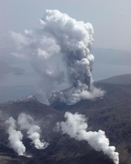
At 13:10 (JST), 31 March, phreatic eruption occurred about 4 km NW of the summit, and about 2 km NE of the epicenter of volcanic earthquakes. The height of volcanic ash became 3,200 m from the crater. Ash and cinders were issued from the newly formed craters. Houses near crater were hit directly by the cinders. After about 2 hours strong emission of volcanic ash, the eruption declined. No injury people were reported. According to Prof. Yoshio Katsui, emeritus professor, who did helicopter inspection reported that five craters formed successively joined into one a large crater (roughly 200 m long and 60 m wide) in this eruption event.
According to the Joint University Research Group this morning, additional cracks were observed in the western flank of the volcano, and on the summit of the old lava dome within the caldera. Cracks found in the northwestern flank and foot of the volcano in the previous day became wider. The activity of seismicity had decreased from the previous day. The temporal change in seismicity unitl the first eruption was very much close to that in the 1910 eruption.
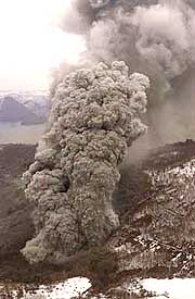
Taken by Asahi Shinbun at 13:45, 31 March
(3/31/00-1)
According to JMA, number of volcanic earthquake was 2,454 on 30 March, including 326 low-frequency earthquakes and 537 of felt ones. Prof. Yoshio Katsui and Hiromu Okada of Hokkaido University found chains of cracks as long as 100 m in the northwestern part of the caldera rim from helicopter, just above the hypocenter of volcanic earthquakes. Geologist group of the same university, Geological Survey of Japan, and Geological Survey of of Hokkaido also found small cracks and signs showing the ground deformation in the north to northwestern foot of the volcano. According to them, the possibility of failure of a part of the northern volcano slope became higher. The hot-spring resort, Toyako-Onsen, on the southern coast of the Toyako Lake, is just included in the area where these phenomena were observed. University research group decided to move the Usu Volcano Observatory of Hokkaido University at the northern foot of the volcano to the western part of the Date City, about 8-km south of the former. The operation at the new building will start on 1 April. Temporal change in the seismic activity (frequency and magnitude) is close to that in the 1910 eruption, which started with phreatic eruption preceded by 5-days precursory phenomena, and was followed by explosions from 45 craters (EW-trending and 2.7 km long), and ended with the formation of cryptdomes.
Numbers of earthquake events, according to JMA
Date - - EQ - LFEQ - FELTEQ - TR
27 Mar.- - 16 - 0--?-0
28 Mar. - - 599 - 5 - ? - 0
29 Mar. - - 1629 - 164 - ? - 0
30 Mar. - - 2454 - 326 - 537 - 0
EQ: volcanic earthquake, LFEQ: low-frequency earthquake, TR: tremor
At the JMA site about 2 km south of the summit.
Hourly numbers of volcanic earthquakes (with Japanese caption, data from JMA) in the site of Geological Survey of Hokkaido.
(3/30/00)
The present state of seismicity at Usu Volcano is the highest in level. Volcanic Alert was issued by JMA on the 29 March morning. This issue is the first time since the Unzen eruption (1990-95). Number of volcanic earthquakes on 29 March was 1,629 (16 and 599 on 27 and 28 March), including low-frequency earthquakes whose number increases with time. Felt quakes that took place on this day over 600 times. The quake of M4.2 occurred at 17:22 (JST), 29 March. According to JMA, the hypocenter of volcanic earthquakes locates on the northwestern slope. The focal mechanism analysis indicates a fault with nearly vertical slip plane. The GPS network of Geographical Survey Institute, Japan, which surrounds the volcano has caught the inflation of the volcano. Neither volcanic tremor event nor visible change in fumarolic gas has been observed yet. Committee including volcanologists, chaired by Prof. Tad Ui, Univ. of Hokkaido, gave the possibilities of an eruption on the northwestern slope, the summit eruption after migration of hypocenter, and phreatic or phreatomagmatic eruption following larger earthquakes. Flank failure and pyroclastic flows are also probable.
People living in a city and two towns around volcano were required to evacuate from their houses by the local governments on the 29 March afternoon. Totally more than 9,000 people and all rourists in the hot spring resorts on the northern foot of this volcano had evacuated by the night.
(3/29/00)
Volcanic Advisory reports (nos. 1-7) on Usu Volcano, Hokkaido, Japan, were issued from Japan Meteorological Agency (JMA) since 28 March. Number of volcanic earthquakes around this volcano has increased since 8 a.m. (JST), 27 March; 16 times in 27 Mar. and 599 in 28 Mar. (including 68 felt-earthquakes) at the JMA site about 2 km south of the summit. At 07:08, 29 March, the quake of M3.4 occurred on this volcano. According to the Usu Volcano Observatory, the hypocenter of the earthquakes locates on the northern slope of the volcano. Neither volcanic tremor nor visible change in fumarolic gas had been observed by the 28 March night.
National Coordination Committee of Volcanic Eruption Prediction (Chaired by Prof. Yoshiaki Ida, Univ. of Tokyo) commented a high possibility of imminent eruption in this volcano in the 28 March evening. JMA is also calling the local people's attention to mud flows triggered due to snow melting by eruption. Hot spring resort locates on the northern foot of the volcano, and about 1,600 guests stayed this night. However, more than 400 persons living around the volcano actively took refuge to safety places like distant schools by the 28 March night, according to the attentions by local governments.
Historical eruptions occurred in 1663, 1769, 1822, 1853, 1910, 1943-45 (Showa-shinzan lava dome eruption), and 1977-78. According to Akihiko Tomiya, Geological Survey of Japan, precorsory phenomena of these eruptions, mainly volcanic earthquake events, before eruptions lasted from 32 hours (1977-78) to 6 months (1943-45 eruption). Most of them began with the Plinian phase, followed by pyroclastic flows and, then, dome growth. The volume of tephra is 0.05 c.km for the 1943-45 eruption to 2.5 c.km for the 1663 eruption. Information on Usu Volcano is in the site, http://uvo.sci.hokudai.ac.jp/
Geologic outline of Usu volcano
Usu volcano (Hokkaido) is one of the most active volcanoes in Japan and was formed on the southern rim of the Toya Caldera around ten thousand years ago. Usu consists of a basaltic main edifice (49-53% SiO2) with a small summit caldera and ten dacitic lava or crypto domes (68-73 % SiO2) on the summit and northern slope. These are aliened in two parallel lines running NW-SE. Several thousand years ago the main edifice collapsed to the south and debris flowed down to the sea. After a long repose period the volcano erupted again in 1663 and since then has undergone six further eruptions. The eruptions that occurred at the summit (1663, 1769, 1822, 1853 and 1977-1978) commenced with a strong Plinian eruption and, apart from 1977-1978 were accompanying by pyroclastic flows. Except the 1769 (?), they also involved the growth of lava or crypto domes in the middle to final eruption stages. In the eruptions that occurred on the slopes (1910 and 1943-1945) the building of lava or crypto domes was proceeded phreatic explosions in the initial stage. Each eruption lasted for one month to two years, with between thirty and hundred years of repose period between them.
Geologic map of Usu volcano-in the site of Geological Survey of Japan
Information contact: Volcano Research Center, ERI, University of Tokyo, nakada@eri.u-tokyo.ac.jp, kaneko@eri.u-tokyo.ac.jp; Geological Survey of Japan, tomiya@gsj.go.jp