Top Next
5-3.Ocean Hemisphere network Project (OHP)
The purpose of this project is to establish geophysical observation networks
centered on the western Pacific for seismology, geo-electromagnetism, and
geodesy, and to look directly into the Earth through the ocean bottoms
where the density of geophysical observations had been sparse. OHP started
as a five-year project in 1996. The Ocean Hemisphere Research Center, which
was inaugurated as one of research centers in the Earthquake Research Institute
in 1997, acts as the center to promote OHP as collaborative nationwide
research activities. Originally, this project was scheduled to end in the
year of FY 2000, but the program committe has approved to extend this project
up to FY2001. We report what progress the project shows for 4 and half
years.
5-3-1. Network Construction
The OHP network consists of seismic, electromagnetic, and geodetic
networks. Up to the present, land stations have been established on schedule
or even with the number exceeding the original plan. Ocean bottom stations
will be completed in the next fiscal year.
5-3-2. Observational system development
The various types of system development required for constructing
the observational networks are important issues. In the following we report
the current status of system development, (a) standard seismic observational
system for oceanic islands, (b) mobile broadband seismic observation system,
(c) standard electromagnetic observation system for oceanic islands, (d)
ocean bottom borehole geophysical observation system, (e) mobile ocean
bottom seismic observation system, (f) ocean bottom electromagnetic observatory,
(g) ocean bottom crustal movement observation system, and (h) ocean bottom
heat flow monitoring system. The system, (d), is explained in the next
section.
The standard seismic observation system for ocean islands was already
completed four years ago, and were improved for solving the Y2K problems
in this year.
We developed the mobile broadband seismic observation system. It has
characteristics of high mobility, easy operation, and low power consumption,
and is suitable for observation in foreign countries. We installed four
systems in China on Oct. 1998 (the details are described in 5-3-7). It
is our first project of the temporally installed seismic observation in
a foreign country. This project is still continued, now.
We developed the standard electromagnetic observation system for oceanic
islands and have been carrying out long-term continuous observations at
seven sites in the Pacific area. System design aimed a high sensitivity
and long-term stability. In order to examine its stability, long-term test
was performed for three years since 1998 by using one of the instruments.
Result indicated that baseline drift in each component does not exceed
5 nT/year, which is better than our expectation.
For the ocean bottom broadband seismic observation by several locations,
a self pop-up type broadband ocean bottom seismometer (BBOBS) has been
developed and deployed in 1999 (Fig. 1, 2 and 3). We have a plan to start
new observations at 2 new locations during 2001.
Instruments for long-term monitoring of temperature profiles and pore-pressure
gradients in seafloor sediments have been developed for purposes of detecting
possible temporal variations of pore fluid flow and heat flow measurements
in shallow sea areas. With the temperature monitoring instrument, we could
obtain one-month record of good quality and are conducting measurements
for a longer period. The pore-pressure instrument has been almost completed
and will be deployed for a long-term monitoring test in 2001.
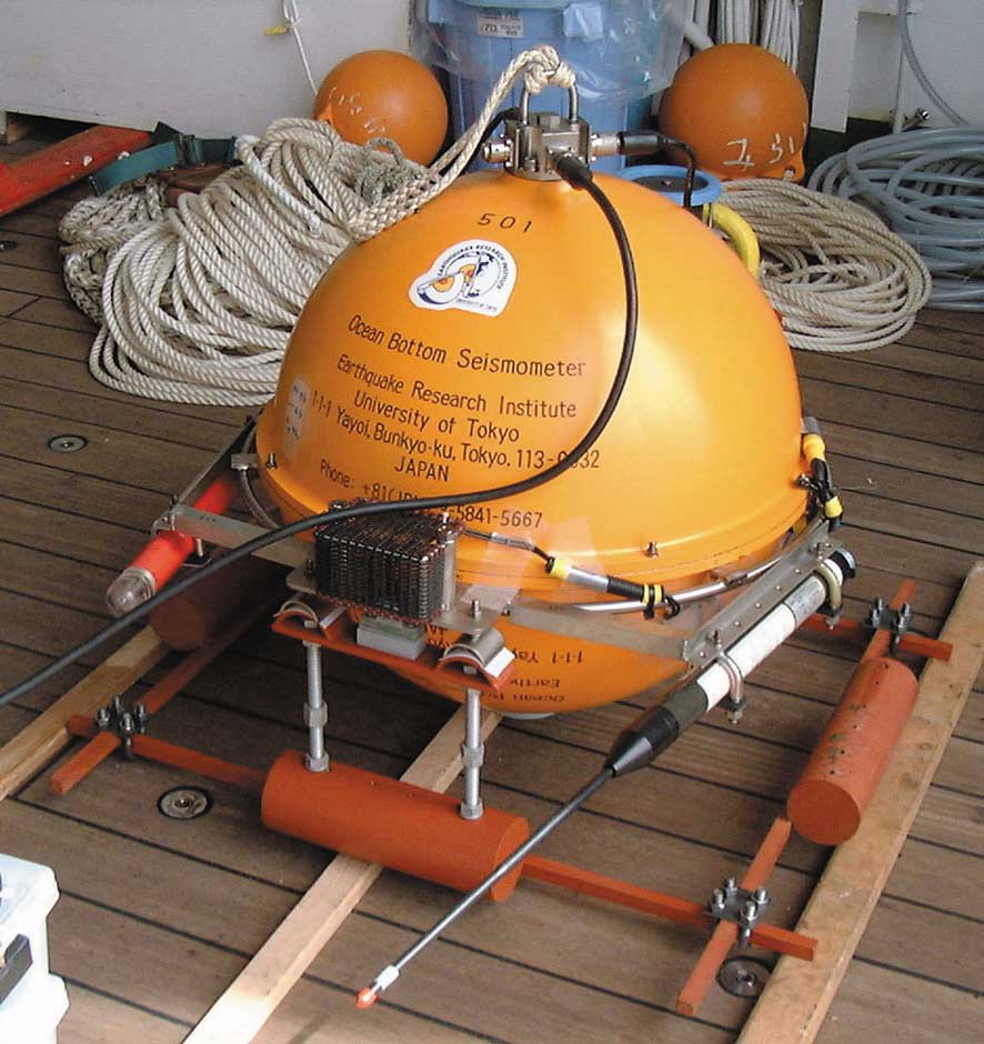
Fig.1. Self pop-up type long-term broadband ocean bottom seismometer
(BBOBS).
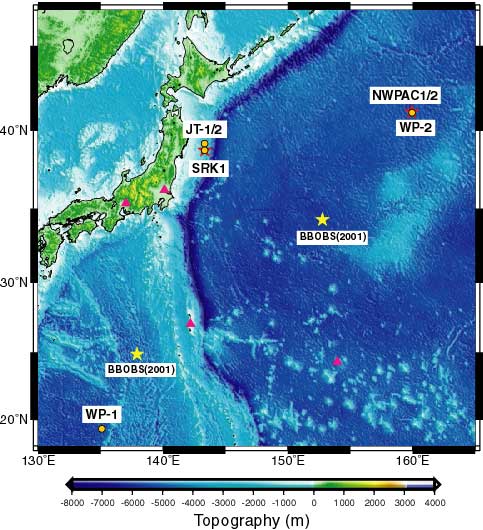
Fig.2. Location map of BBOBSs (stars) and borehole stations (circles).
Triangles indicate land stations.
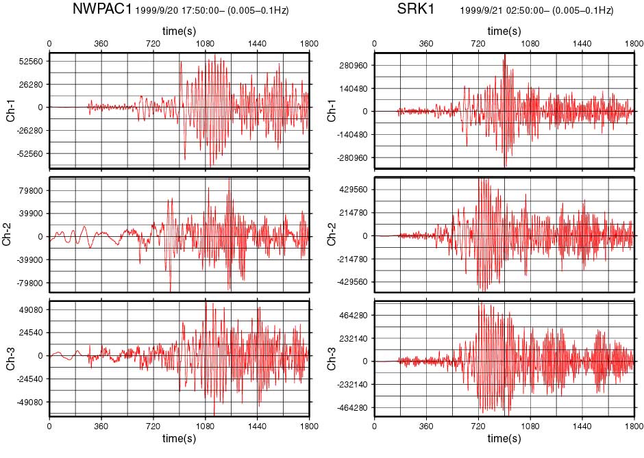
Fig.3. Seismic records of the earthquake occurred in Taiwan (1999/9/20
17:47:19, Ms7.6), obtained by two BBOBSs.
5-3-3. Ocean bottom geophysical observation
It is becoming clearer that emplacement of seismometers inside a borehole
can provide low noise environments in the ocean. In addition, the strainmeter
and tiltmeter, because of their principles of operation, need to be grouted
inside boreholes ideally to behave completely the same as the surrounding
rocks. Ocean Hemisphere Project (OHP) planned to install four ocean floor
borehole geophysical observatories in three areas of the western Pacific.
The main objective of installation of borehole stations is to obtain high
quality data for a high-resolution image beneath the western Pacific. Two
borehole geophysical observatories (JT-1 and JT-2) on the landward slope
of the Japan Trench were successfully installed in July and August 1999
during ODP Leg 186. In August 2000, the installation of a seismic observatory
(WP-2) in the northwestern Pacific Basin was completed by ODP Leg 191.
The observatories were activated by a ROV.
Fig. 4 shows the arrangement of the sensor and the seafloor packages
for JT-1. Sensors were placed near the bottom of the hole and were grouted
by cement. The signals from the sensors are sent to the sea floor packages
by the cables. The seafloor packages consist of the recorder and the Sea
Water Batteries. For JT-1 and JT-2, the sensors consist of a strainmeter,
a tiltmeter, and two broadband seismometers. Two same seismometers are
used at WP-2. The maintenance of the observatories is performed by a ROV.
Because the seafloor packages are connected using the Under Water Mateable
Connectors, each unit can be recovered by a ROV for the maintenance. From
the preliminary data of JT-1 and WP-2, we found that boreholes at the sea
floor provide quiet environments for seismic observation (Fig. 5). For
completion of the network construction, installation of a seismic station
in the western Philippine Basin is scheduled in April, 2001 during ODP
Leg 195.
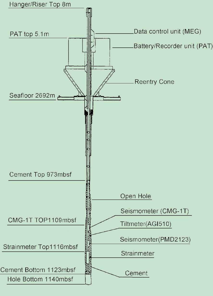
Fig.4. Schematic of equipments used in the borehole installation
at JT-1. Other stations have fundamentally the same configuration.
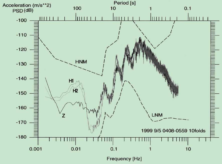
Fig.5. Seismic noise spectra from the borehole seismometers at JT-1.
Z and H1,H2 denote the noise spectra estimated from the vertical component
and the horizontal components respectively. HNM and LHN indicate typical
noise spectra from the land observatories. The noise spectra at JT-1 show
that JT-1 can provide good quality data.
5-3-4. GPS observations in the western Pacific
Regional permanent GPS array has been established in the western Pacific
and eastern Asia since around 1995 and was named as WING (Western Pacific
Integrated Network of GPS). The newly established sites are more than ten
until the end of 2000. Together with otherwise establushed sites, more
than 40 GPS sites have been routinely analysed.
Fig. 6 shows a summary of thus estimated GPS velocity field in the
area. The figure includes results from repeated survey conducted mainly
by ERI group. Established GPS array has been able to delineate overall
displacement rate field in the area as well as used as reference sites
for local arrays of repeated surveys. Fig. 6 indicates rigid motions of
Pacific and Philippine Sea plates that moves toward west. In addition,
back-arc spreading and other plate boundary deformations along the converging
plate boundaries in the western Pacific are readily visible. On the other
hand, Chinese continent shows areal deformations due to collision of Indian
continent toward north.
In order to further investigate tectonics and dynamics of the crust
and the upper mantle in the area, the network is still planned to augment
in the future. This network shall be used not only for solid earth physics
but also used for meteorology, climatology, hydrology and ionospheric researches.
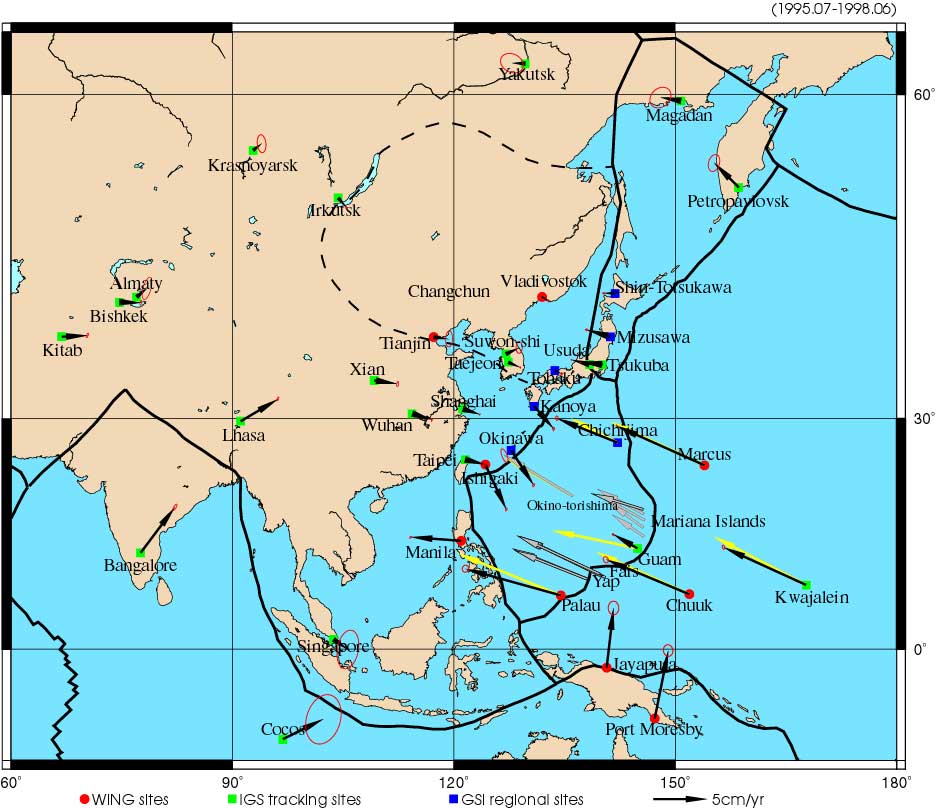
Fig.6. Western Pacific Integrated Network of GPS (WING) and velocity
vectors referred to stable Eurasia. Black arrows: velocities at permanent
sites, White arrows: velocities by repeated surveys, Yellow arrows: estimated
velocities from plate motion models. Sites of short history and those without
sufficient data are not included.
5-3-5. Data Center
Ocean Hemisphere Project Data Management Center (OHPDMC) constructed
the data distribution system for interdisciplinary OHP network data and
began to open them to the public. OHPDMC also contributed to the further
promotion of seismic waveform data circulation via the following activities:
a) Construction of Network Data Center
Various broadband seismograph networks are being operated by Japanese
institutes, but their data are distributed from various data centers in
various data format with various user interfaces. To solve this inconvenience
we developed networked data distribution system providing various networks
data with a unified user interface in international standard data format
(Fig. 7). We also set up the system so as to be able to integrate not only
OHP network data but also various international and domestic networks data.
We made CD-ROM (Fig. 8) of this integration software and distributed it
to researchers in the world.
b) Data Report to Federation of Digital Broadband Seismograph Networks
(FDSN)
We converted Japanese broadband seismic networks data to the international
standard format, and reported them to the international union for data
exchange (FDSN) as a representative of Japan.
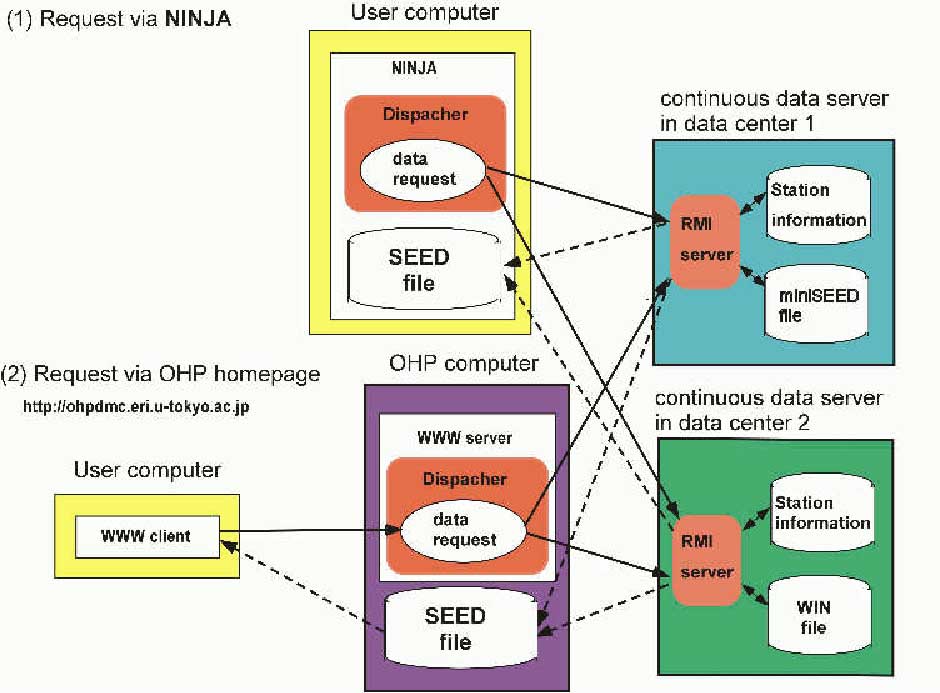
Fig.7. Networked data distribution system developed by OHP data management
center.

Fig.8. CD-ROM of the software integrating data via the networked
data distribution system.
5-3-6. Data analysis
The first objective of OHP is to complete the Ocean Hemisphere networks.
Besides, the major science target is to extract new information related
to the Earth's interior by analyses of data from being constructed and
existing networks. Outcome of such researches includes: (a) development
of a new efficient data analysis method, (b) study of electrical conductivity
structure of the mantle beneath NE China, (c) elucidation of plate motions
in the western pacific region, (d) detailed study of the mantle transition
zone in the western Pacific region, (e) discovery of the Earth's background
free oscillations (cf. 5-5), (f) improvement of the resolution of seismic
tomography.
For example, in (b), observation of long-baseline telluric field variations
is carried out by using telephone lines in northeastern China (Fig. 9).
Data obtained from this experiment were analyzed to study electrical conductivity
structure of the mantle beneath this area. Two different methods were applied
and both indicated a similar model with a sudden conductivity increase
at the depth of 600-800 km (Fig. 9). In (d), by analyzing data from the
high density broadband seismic networks in Japan, first in situ seismological
estimation of the density jump across the transition zone discontinuities,
which is known to be very difficult, is performed beneath Japanese islands,
and density jumps significantly smaller than the reference earth models
are obtained (Fig. 10). In (f), PP wave travel time data are newly obtained
from broadband waveforms to improve existing P wave tomography model, especially
in the upper mantle. The new model, for example, shows a slow velocity
region beneath Hawaii, which appears localized in the upper mantle (Fig.
11).
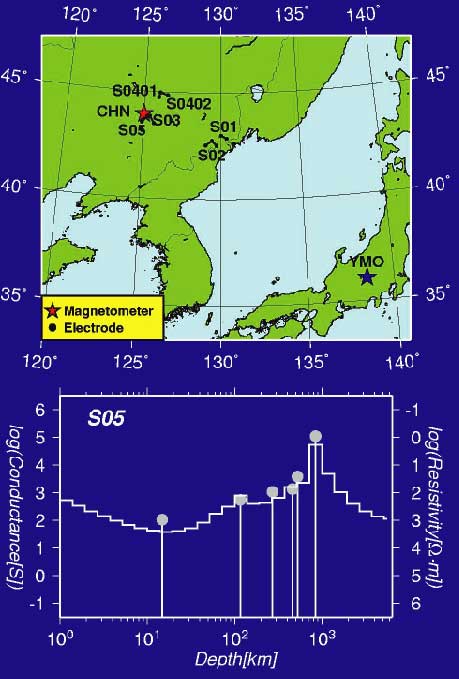
Fig.9. (Top) Electric observation sites in NE China. (Bottom) The
inferred 1-D electrical conductivity models beneath S05. Two different
models are shown; one with smoothness constraints and the other expressed
by delta functions of conductance.
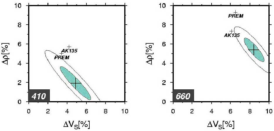
Fig.10. Density and S-wave velocity jumps at the mantle transition
zone discontinuities.
Tomography beneath Hawaii

Fig.11. Seismic velocity structure beneath Hawaii. (top) old model
with direct P wave data only. (middle) new model with P+PP wave data. (bottom)
cross sections above are along the red line in this map.
5-3-7. Seismic and electromagnetic array observation
along the Philippine Sea-China profile
As a part of the Ocean Hemisphere network Project, we performed long
term seismic and electromagnetic (EM) array observation along the Philippine
Sea-China profile (Fig. 12) to reveal more detailed image of inhomogeneous
mantle structure of so-called the zone of down-going mantle flow.
Ocean bottom seismic observation was carried out for eight months
from Nov. 1999 until July 2000 by using 15 semi-broad band ocean bottom
seismometers (LTOBS) along a profile of about 2800 km length. The LTOBS
contains a semi broad-band sensor (WB2023LP, PMD) in a pressure case made
of titanium sphere (D=50cm), which enables us long-term observations up
to one year. The data quality was preliminarily examined using PDE catalog.
Events with Mb 5.5 or larger within epicentral distances of 70 degrees
are well recorded with adequately high S/N. We found that several deep
events in Japan, Izu-Mariana and Fiji and some events in Alaska are well
recorded.
Along the same profile and during the same period, ocean bottom EM
observation was also carried by using 6 ocean bottom electro-magnetometers
(OBEM). Each OBEM measures variations of three components of the geomagnetic
field and two components of the electric field every minute. All the instruments
were safely recovered, and good records were obtained.
On-land broad-band seismic observation was started at four stations
in China by a collaboration with the Analysis and Prediction Center, China
Seismological Bureau. The observation was originally planned to have 16
sites, which had to be reduced due to several difficulties. However, this
will not cause serious problem because data from the network in China (CDSN)
became available.
In Jilin Province of northeast China, we have performed observation
of electric field variations by using telephone lines (Network-MT) by collaborating
with Institute of Geology, China Seismological Bureau. The observation
area is known to its recent active volcanism, and its relation to deep
structure is one of the most interesting targets. This project will be
continued for the coming several years to extend the study area.
Our new data set from seismic and EM observations will provide unique
opportunity to investigate the upper mantle structure in the western Pacific
region in more details.
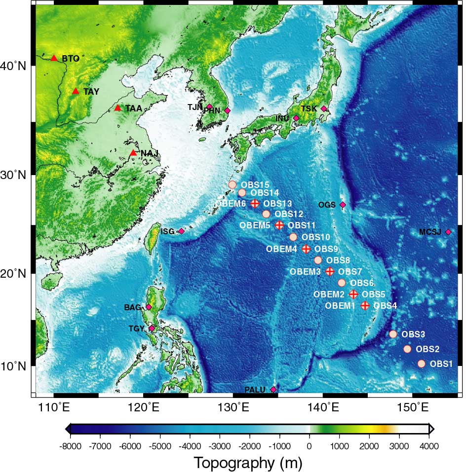
Fig.12. Locations of ocean bottom sites in the Philippine Sea and
on-land seismic sites
Top Next