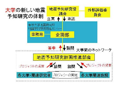
Fig.1. New organization of Universities for an earth-quake prediction research.
The Earthquake Prediction Research Center (EPRC) was established in 1994 as a core facility to promote national or international research projects on earthquake prediction. To establish a scientific method for predicting a large earthquake, we still need basic researches for which university scientists bear responsibility. A major role of EPRC is to coordinate individual large-scale research projects on earthquake prediction so that they are carried out effectively. In 2000, the coordinating committee of the Earthquake Prediction Research Committee was established at EPRC.
(http://www.eri.u-tokyo.ac.jp/YOTIKYO/index.htm)
Fig.1. New organization of Universities for an earth-quake prediction
research.
●Cooperative Researches
1. Laboratory Experiment on Earthquake Generation Process
For physical modeling of a large earthquake for predictive purposes, it is critical to understand in terms of the underlying physics how and under what conditions a large-scale earthquake rupture is nucleated in a seismogenic environment at the final stage where enough elastic strain energy has been stored, what factors determine the size of the nucleation zone and its timescale for major earthquakes, and whether or not there are any precursory phenomena necessarily associated with the nucleation process. One of the current research projects focuses on establishing the constitutive law that governs earthquake generation processes, and thereby modeling the earthquake generation process in a lithospheric environment. To this end, a unique, state-of-the-art testing apparatus with a high-pressure and temperature spherical cell was constructed (Fig.3) to investigate constitutive properties of shear failure of rock in the brittle to brittle-plastic transition regimes under lithospheric conditions.
2. Deformation Process of Island Arc Crust
The EPRC and EOC have been a responsible organization for multi-disciplinary project of "Deformation process of island arc crust". This project is aiming at elucidating various scale structural inhomogeneity from well-organized seismic expeditions using active and passive seismic sources. The 1997-1998 expeditions provided a new image of crustal structure across Northern Honshu Arc. Particularly, in the western part of Honshu, crust has been highly deformed by the Miocene back-arc spreading. In 1999-2000, an extensive seismic expedition was undertaken in central Hokkaido to investigate the deformation process associated with arc-arc collision. Refraction and reflection surveys succeeded in imaging obducting Kuril Forearc to a depth range of 10-15 km.
3. Active Fault Researches
EPRC has conducted active fault researches since 1997. Since destructive inland earthquakes tend to occur near the base of the seismogenic layer, revealing the entire fault structure from a shallow depth to the depth of the base of seismogenic layer is crucial to elucidate a possible mechanism of destructive earthquake generation, and thereby to infer damage from a destructive earthquake. Hence, the entire structures of active faults have been studied using very shallow to crustal-scale seismic reflection profiling. The deep to shallow seismic reflection profiling, conducted in 1997 and 1998 across the Ou Backbone Range in northern Honshu, revealed the geometry and the connectivity of an entire active fault system. In 1999-200 seismic reflection profiling was carried out across the Hokkaido axial zone and its western fold and thrust belt. Seismic profiles revealed an entire geometry of active thrust system in seismogenic layer, including shallow blind thrust at the front. Joint research projects on shallow seismic reflection profiling were undertaken with several universities. EPRC has also performed researches on the surface earthquake faults associated with destructive earthquakes, such as 1999 Chi-Chi earthquake in Taiwan and 2000 Tottori-ken-seibu earthquake in SW Japan.
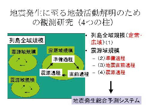
Fig.2. Study and observation of the processes in the earth's crust leading to earthquakes.
For physical modeling of a large earthquake for predictive purposes, it is critical to understand in terms of the underlying physics how and under what conditions a large-scale earthquake rupture is nucleated in a seismogenic environment at the final stage where enough elastic strain energy has been stored, what factors determine the size of the nucleation zone and its timescale for major earthquakes, and whether or not there are any precursory phenomena necessarily associated with the nucleation process. One of the current research projects focuses on establishing the constitutive law that governs earthquake generation processes, and thereby modeling the earthquake generation process in a lithospheric environment. To this end, a unique, state-of-the-art testing apparatus with a high-pressure and temperature spherical cell was constructed (Fig.3) to investigate constitutive properties of shear failure of rock in the brittle to brittle-plastic transition regimes under lithospheric conditions.
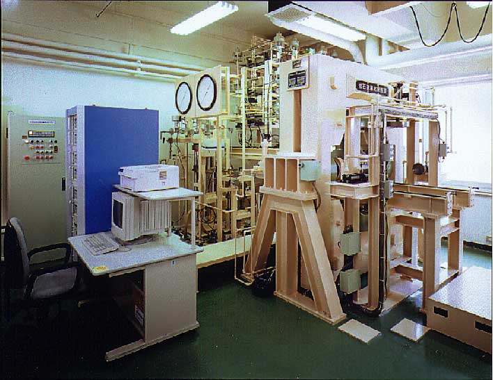
Fig.3. Testing apparatus constructed to reveal constitutive properties of shear failure of rock in the brittle to brittle-plastic transition regimes under lithospheric conditions.
2. Deformation Process of Island Arc Crust
The EPRC and EOC have been a responsible organization for multi-disciplinary
project of "Deformation process of island arc crust". This project is aiming
at elucidating various scale structural inhomogeneity from well-organized
seismic expeditions using active and passive seismic sources. The 1997-1998
expeditions provided a new image of crustal structure across Northern Honshu
Arc. Particularly, in the western part of Honshu, crust has been highly
deformed by the Miocene back-arc spreading. In 1999-2000, an extensive
seismic expedition was undertaken in central Hokkaido to investigate the
deformation process associated with arc-arc collision. Refraction and reflection
surveys succeeded in imaging obducting Kuril Forearc to a depth range of
10-15 km.
3. Active Fault Researches
EPRC has conducted active fault researches since 1997. Since destructive inland earthquakes tend to occur near the base of the seismogenic layer, revealing the entire fault structure from a shallow depth to the depth of the base of seismogenic layer is crucial to elucidate a possible mechanism of destructive earthquake generation, and thereby to infer damage from a destructive earthquake. Hence, the entire structures of active faults have been studied using very shallow to crustal-scale seismic reflection profiling. The deep to shallow seismic reflection profiling, conducted in 1997 and 1998 across the Ou Backbone Range in northern Honshu, revealed the geometry and the connectivity of an entire active fault system. In 1999-200 seismic reflection profiling was carried out across the Hokkaido axial zone and its western fold and thrust belt. Seismic profiles revealed an entire geometry of active thrust system in seismogenic layer, including shallow blind thrust at the front. Joint research projects on shallow seismic reflection profiling were undertaken with several universities. EPRC has also performed researches on the surface earthquake faults associated with destructive earthquakes, such as 1999 Chi-Chi earthquake in Taiwan and 2000 Tottori-ken-seibu earthquake in SW Japan.
4. Study on Electric Resistivity Structure
EPRC plays an important role in cooperative projects to study the electric resistivity structure in and around Japan. The NETWORK-MT experiment, which was developed in the Earthquake Research Institute, aims to study the relation between mean resistivity structure and features of crustal activity in Japan. A detailed survey is also carried out in a tectonically active area. Basic studies are also being undertaken to develop instruments for surveys, methods of field observations, and methods of analysis and modeling. The generating mechanisms of earthquakes, volcanic eruptions, and slow crustal deformations have been studied through various electromagnetic observations. In particular, our major targets of observations are intermittent swarm earthquakes and anomalous crustal uplift in the eastern part of the Izu Peninsula and some active volcanoes in the Izu-Bonin Arc. EPRC has also conducted observations of geomagnetic total intensity with proton precession magnetometers (Fig.4), ground resistivity using natural and controlled sources, and self electric potential (SP) with long-distance telephone cables.
For the period 1999 - 2000, we carried out the following work: 1) Network MT observations in the north-central Hokkaido, western Chugoku and western Shikoku districts, 2) To have clarified the resistivity structure of a most typical active fault, Sen-ya fault and its western vicinity, 3) Investigation of the anomalous geomagnetic total intensity changes in a rather local area in eastern Izu Peninsula, 4) Resistivity soundings in two active earthquake swarm region by TDEM method, i.e. the eastern Izu and Iitaka-Town, Mie Prefecture, 5) To have observed remarkable changes in the total intensity and self potential prior to and associated with the 2000 eruption of Miyake-jima volcano, which contributed to realize the eruption processes.
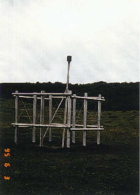
Fig.4. Proton precession magnetometer (Miyake-jima Volcano).
5. GPS Researches on Crustal Deformation Process
The Global Positioning System (GPS), a space geodetic technique
to measure crustal deformation accurately, has been widely deployed in
Japan, and GPS is a powerful tool to monitor crustal deformations of a
variety of scales (Fig.5). EPRC serves as the headquarters of the Japanese
University Consortium for GPS Research (JUNCO), not only to promote various
cooperative GPS projects in Japan, but also to establish an international
GPS network in the western Pacific area to monitor plate motions (see 6-5
Application of GPS). The deformation process of the Japanese islands has
been studied based on dense GPS arrays; for instance, post-seismic recovery
of the 1995 Kobe earthquake was monitored with a dense GPS array by JUNCO,
and a GPS array was deployed in the Ito area under the supervision of JUNCO.
A new type of tsunami-meter using GPS has been developed. EPRC has joined
a new project called "GPS meteorology", which started in 1997 as a project
run by the Science and Technology Agency.
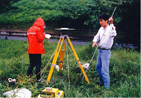
Fig.5. Global positioning system.