4-3. Study on the structure
and dynamic of the Earth’s deep interior by Ocean Hemishpere Network
This
project is a continuation of the Ocean Hemisphere Network Project (OHP) that
has been carried out from 1996 - 2001 FY. The OHP established a new network of
geophysical observatories, including seismology, geoelectromagnetism, and
geodesy, in the western part of the Pacific region where the density of
geophysical observations had been particularly sparse. The OHP network enabled
us to look directly intot he interior of the Earth through the ocean bottom.
The research has very long perspective as a whole. The first phase has
been completed and the second phase has just started where new development of
the OHP research is made by performing mobile array observations that
interpolate long-term network observations and by inverting multidisciplinary
long-term geophysical data. For the moment, ERI and IFREE will be cooperatively
carry out the research project of the post OHP phase including maintenance of
the network and data management. There is a ERI cooperative research program so
that all concerning research institutions in Japan are involved in this
project. As a better solution for a long-term continuation of the OHP project,
it is planned that all concerning institutions built a consortium to maintain
the OHP network. The Ocean Hemisphere Research Center (See Section 6) has been
and will be acting as the center to promote the OHP research as nationwide
collaborative scientific activity.
Major scientific results so
far obtained are summarized below.
4-3-1. Network Construction
The OHP
network consists of seismic, electromagnetic, and geodetic networks. Up to the present, not only land
stations but also ocean bottom ones have been established on schedule. The
stations map and list of the network is shown in the part of "OHP
center" in page xx. The stations in
the OHP network are managed cooperatively by universities and research institutions
in foreign countries based on the cooperative research project. We stand now on
the next step to promote international cooperative research in the field of the
international field geophysics using the relationship to these university and
research institutions.
4-3-2. Observational system development
The various types of system development required for constructing the
observational networks are important issues. In the following we report the
current status of system development, (a) standard seismic observational system
for oceanic islands, (b) mobile broadband seismic observation system, (c)
standard electromagnetic observation system for oceanic islands, (d) ocean
bottom borehole geophysical observation system, (e) mobile ocean bottom seismic
observation system, and (f) ocean bottom heat flow monitoring system. The system (d) is explained in the next
section.
The standard seismic observation system for ocean islands has already
been completed, and is in use at 11 stations in 7 countries.
The mobile broadband seismic observation system was also developed for
temporally installed observations that complement the permanent OHP
network. It has characteristics of
high mobility, easy operation, and low power consumption, and is suitable for
observation in foreign countries.
We installed four systems in China on Oct. 1998 and six ones in Vietnam
(the details are described in 4-3-7).
We developed the standard electromagnetic observation system for oceanic
islands and have been carrying out long-term continuous observations at nine
sites in the Pacific area. System
design aimed a high sensitivity and long-term stability. In order to examine its stability, long-term
test was performed for three years since 1998 by using one of the instruments.
Result indicated that baseline drift in each component does not exceed 5
nT/year, which is better than our expectation.
For the broadband seismic
observation in the huge oceanic area, the self pop-up type broadband ocean
bottom seismometer (BBOBS) has been developed and deployed since 1999 (Figs. 1,
2 and 3). Based on the proved
BBOBS's performance, new ocean-land observations in the French Polynesia have
been started in 2003 in cooperation with IFREE/JAMSTEC.
Instruments for long-term monitoring
of temperature profiles and pore-pressure gradients in seafloor sediments have
been developed for purposes of heat flow measurements in shallow sea areas and
detecting possible temporal variations of pore fluid flow. We have already
obtained up to ten-month records with the temperature monitoring instrument
and succeeded in determination of
the heat flow by removing effects of the bottom water temperature variation. The
pore-pressure instrument has been almost completed and long-term monitoring
tests on the seafloor are being
conducted.
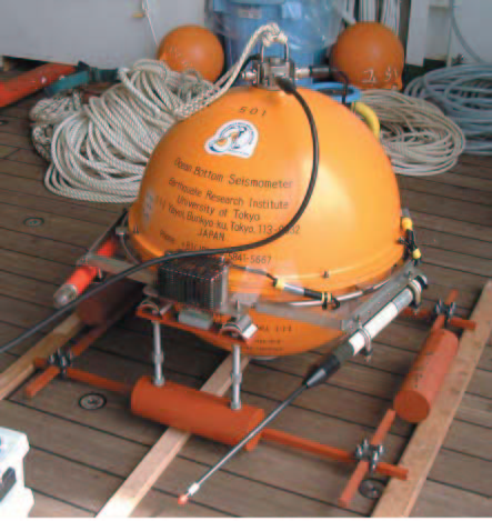
Fig.1. Self pop-up type long-term broadband ocean bottom
seismometer (BBOBS).
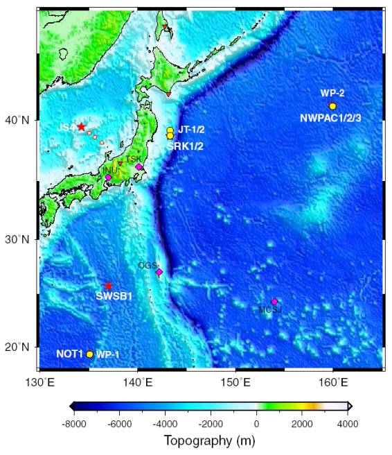
Fig.2. Location map of BBOBSs (stars) and borehole stations (circles). Triangles indicate land stations.
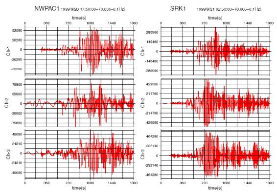
Fig.3. Seismic
records of the earthquake occurred in Taiwan (1999/9/2017:47:19, Ms7.6),
obtained by two BBOBSs.
4-3-3. Long-term
monitoring using sea floor borehole
It is becoming clearer that emplacement of
seismometers inside a borehole can provide low noise environments in the ocean.
In addition, the strainmeter and tiltmeter, because of their principles of
operation, need to be grouted inside boreholes ideally to behave completely the
same as the surrounding
rocks. Ocean Hemisphere Project (OHP) planned to install four ocean floor
borehole geophysical
observatories in three areas of the western Pacific. The main objective of
installation of borehole stations is to obtain high quality data for a
high-resolution image beneath the western Pacific. Two borehole geophysical
observatories (JT-1 and JT-2) on the landward slope of the Japan Trench were
successfully installed in July and August 1999 during ODP Leg 186. In August
2000, The installation of a seismic observatory (WP-2) in the northwestern
Pacific Basin was completed by ODP Leg 191. The last seismic observatory (WP-1)
was constructed in the west Philippine basin by ODP Leg 195 in April 2001. The
observatories were activated by a Remotely Operated Vehicle (ROV).
Figure 4 shows the arrangement of the
sensor and the seafloor packages for WP-1. Sensors were placed near the bottom
of the hole and were grouted by cement.
The signals from the sensors are sent to the sea floor packages by the
cables. The seafloor packages consist of the recorder and large capacity
lithium batteries. For JT-1 and JT-2, the sensors consist of a strainmeter, a
tiltmeter, and two broadband seismometers. Two identical seismometers are used
at WP-1 and WP-2. The maintenance of the observatories is performed by an ROV
in cooperation with Earthquake Observation Center, ERI and Deep Sea Research
Department, JAMSTEC. Because the seafloor packages are connected using the
Under Water Mateable Connectors, each unit can be recovered by a ROV for the
maintenance (Fig5).
Until February 2003, about a
half-year continuous data and more than one-year data are obtained from WP-1
and WP-2, respectively. JT-1 and JT-2 started the observation from 2002. At present,
all four stations continue observation. From the long-term data from WP-1 and
WP-2, we found that boreholes at the sea floor provide quiet environments for
seismic observation and there is no temporal variation of seismological noise
level. The simultaneous observation of WP-1 and WP-2 started from March 2002
(Fig. 6).
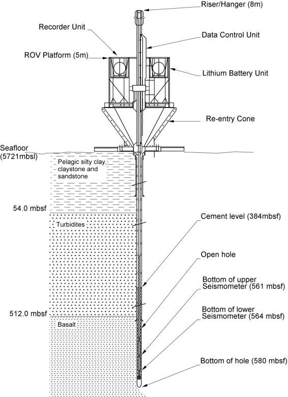
Fig.4. Schematic of equipments used in the borehole
installation at WP-1. Other stations have fundamentally the same configuration.
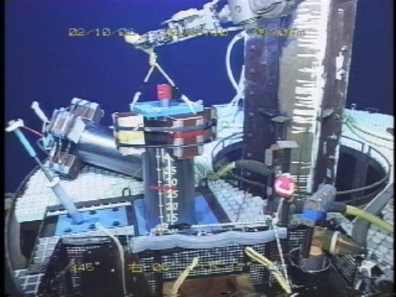
Fig.5. The exchange of the data recorder at the WP-1
station (Oct. 6th, 2002). The new recorder was being set to the proper position
by the ROV KAIKO belonging to JAMSTEC.
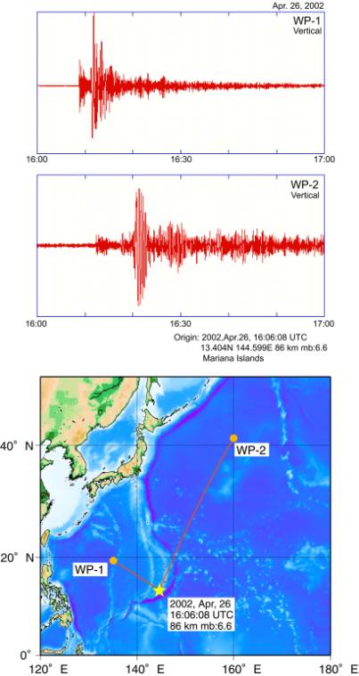
Fig.6. Earthquake recorded by both WP-1 (Upper) and
WP-2 (Middle). One-hour records of vertical component from April 26th, 2002,
16:00:00 are shown. No filtering is applied. The earthquake occurred in the Mariana Islands region (April
26th, 2002, 16:06:08 UTC, depth 86km, mb6.6). Orange lines indicate ray path
for each station (Lower).
4-3-4. GPS observations in the western Pacific
Regional
permanent GPS array has been established in the western Pacific and eastern
Asia since around 1995 and was named as WING (Western Pacific Integrated
Network of GPS). The newly
established sites are more than ten until the end of 2000. Together with otherwise establushed
sites, more than 40 GPS sites have been routinely analysed.
Fig. 7 shows
a summary of thus estimated GPS velocity field in the area. The figure includes results from
repeated survey conducted mainly by ERI group. Established GPS array has been able to delineate overall
displacement rate field in the area as well as used as reference sites for
local arrays of repeated surveys. Fig. 7 indicates rigid motions of Pacific and
Philippine Sea plates that moves toward west. In addition, back-arc spreading
and other plate boundary deformations along the converging plate boundaries in
the western Pacific are readily visible.
On the other hand, Chinese continent shows areal deformations due to
collision of Indian continent toward north.
In order to
further investigate tectonics and dynamics of the crust and the upper mantle in
the area, the network is still planned to augment in the future. This network shall be used not only for
solid earth physics but also used for meteorology, climatology, hydrology and
ionospheric researches.
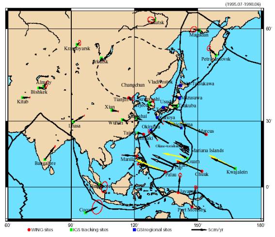
Fig. 7. Western Pacific Integrated Network of GPS (WING) and velocity
vectors referred to stable Eurasia. Black arrows: velocities at permanent
sites, White arrows: velocities by repeated surveys, Yellow arrows: estimated
velocities from plate motion models. Sites of short history and those without
sufficient data are not included.
4-3-5. OHP Data Center
OHP
data center is continuously editing and distributing the data from OHP
network. As for broadband seismic
data, we are providing a unified interface for data centers in Japan, Taiwan
and U.S.A. via NINJA system which were developed in OHP project. We are now operating OHP data center in
a close colaboration with IFREE in JAMSTEC and will continue this in the
future.
Besides
that, we began to exam intruduction of on-line system for OHP network. Because of rapid and worldwide popularization
of the Internet, the time has come to exam on-line system even for oversea
stations. We are now examing the introduction of Antelope sytem developed by
Boulder Real Time Technologies, Inc. and are now evaluating it (Figure 8).
We are also examing the replacement of data loggers to Q330 developed
by Quanterra which has a mechanism for real-time data transmission, and are now
evaluating its performance compared to data loggers developed by other
companies.
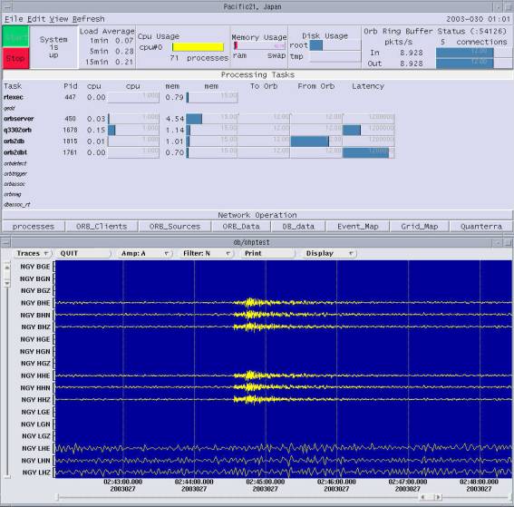
Figure 8: GUI interface of
Antelope.
4-3-6. Recent progress in
data analysis
<Trans-Pacific
Temperature Field in the Mantle Transition Region from Seismic and
Geoelectromagnetic Tomography>
Seismic wave speed and electrical conductivities are two physical
properties that can be estimated from geophysical observations on the Earth’s
surface yet their sensitivities to the Earth’s interior environments such as temperature
are mutually very different. Comparative studies of the three-dimentional
distributions of seismic velocity anomalies and electrical conductivity anomalies
are therefore promising to elucidate the thermal filed in the mantle. Towards
this goal we (in collaboration with the IFREE/JAMSTEC) examined the consistency
between the temperature fields converted from the seismic tomography map by
Fukao et al. (2003) and from the electrical conductivity tomography map by
Koyama (2001). For the seismic conversion we used the semi-theoretical formula
of Karato (1993) and for the electrical conversion we used an experimental
result of Xu et al. (1998). Figure 9 shows the P-wave velocity anomaly
distribution at a depth of 500 km, where two dominant features are the low
velocity anomalies beneath Hawaii and high velocity anomalies under the western
Pacific. Figure 10 shows the cross-sections for temperature anomaly at depths
300-1000 km along the J and P profiles illustrated in Figure 1, which traverse
Hawaii –Japan and Hawaii-Philippine, respectively. Despite gross differences in
the data and conversion formulae used the estimated temperature fields show
consistency: 200-400 K above the normal beneath Hawaii and 200-400 below the
normal under the western Pacific.
<Broadband Waveform Inversion for Whole Mantle S Wave Structure
Model>
Ocean
Hemisphere Project (OHP) is a project to extensively deploy the observational
station at the ocean region where the station density was coarse. We developed a new analysis
method to accurately invert for the structure beneath oceans, and applied it to
OHP and pre-existing seismic network data.
Our analysis method has
following two appealing points:
(1) retrieving all of the information of seismic waveform data by using
waveform data itself as dataset instead of retrieving a part of information
extracted from waveform data such as P wave arrival time,
(2) improving the distorted image beneath oceans (whose resolution kernel
is prolonged in a particular direction because of event-station distribution)
by appropriately data.
Applying this method, we
inverted for whole mantle S wave velocity structure. Figure 11 shows the obtained upper mantle model.
We also show the model obtained without using our weighting method. The model obtained by using our data
weighting method shows good agreement between distribution of mid-ocean ridges
and distribution of low velocity anomaly.
In the near future, we will constrain dynamics beneath oceans by
analysing huge data via huge computation using Earth Simulator.
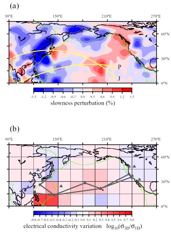
Figure 9. P-wave velocity
anomaly distribution at depths 480-550 km (Fukao et al., 2003). High and low
velocity anomalies are colored blue and red, respectively. Tomographic
cross-sections will be taken along two profiles J and P.

Figure 10. (a)Cross-section of temperature anomalies at depths 300-1000
km along profile J across Hawaii and Japan from the seismic tomography.
(b)Cross-section of temperature anomalies at depths 350-850 km along profile J
from the geoelectromagnetic tomography. (c)Cross-section of temperature
anomalies along profile P across Hawaii and Japan from the seismic tomography.
(d)Cross-section of conductivity anomalies along profile P from the
geoelectromagnetic tomography. See Figure 1 for the locations of the two
profiles and for other explanations.
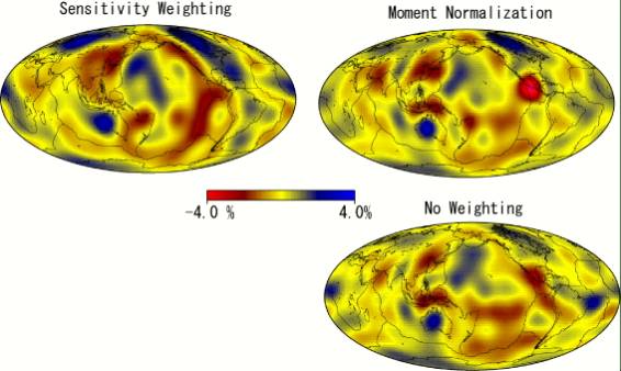
Figure 11: Upper mantle (Moho-310 km) S wave velocity structure model obtained
by using our data weighting methd (sensitivity weighting) and not using our
data weighting method (moment normalization and no weighting).
4-3-7. Temporal and mobile observation to
complement the OHP network
To reveal
detailed structure deep inside of the Earth and to focus on regional structure
in foreign countries, and seismic and geomagnetic array observations are
carried out temporally. The largest project was carried out along the
Philippine Sea - China profile described below. And several
smaller scale projects are planed and are also implemented
independently.
As a part of
the Ocean Hemisphere network Project, we performed long term seismic and
electromagnetic (EM) array observation along thePhilippine Sea-China profile
(Fig. 12) to reveal more detailed image of inhomogeneous mantle structure of
so-called the zone of down-going mantle flow. This project is composed of Ocean
bottom seismometer array, ocean bottom geomagnetic one and on-land seismometer
one. Ocean bottom seismic observation was carried out for eight months from Nov.
1999 until July 2000 by using 15 semi-broad band ocean bottom seismometers
(LTOBS) along a profile of about 2800 km length. The LTOBS contains a semi
broad-band sensor (WB2023LP, PMD) in a pressure case made of titanium sphere
(D=50cm), which enables us long-term observations up to one year. The data
quality was preliminarily examined using PDE catalog. Events with Mb 5.5 or larger within epicentral distances of
70 degrees are well recorded with adequately high S/N. Analyses with the data of the surface
wave and the receiver function is on the way under cooperation of IFREE. Along the same profile and during the
same period, ocean bottom EM observation was also carried by using 6 ocean
bottom electro-magnetometers(OBEM). Each OBEM measures variations of three
components of the geomagnetic field and two components of the electric field
every minute. All the instruments
were safely recovered, and good records were obtained. On-land broad-band
seismic observation was continued at four stations in China by a collaboration
with the Analysis and Prediction Center, China Seismological Bureau. Using the data
acquired by these arrays, we will provide unique opportunity to investigate the
upper mantle structure in the western Pacific region in more details.
In addition, we have made long-term
(several months to one year) ocean bottom Electromagnetic array observations in
the western Pacific region around Japan to study the deep electrical
conductivity distribution, by using ocean bottom electro-magnetometers (OBEM).
Recent experiments were done in the Mariana region with the LTOBS (2001-2002)
and in the Japan Sea (2002-2003). Each OBEM measures variations of three
components of the geomagnetic field and two components of the electric field
every minute.
In
Jilin and Liaoning Province of northeast China, we have performed observation
of electric field variations by using telephone lines (Network-MT),
collaborating with Institute of Geology, China Seismological Bureau. The
observation area is known to have recent active volcanism, whose relation to
deep structure is one of the most interesting targets. This project will be continued for the
coming several years to extend the study area.
In
March 2002, we started a new project on seismic array observation in Vietnam,
collaborating with Institute of Geophysics in Vietnam (Fig.13). The array network is national wide in
Vietnam and it is composed of 6 broadband seismometers. For Japanese side, the
target of the project is revealing the deepest part of the Earth (Inner Core
boundary, Core Mantle Boundary), using the antipodal waveform that makes weak
phases enhanced by focusing effect. Vietnam is located at the antipodal area of
deep seismic zone in South America, and one of rear places where the antipodal
waveforms can be observed frequently. We will analyze the antipodal waveform to
shed light on the structure at deepest part of the Earth. Vietnamese
researchers to study on the seismotectonics along Yunnan Province in China and gulf
of Tongkin (i.e. Red river faults zone) using broadband seismograms acquired in
this project. We would like to continue the cooperative research for scientific
purpose and to make it fruitful for mutual parties.
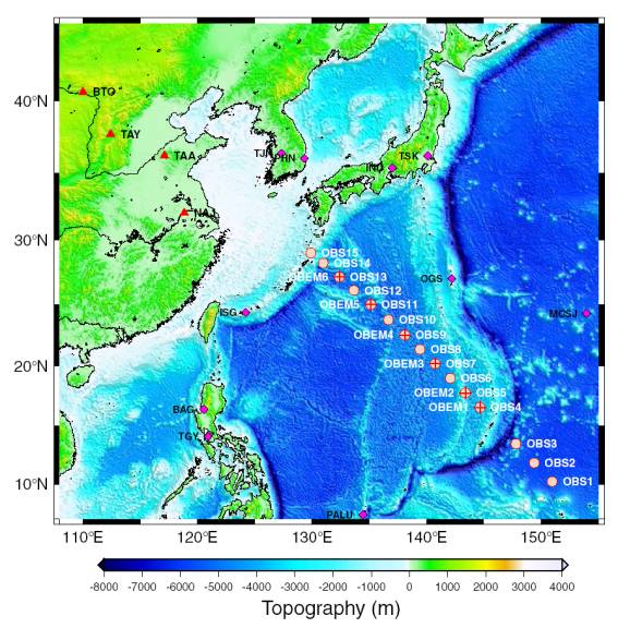
Fig.12. Locations of ocean bottom sites in the Philippine Sea and on-land
seismic sites in China.
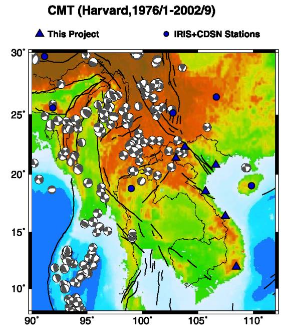
Fig.13. Locations of broadband seismic stations in Vietnam conducted by
this project (triangles) and broadband stations of other networks in
surrounding countries (circles).