6-3)Division of Monitoring and Computational Geoscience
Development of Brand-new
Geo-monitoring Instruments
(1) Laser
Interferometers
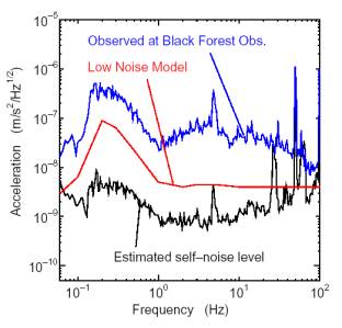
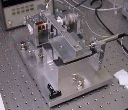
A new instrument with high performance or high reliability often opens up new fields of geophysics. With this belief, we developed new instruments. Shown in Fig.1 is an interferometric wideband seismometer. Output signal of the seismometer can be calibrated with reference to the laser wavelength of its own. Laser-diode interferometry with high sensitivity serves to excellent performance of the seismometer which can sense even the minimum background seismic noise (Low Noise Model), as shown in Fig.2. We are also trying to develop other instruments such as high-precision borehole instruments, represented by an optically-linked tiltmeter, and an absolute gravimeter in small size.
Fig.1 Interferometric wideband seismometer.
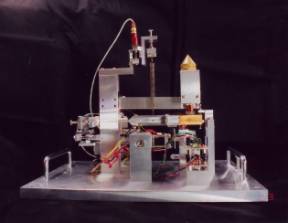
Fig.2 Estimated self-noise level of the
seismometer.
(2) ACROSS (Accurately
Controlled Rotary Seismic Source) Tomography
We are developing a tomography based on accurately harmonic elastic wave. This system is composed of a phased array of artificial seismic sources and an array of seismographs. The source is an oscillator in which an eccentric mass is driven by a servomotor and is installed under the ground. We maintain the frequency of the sources constant. We also deploy sensors in a dense array. Recorded data are stacked immediately and the SN ratio of the data is augmented.
The mathematical feature of the ACROSS tomography is an inversion of the harmonic wave field. This is a young subject and a lot have to be exploited. But we can transform it mathematically to a conventional velocity tomography. Another approach is a phased array operation of many sources in which resolution is expected to be significantly improved. In this approach, the scattering structure is identified directly.
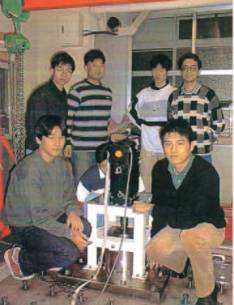
The source undoubtedly is the center of concern. High-speed rotation of an eccentric mass with accurately constant velocity for a long time is an unexplored technology and many inventions have been needed. We made the first model in 1998 and have been examining it in the laboratory (Fig.3). We also completed improved and stronger sources, installed them in a deep tunnel of Kazunogawa Power Station, eastern part of Yamanashi prefecture, of Tokyo Electric Power Company and currently conducting experiments.
Fig.3. Accurately controlled Source with 1
ton force.
(3) Development of
broad-band/highly sensitive seismometers with a magnetic levitation technique
Development of new instruments with new ideas is important to open up a new window of the earth science. To be more specific, one of the essential points in designing broad-band/highly sensitive seismometers lies in how to cancel gravitational force applied to a pendulum to achieve a long natural period. We have developed vertical and horizontal pendulums in which magnetic levitation counter-balances the gravity. We believe that the astatic seismometers described below would greatly surpass the performance of previous ones.
The first seismometer uses an astatic rotational-vertical pendulum (Fig.4a); a gravitational torque at the weight is canceled by a magnetic torque with a permanent plunger magnet. It has a weak leaf-spring crossed hinge as a rotational axis. The magnetic torque is generated by a parallel and uniform magnetic field. The natural period of this pendulum is longer than 8 seconds. The broad-band/highly sensitive seismometer using the rotational pendulum and a velocity feedback circuit has sensitivity of several tens microgals at 1 Hz. The second seismometer uses a horizontal pendulum (Fig.4b) having a weak leaf-spring crossed hinge and using magnetic levitation for a pendulum weight. The levitation employs a permanent magnet magnetized by N, S strip, alternatively. This magnetization makes a flat energy potential just above the magnet surface and brings stable levitation. This pendulum with the magnetic levitation achieved a natural period longer than 11 seconds.
Fig.4 (a)
Astatic rotational-vertical pendulum.
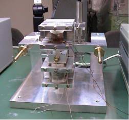
Fig.4 (b) Leaf
spring horizontal pendulum with magnetic levitation.
Theoretical and
Observational Studies on Temporal and Spatial Variations of the Gravity Field
Minute gravity chages occur when crustal deformation and/or transport of underground materials occurs: ascent of magma, co-seismic uplift/subsidence, pre-seismic groundwater migration. We try retrieving information on the subsurface deformation from observed surface gravity.
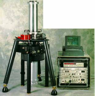
(1) Gravity field monitoring at tectonically active regions. We repeat gravity measurements several times a year at the Tokai subduction area, Asama Volcano, Izu Peninsula and other locations. The combination of an absolute gravity measurement (FG5 gravimeter in Fig.5) and a relative one (LaCoste & Romberg gravimeter) enables us to determine spatio-temporal gravity changes with an accuracy and a precision of 1-5 microgals. We apply the elastic/viscoelastic dislocation theory to the observed gravity change to estimate the underground deformation process. We have visited the Usu volcano, Miyake-jima Volcano, Izu-Oshima Volcano, Sakurajima Volcano, Mt. Fuji area, and the Tokai area since 2000.
Fig.5. The FG5
high-precision absolute gravimeter.
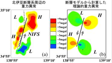
(2) Physical interpretation of gravity anomaly around active faults. A peculiar gravity anomaly pattern often occurs around active faults. We postulate the hypothesis that the current gravity anomaly manifests as a result of an accumulation of repeated co-seismic gravity changes in the past. In particular, the gravity anomaly around the Northern Izu Fault System is explained well by geomorphologically determined offset and seismic fault parameters of the 1930 Kita-Izu earthquake (Fig.6).
Fig.6. Gravity anomaly around the Northern
Izu Fault System. (left) Gravity anomaly expected from the
accumulation hypothesis.
(right) Observed gravity anomaly after removing the regional trend.
Crustal
deformation measurement by interferometric synthetic aperture
radar(InSAR)
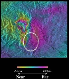
The total number of permanent GPS receivers to monitor the crustal deformation in Japan exceeds 1000 at present. However, the spatial separation of each receiver is 20-30km on the average, which is not sufficient so that we can observe them in the close vicinity of hypocenters and active volcano. Interferometric synthetic aperture radar(InSAR) plays a complementary role, measuring cm-order ground displacement over 100km**2 region with fine spatial resolution. Fig.7 shows coseismic ground displacements due to the Onikobe earthquake(M5.9) in Aug. 1996, based upon JERS1 data. It should be noted that conventional techniques of crustal deformation measurement were difficult to set up in mountainous area like Onikobe.
Fig.7. Coseismic ground displacement due to the
Aug. 1996 Onikobe earthquake(M5.9). Distance changes in the line of sight
toward the satellite are detected. Changes in the Near(Far) shows the an
uplift or eastward displacement(subsidence or westward displacement) of the
ground. Dashed line indicates the rim of the Onikobe caldera.
Theoretical Study of
Earthquake Ruptures
(1) Mechanical effects of fluid flow on
earthquake faulting
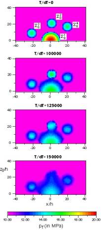
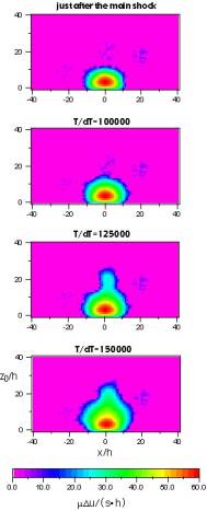
Field investigations have indicated the existence of strong correlation between fluid flow in a fault zone and earthquake occurrence there. We have successfully shown in our numerical simulations that regularity and complexity of seismic activity are explained in a unified way by assuming fluid flow in a fault zone.? For example, if the rate of pore creation is large enough, rupture sequences with features of earthquake swarms can be simulated. This occurs because of the temporal increase of fracture strength near the fault front due to fluid flow into newly generated pores from the surroundings. If the occurrence of main shock causes a large increase in permeability and a large decrease in cohesive strength, rupture sequences with features of aftershocks can be simulated. Fig.8 shows an example of aftershock sequence; spatio-temporal variations of fluid pressure and fault slip on a fault are specifically illustrated. We successfully simulated such regularity of aftershocks as the Omori law and the Gutenberg-Richter relation as well as the complexity like the occurrence of secondary aftershocks. It is also shown that the emergence of the Gutenberg-Richter relation is closely related to the occurrence of repeated slip on a fault zone.
Fig.8. (a) Spatio-temporal variation of fluid
pressure in the fault zone, (b) Spatio-temporal variation of fault slip.
(2) Geometrical
complexity of fault system and its generation process
The geomtry of earthquake fault is, in general, very complex, and we observe the bending or bifurcation at the tips of earthquake fault. However, it is not understood well how such complexity is formed during the dynamic growth process of earthquake fault. Our recent study has shown that the formation of fault system depends significantly on the initial arrangement of fault segments and fault tip velocity.
Simulation of Seismic
Source Processes and Applications to Design of Structures
(1) Computer Simulation
of Rupture Process and Generation of Strong Motion
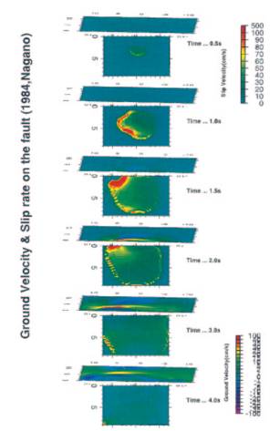
An inversion of seismic waveforms has been used to infer distributions of kinematic parameters, e.g., slips or moment release or rupture time on the fault. It is based on kinematic fault models that include some arbitrary assumptions. We have proposed an efficient method to reconstruct physically a reasonable dynamic rupture process with the constraint of kinematic inversion results and applied it to several earthquakes. The heterogeneous distributions of stress drop and fault strength excess have been revealed. In the method, ground motions near the fault are also calculated. Fig.9 shows snapshots of slip velocity on the fault and ground motions generated for the 1984 Naganoken-seibu earthquake.
Fig.9.
The slip velocity on the fault and the ground velocity at each time
step for the 1984 Naganoken-seibu earthquake.
(2) New Design
Methodology of Structures against Strong Near Earthquakes
The concept of L2 design seismic load, which was introduced into the design of civil engineering structures, has not been thoroughly investigated, and serious confusion exists among engineers. Our basic idea to establish a rational design method is 1.) to develop a highly reliable structural analysis based on the integration of earthquake sciences and structural mechanics, and 2.) to control vibration and damage. Following this strategy, we are designing new large structures located in the neighborhoods of active faults and are accumulating and analyzing detailed data.