6-4) Division of Disaster Mitigation
Science
Earthquake Engineering
The objective of earthquake engineering is to
prevent or mitigate disasters, especially damage to structures, cause by
earthquakes. Academic or practical
methods of simulating or evaluating 1) design earthquake motion, 2) response,
3) seismic performance, 4) damage, or 5) risk, are developed and improved
through observation, experiment (Fig. 1 and Fig. 2 ), analysis, and theory, for
application to seismic design, repair and strengthening of structures and
ground.
Fig.1. Shaking table test of 6-story one-third
scale reinforced concrete wall-frame building structure with soft first
story, July 2000. (a) 6-story piloties frame specimen before test. (b) Response of overall and first story drift
angles to the maximum input motion of equivalent Takatori 135 kine.
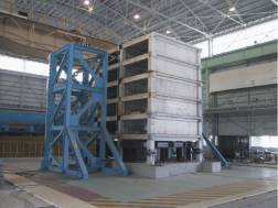
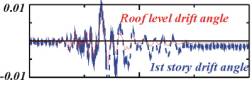
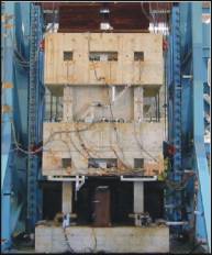

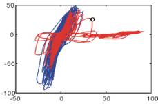
Fig.2. Shaking table test on 2-story eccentric
piloties frames for analysis of axial load collapse mechanism and
performance verification of SRF strengthening method of reinforced concrete
columns, November 2001. (a) 2-story eccentric piloties frame specimens
before test. (b) Comparison of damages to RC column and SRF column under
the same motion. (c) Comparison of hysteretic behavior of RC column and SRF
column.
Damageability of strong ground motions
In
order to mitigate earthquake disaster, we have to investigate damageability of
strong ground motions in addition to investigation of strong ground motions and
structures. Damageability of strong ground motions, i.e., structural damage, is
determined by the relationship between intensity of strong ground motions and
strength of structures, therefore, we have to grasp characteristics of both
strong ground motions and structures. The result of the investigation leads to
index of representing damageability of strong ground motions, such as J.M.A.
(Japan Meteorological Agency) seismic intensity. Such index is essential to
grasp actual structural damage rapidly and accurately for quick post-disaster
response. Slow post-disaster response enlarged human damage in the 1995
Hyogoken-Nanbu Earthquake. However, many strong ground motions records are need
to be obtained under the same structural condition for such investigation.
In
the 1999 Chi-Chi earthquake, Taiwan, many strong ground motions records were
obtained under the same structural condition. This made it possible to
investigate index of representing damageability of strong ground motions from
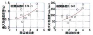
actual structural damage for the first time. The relationship between often
used index and proposed index (elastic response with a 5% damping factor around
1.0 sec) and actual damage (area damage level) is shown in Figs. 3 and 4,
respectively. Almost no correlation was found for PGA and a weak correlation for
PGV, SI and JMA intensity whereas, there is good correlation for proposed index
with area damage level.
Fig.3. Relation between index of representing
damageability and area damage level
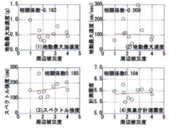
Fig.4. Relation between elastic response (5%
damping for period 1s (left) and 0.8s (right) and area damage level.
Strong Motion Seismology
A
quantitative prediction of strong ground motion is the most fundamental and
inevitable subject for preventing and reducing earthquake damage. Along this
subject, we have studied following items.
1) Study on source spectral
characteristics based on strong motion observations near a fault: We focus to
identify generations of high frequency motions on a fault and to increase an
accuracy of strong motion predictions.
2) Strong ground motion
simulations mainly using the empirical Green's function method: Examples are
estimations of source parameters and strong ground motions of the 1855
Ansei-Edo earthquake and assessments of strong ground motion near the surface
fault during the 1999 Turkey earthquake.
3) Effects of sites on
strong motion and their relation to structural damage: We have faced that no or
light damage near a fault and heavy damage to buildings, on the contrary, were
found at relatively long distance (>100km) from the source. This is mainly
due to properties of surface sediments at sites and we are practically studying
based on the data from the 1999 Turkey earthquake.
4) Determination of S-wave
velocity structure for assessing site characteristics: The spatial
auto-correlation method applied to array data of microtremors. The method has
been confirmed by the comparisons of S-wave velocity structure with those by
the other methods. The method is especially superior in determining velocity
model at deep sediment sites with low cost. Figure 5 compares the structure
models by a reflection survey, a sonic log using deep borehole, and
microtremors. Figure 6 shows a comparison of the observed bedrock motion at depth
1300 m with the synthesized one by deconvolving surface motion using the model
determined by microtremors.
5) Strong motion database:
Strong motion data are most invaluable for confirming a seismic safety of
buildings and man-made structures. We have started to construct a user-friendly
database.
Fig.5. Structure model
determined by microtremors (right) compared with the results by reflection
survey (left) and sonic log.
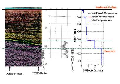
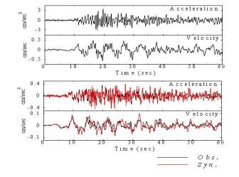
Fig.6. The bedrock motion (red) at depth of 1300 m
synthesized by deconvolving the surface motion using the model determined
by microtremors is compared with the observed ones (black).
Applied Seismology
Seismologists
are responsible for mitigating earthquake disasters, so precisely estimating
seismic ground motions is one of our most important tasks. We are working on any problems related
to this task, and our recent research subjects are as follows:
1) Modeling earthquake faults and
their rupture processes as sources of seismic ground motions (e.g. Rupture
process of the 1995 Kobe earthquake, Fig. 7).
2) Exploring detailed images of
underground structures, which should influence seismic ground motions (e.g.
three-dimensional ray tracing in a subduction zone and tomographic analysis of
explosion data).
3) Numerical simulation of seismic
ground motion caused by fault rupture in a three dimensional heterogeneous
structure (e.g. simulation of strong ground motion caused by the 1995 Kobe
earthquake, Fig. 8).
Fig.7. Fault model
(lower) and its slip distribution (upper) for the 1995 Kobe earthquake
(after Yoshida, Koketsu et al. 1996).
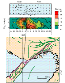
Fig.8. Numerical
simulation of seismic ground motion caused by the 1995 Kobe
earthquake. The upper and
lower diagrams represent the distribution of peak ground velocities and
their temporal snapshots.
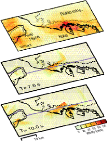
Strong Motion Simulation
The
dense networks of strong ground motion instruments in Japan (K-NET and KiK-net)
make it possible to directly visualize regional wave propagation during large
earthquakes. For the 2000 Tottori-ken Seibu earthquake (Mw 6.6) in western
Japan, snapshots of ground motion, derived directly from interpolation of a
large number of array observations, demonstrate clearly the nature of the
source radiation pattern and the character of the seismic wavefield propagating
to regional distances (Fig.9-right). During the earthquake of shallow thrust
faulting, the favefield is dominated in longer-period (T =10 s) fundamental-mode Love waves on displacement
records.
The
observation is then comparing with results from a 3-D numerical simulation. A
realistic model of the source process for the earthquake and 3-D subsurface
structural model of western Japan are included in the simulation model. The
computation is conducted by using a cluster of 8 PCs. There is good agreement
in the dominant features of the regional wavefield propagating through the
complex structure (Fig.9). For example, the amplification effects in the highly
populated sedimentary basins can be observed. The simulation model is,
therefore, suitable for estimating the main pattern of ground motion expected
for future earthquake scenarios.
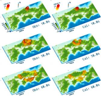
Fig.9. Strong ground motion during the Tottori-ken
Seibu earthquake in 2000. Observed ground motion from dense array (left), (b)
Simulation result (right) at time T=10, 30, 60s.
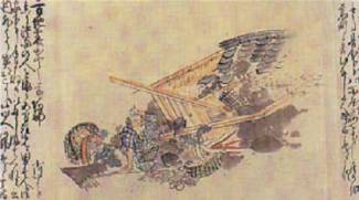
Geological Tracing of Historical Tsunamis
We
can trace historical and pre-historical tsunamis by sampling vertical piston
cores of lagoon bottom deposit sediment layers. We made a piston core sampling
in a lake called "O-Ike" at Sukariura village, Owase City, on the SE
coast of the Kii peninsula (Fig.10).
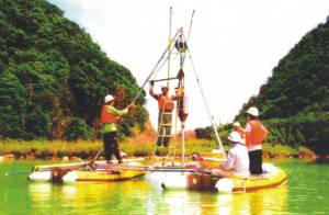
Fig.10. Working raft for core sampling in
lagoons.
We
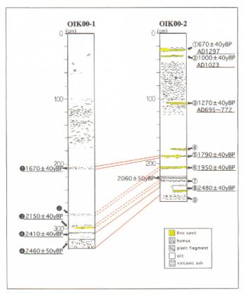
detected 9 thin sand layers, which had been formed by major Tokai earthquakes
(Fig.11). The result of C-14
dating shows that, the date of the oldest tsunami is 6 century BC. This study is promoted as a co-working with Prof. M. Okamura, Kochi
University.
Fig.11. Examples of core
samples of O-ike lagoon, Owase city, Kii peninsula. Yellow marked thin sand layers are formed by
historical and pre-historical tsunamis accompanied by the major Tokai
earthquakes.
Historical Seismology
We
started the historical study on earthquakes in 1975. The documents collected, which contain descriptions of
earthquakes and tsunamis, were published as a series of books,
"Shinto-Nihon Jishin Shiryo (New collection of materials for the study of
historical earthquakes in Japan)", which consists of 21 volumes, amounting
to 16, 812 pages altogether. The
materials collected are used in the long-range prediction of earthquakes and
the mitigation of disasters caused by large earthquakes and tsunamis (Fig. 12).
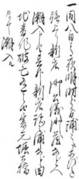
Fig.12. The tsunami records in
"Tanabe-cho Daicho" (The official diary of the mayor of Tanabe
City).