6-5) Earthquake
Prediction Research Center
The Earthquake Prediction Research Center (EPRC) was
established in 1994 as a core facility to promote national or international
research projects on earthquake prediction. To establish a scientific method
for predicting a large earthquake, we still need basic researches for which
university scientists bear responsibility. A major role of EPRC is to coordinate
individual large-scale research projects on earthquake prediction so that they
are carried out effectively. In 2000, the coordinating committee of the
Earthquake Prediction Research Committee was established at EPRC.
●Earthquake Prediction Research Committee and
Coordinating Committee
In 1998, the Japanese Geodesy Council submitted a
recommendation titled as “Promotion for the new Program of the Study and
Observation for Earthquake Prediction” to the Ministry of Education, Culture,
Sports, and other related ministries. This is the 5-year national program since
1999. Following the recommendation, Japanese universities established a new
structure toward the earthquake forecast study (Fig.1). In September 1999, the
Earthquake Prediction Research Committee was established in the Earthquake
Research Institute of the University of Tokyo, which is a shared institute of
Japanese universities. The EPRC promotes the earthquake prediction researches
in Japanese universities to plan, conduct, and evaluate the research programs
(Fig.2). The EPRC includes a coordinating committee and seven standing panels
(Program Promotion Panels) for promotion of individual programs. The
coordinating committee has both full-time and part-time researchers proposes
basic research plans. The committee allows representatives from academic
institutes outside ERI to coordinate earthquake forecast research efforts among
them. The ERRC also has an external evaluation committee to evaluate the
scientific merit of the university programs.
(http://www.eri.u-tokyo.ac.jp/YOTIKYO/index.htm)
Fig. 1 New organization
of Universities for an earth-quake prediction research.
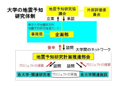
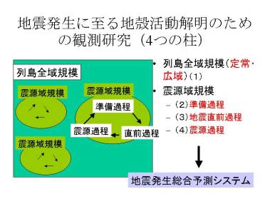
Fig. 2. Study and observation of the processes in the earth's
crust leading to earthquakes.
● Individual Researches
1. Laboratory and numerical experiments on asperity and aseismic
slip area
Recent
studies of earthquake source processes and geodetic observations indicate that
seismic slip event, afterslip, and episodic aseismic event occur in different
areas on a plate boundary. Slip modes seem to be determined by heterogeneous
frictional properties and interaction of different frictional behaviors.
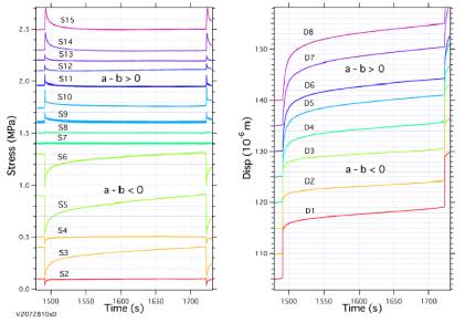
Slip
experiments were performed in a direct shear apparatus using large granite
blocks. The length of the pre-existing fault surface is 100 cm. We insert a
thin Teflon sheet along half section of the fault resulting in
velocity-strengthening (a-b>0). The other half section with
velocity-weakening behavior (a-b<0) acts as an asperity. Local displacements
and shear stresses are measured at many points along the fault. Dynamic rupture
starts from the asperity with rapid stress drop and penetrates into the
velocity-strengthening area, where coseismic slip decreases with increasing
distance from the asperity (Fig.3). In the velocity-strengthening area, the
stress rapidly increases during the dynamic event, and then afterslip occurs
with gradual stress relaxation. At a point sufficiently remote from the
asperity, only afterslip occurs without coseismic slip. Next we average the
displacements and the shear stresses over each of asperity and
velocity-strengthening area, and compare them with the numerical simulation
with the two degree-of-freedum block-spring model. The numerical simulation
quantitatively reproduces the slip behavior found in the laboratory experiment.
Fig. 3. Changes in shear stress (left) and displacement
(right) on a large-scale simulated fault with heterogeneous frictional
property. In the velocity-strengthening area (a-b>0), afterslip occurs
with gradual stress relaxation.
2.
Deformation Process of Island Arc Crust and Active Fault Researches
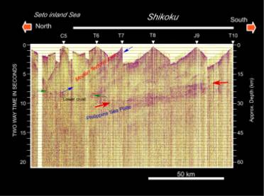
The
research on the detailed lithospheric structure using the controlled seismic
sources has been performed by collaboration of Japanese universities, Japan
Marine Technology Center, and University of Texas under the initiative of
Earthquake Research Institute. The deep seismic profiling was carried out
across central Japan in 2001 and southwestern Japan in 2002. The detailed
lithospheric images beneath Shikoku, including the deep to shallow seismic
profiles across the Median Tectonic Line, were obtained (Fig. 4).
Fig. 4. Deep
seismic profile across Shikoku by low-fold reflection method.
3. Geoelectromagnetic observations and
resistivity structure
Electromagnetic observations reveal subsurface conditions
such as stress, temperature and fluid motion through piezomagnetic, thermal
magnetic and electrokinetic phenomena. Resistivity is sensitive especially to
existence of interstitial fluids and their connectivity. Then, while performing
and promoting cooperative field experiments for electromagnetic monitoring and
resistivity structure determination, we try to elucidate physical process which
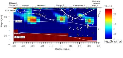
lies between respective fundamental processes and the observations. In Fig. 5,
crustal water content is estimated from the resistivity structure beneath
Tohoku backarc area (cf. 5-2, Fig.2), based on results of laboratory
experiments for rock and water resistivity and crustal temperature structure
estimated from surface heat flow distribution. We are also developing new
techniques of field experiments, data processing and 3-D resistivity inversion.
Fig.5. Water content distribution in the crust, which is estimated
from 2-D resistivity cross section beneath active Tohoku backarc area (cf.
6-2, Fig.2).Also shown are seismicity data after Umino et al.(2000)
(circles), S-wave reflectors (squares) & P-wave scatterers (stars)
determined by Asano(1998), seismic reflection result after Hirata et
al.(1999), and seismic refraction result after Iwasaki et al.(1999).
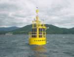
4. GPS Researches on Crustal Deformation
Process
GPS can be used for various applications. Especially
real-time kinematic (RTK) application is now being developed for satisfying
needs of monitoring crustal deformation more rapidly in real-time manner or
estimating accurate position of floating platform. As one of such applications,
we have developed a tsunami detection system using RTK-GPS (Fig. 6). Another
application of RTK is called Virtual Reference Station which uses GEONET as
base stations for producing virtual phase signal nearby observing site, which
enable observer to locate the position without their own base station.
Fig.6. Tsunami detecting system using RTK-GPS
established onshore of Ofunato City.
5. Numerical simulation of seismic cycles
We conduct
numerical simulation studies of recurrence of large interplate earthquakes
using laboratory-derived rate and state-dependent friction laws. Episodic
aseismic slip events (silent earthquakes) found by geodetic observations can be
simulated with the model. When the shear stress on a fault obeys the friction
law, a critical fault size for the occurrence of seismic slip can be defined as
a function of frictional constitutive parameters. Episodic aseismic slip events
occur when the patch size with velocity-weakening frictional property is
comparable with the critical fault size.