Kimihiro Mochizuki
Marine Seismology @ ERI, U-Tokyo
Nankai Trough(off Kii Peninsula)
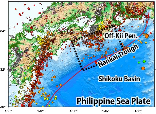
In the Nankai Trough off southwest Japan, the Philippine Sea Plate is subducting under the Eurasian (Amur) Plate at a rate of about 4 cm per year toward the northwest, causing a variety of fault slip events ranging from normal earthquakes to slow slip events. Magnitude 8 class earthquakes repeatedly occur with a recurrence of about 100 to 200 years, the closest being the Tonankai earthquake in 1944 and the Nankai earthquake in 1946.
Mochizuki, K., K. Nakahigashi, A. Kuwano, T. Yamada, M. Shinohara, S. Sakai, T. Kanazawa, K. Uehira and H. Shimizu, Seismic characteristics around the fault segment boundary of historical great earthquakes along the Nankai Trough revealed by repeated long‐term OBS observations, Geophys. Res. Lett., DOI:10.1029/2010GL042935, 2010
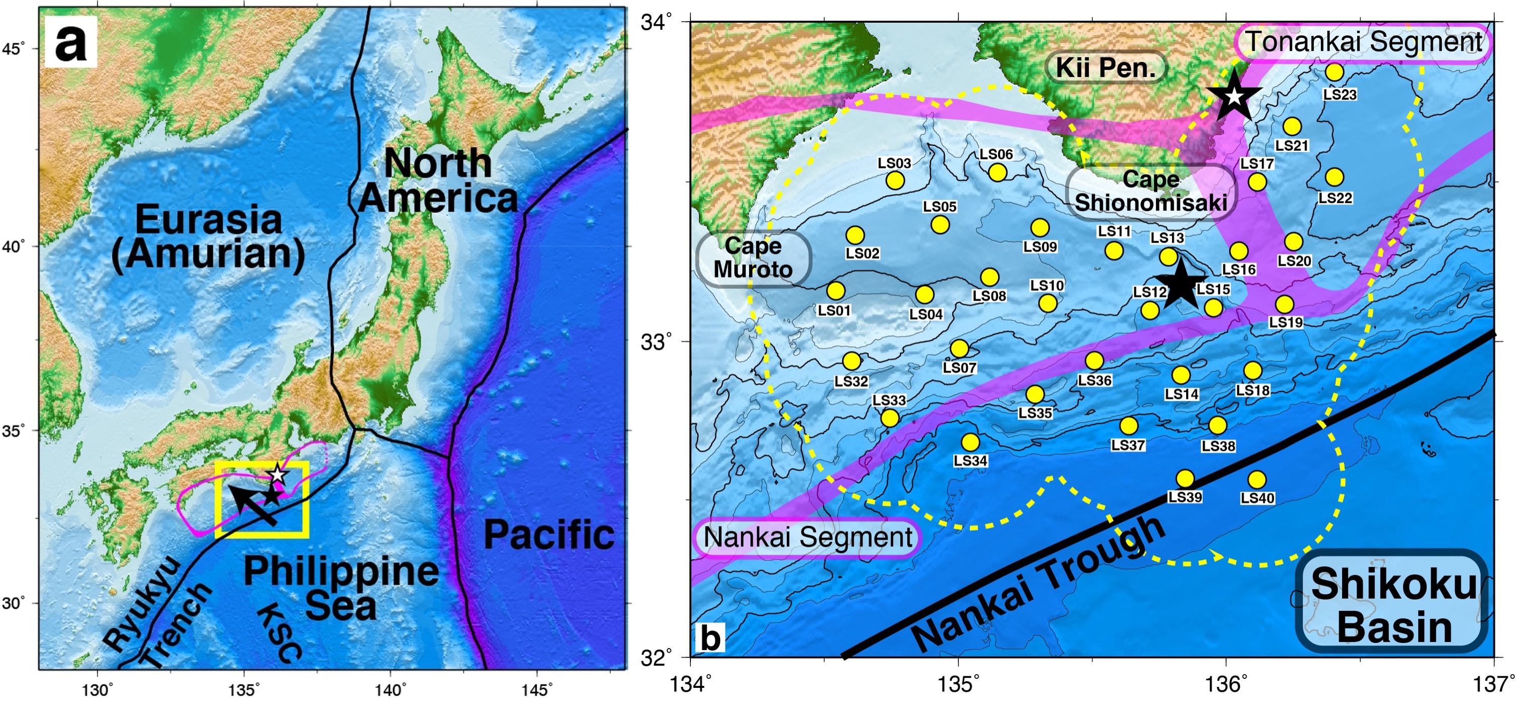
Offshore seismic observation in the fault boundary region of the megathrust earthquakes along the Nankai Trough off the Kii Peninsula
Taking the 1944 Tonankai and 1946 Nankai earthquakes as examples, the source faults of the great earthquakes along the Nankai Trough (the area surrounded by pink in the figure) have their source fault boundaries off the Kii Peninsula. In order to understand the details of the seismic activity around this fault boundary and its seismological properties, offshore seismic observations were carried out using ocean bottom seismometers (yellow circles in the right panel). Since regular seismic activity along the Nankai Trough is extremely low compared to, for example, that along the Japan Trench, repeated observations were carried out for five years.
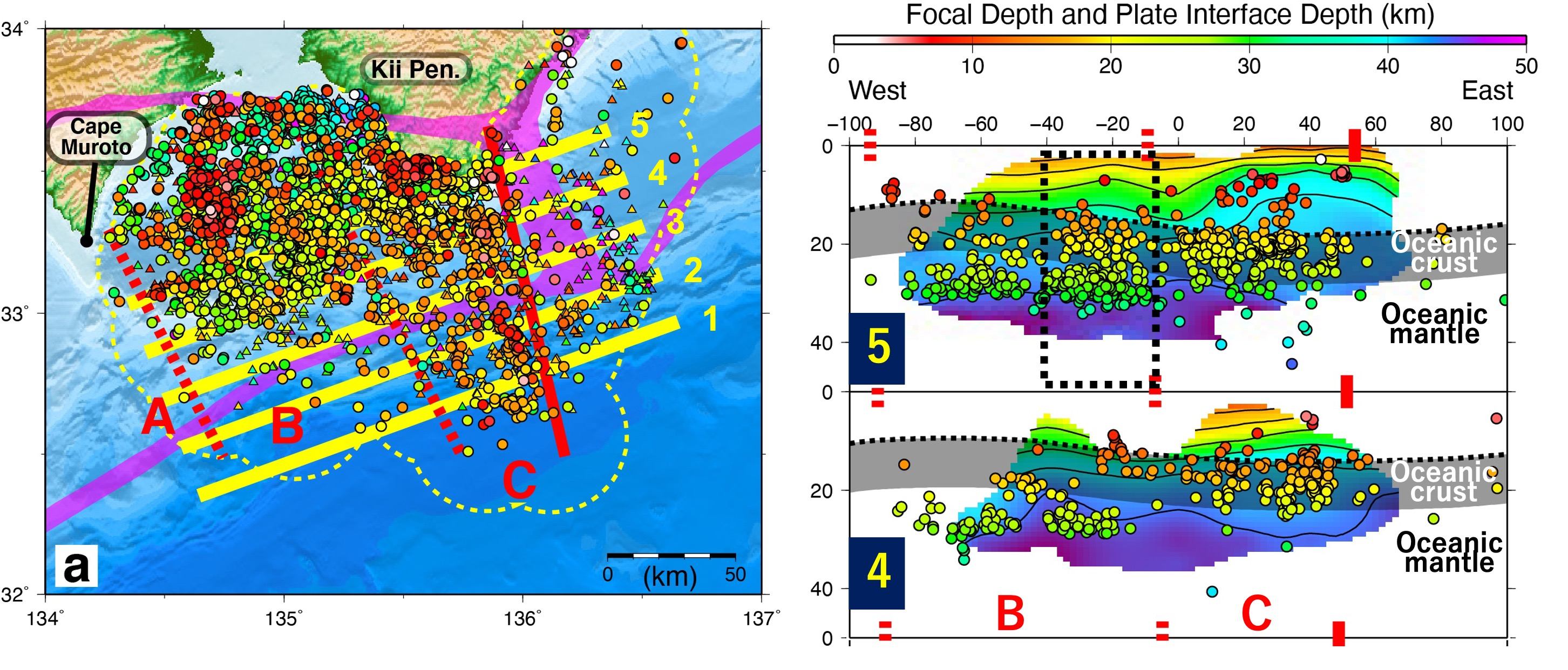
Seismic activity in the fault boundary region of the megathrust earthquakes along the Nankai Trough off the Kii Peninsula
Seismic activity in the boundary area of the megathrust faults is extremely low on the Tonankai side of the boundary. On the Nankai side, seismic activity extends to the trough axis off the Kii Peninsula (region C in the left panel), with off the Kii Suido between Shikoku and the Kii Peninsula (boundary of B and C in the left panel) as the boundary. Most of the earthquakes off the Kii Suido (B in the left panel) occurred within the megathrust fault area. Almost no seismic activity is seen in the west of Cape Muroto (region A). Looking at the depth profile of the seismic activity, in the offshore area from the fault boundary to off Kii Suido (region C in section 4 in the right panel), seismic activity occurs in the subducting oceanic crust, whereas seismic activity occurs in the subducting oceanic mantle on the west side (region B, section 4 in the right panel). Further landward in the cross-section beneath the coastline area (section 5 in the right panel), seismic activity occurs at different depths in the oceanic crust and the oceanic mantle in the boundary area between regions B and C (section 5 in the right panel, black dotted line).

Spatial distribution of seismic activity in the fault boundary region of the megathrust earthquakes along the Nankai Trough off the Kii Peninsula
Looking at the spatial distribution of the seismic activity in the oceanic crust and the oceanic mantle seen above (left panel: in the oceanic crust, right panel: in the oceanic mantle, upper panel: cross section inside the black square in the panels), offshore of region C, the seismic activity in the oceanic crust reaches up to the Nankai Trough axis, and the activity in the oceanic mantle becomes visible when approaching the land area. Seismic activity in the oceanic mantle is generally observed in region B, and the activity in the oceanic crust spreads within the area as it approaches the land.