The surface earthquake fault of the 11th April 2011 earthquake in Hamadoori Fukushima pref.
Report3: Preliminary report on trench excavation across the coseismic surface rupture associated with the 2011 Fukushima Prefecture Hamadori earthquake (M7.0)
*Images/Figures all rights reserved
By: Tatsuya Ishiyama (ERI), Nobuhiko Sugito (Research Center for Seismology, Volcanology and Disaster Mitigation, University of Nagoya), Tomoo Echigo (Geo-Research Institute), Hiroshi Sato (ERI)
Introduction
A month after March 11 gigantic Tohoku earthquake (M9.0), M7.0 earthquake occurred at a depth of 5 km on April 11 beneath coastal area of Fukushima prefecture (JMA, 2011). Focal mechanism of the mainshock indicates that this earthquake is a normal faulting event beneath the Abukuma Mountains. Based on field reconnaissance, about 11-km-long coseismic surface ruptures were recognized along the Shionohira fault mapped prior to this event and are interpreted as a surface manifestations of its reactivation associated with normal faulting event (c.f., Ishiyama et al., 2011; Sugito et al, 2011). This strongest in-land earthquake event occurred after the Tohoku earthquake may imply its mechanical relation to the gigantic megathrust earthquakes. In this report we introduce preliminary results of a trenching survey across the coseismic surface ruptures at Shionohira site, conducted from 29 July to 25 August, to resolve timing of paleoseismic events along the Shionohira fault.
Trench evacuation
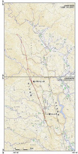
fig1: Distribution of coseismic surface rupture associated with the 2011 Fukushima prefecture Hamadori earthquake (M7.0) on 11 April. Red lines indicate locations of the surface ruptures found by the survey from 12th to 14th April. Red dotted lines are their approximate locations. Black lines denote location of estimated active faults mapped by Nakata and Imaizumi (Eds) (2002). 1/25000 topographic maps published by Geographical Survey Institute of Japan are used as a basemap.
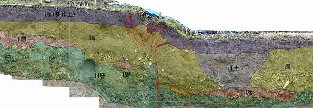
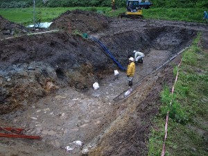
Trench excavations were carried out at two sites (Ichinokura and Shionohira sites) in Iwaki, Fukushima. At Shionohira site a 2-m-deep trench was excavated across the coseismic fault scarp emerged on the alluvial plain on the eastern flank of the Abukuma Mountains (Figure 1; Photo 1). On the trench walls crosscutting the scarp we observed pairs of steeply dipping normal faults that deform Neogene to Paleogene conglomerates and unconformably overlying, late Quaternary to Holocene fluvial units (Figure 2). The altitudes of the normal fault plane are measured as N31°W 82°S in northern wall and N39°W, 90°W in the southern wall, respectively. Sense of fault slip observed on the trench walls (large dip-slip with small sinistral component) is consistent with that estimated from coseismic surface ruptures. Interestingly styles of deformation seems strongly controlled by mechanical properties of fluvial units; brittle deformation concentrated within a narrow fault zone in the lower Unit I and II and older bedrock (Unit III) mainly composed of coarse sands and gravels, and ductile deformation marked by drape folds in the upper Unit I composed of sandy silts. Fault throw estimated from separation of piercing points on lower Unit I and vertical structural relief on folded upper Unit I is consistent with topographic height of the coseismic fault scarp at the trench site. Contrastingly, vertical separation of Unit II, unconformably overlain by Unit I, is measured as about 1.5 m, twice as large as coseismic vertical component of slip, indicative of penultimate seismic event prior to the 2011 earthquake. Abrupt thickening of overlying Unit I may also suggest preexisting topographic relief prior to its deposition. Future work includes radiocarbon dating in the future to determine stratigraphy of units exposed on the trench walls and to define timing of paleoseismicity on the fault.
Plan in the future
We will later make a radiocarbon isotopic age determination, using collected samples, and try find out the past activity date of Shionohira fault, by defining the stratigraphic succession of deposit that appeared on the trench
Acknowledgment
We thanks to T. Ito (Teikyo Heisei University) and K. Kano (Shizuoka University) and T. Suzuki (Tokyo Metropolitan University) for discussions in the field. Field works by H. Maruyama (Nagoya University), Y. Nakayama (ERI), N. Takamatsu (Tohoku University) are helpful.
Referrence
- Ishiyama, T., H. Sato, N. Sugito, T. Echigo, T. Ito, N. Kato, T. Imaizumi, 2011, Tectonic setting of coseismic surface rupture associated with the 2011 Iwaki earthquake, Japan Geoscience Union 2011 annual meeting, MIS036-P10.
- Japan Metrological Agency, 2011a, 15th report on 2011 Tohoku Earthquake: http://www.jma.go.jp/jma/press/1103/13b/201103131255.html
- Japan Metrological Agency, 2011b, 35th report on 2011 Tohoku Earthquake: http://www.jma.go.jp/jma/press/1104/11b/201104111820.html,
- Nakata. T and Imaizumi. T. (Eds), 2002, Digital active fault map of Japan (in Japanese), DVD-ROM2, appended figure 1, 60pp., University of Tokyo Press, Tokyo.
- Research Group for Active Faults, 1991, Active Faults in Japan: Sheet Maps and Inventories (in Japanese), 437 pp., Univ. of Tokyo Press, Tokyo.
- Sugito, N., T. Ishiyama, T. Echigo, H. Sato, N. Kato, T. Imaizumi, 2011, Preliminary report on slip distribution of surface rupture associated with the 2011 Iwaki earthquake, Japan Geoscience Union 2011 annual meeting, MIS036-P1.
Report2: 11th to 13th April field survey report
(By: Tatsuya Ishiyama, Hiroshi Sato (ERI), Tanio Ito (univ. Teikyo Heisei), Nobuhiko Sugito (univ.Nagoya Research Center for Seismology, Volcanology and Disaster Mitigation), Tomoo Echigo (Geo-Research Institute), Naoko Kato (ERI),Toshifumi Imaizumi (univ. Tohoku)
Introduction
M7.0 (temporary) earthquake with depth 5km occurred around 16:00 11th April at Hamadoori Fukushima prefecture (JMA2011). The surface earthquake fault was found along the active fault, known as Idozawa Fault, by the field survey done from the day after earthquake occurrence (12th to 14th).
Below is the addition and changes from the first report provided on 13th.
Surface earthquake fault of the Fukushima Hamadoori earthquake on 11th April 2011
From 12th to 15th April, a field survey was held to see if there was a surface earthquake fault or not. As a result, intermittent distribution of a high-angle westerly dip or otherwise an almost vertical fault plane was found in the 11km between Tabito and Tabiudo of the Oodaira Tsunaki in Iwaki city. (fig.1). The strike of the tectonic scarp generally indicates in the vicinity of N10ºW, vertical displacement at the lowering of west side is about 0.8-1.8 m, and the right-lateral fault displacement is within/out 30cm. It is assumed that the surface earthquake fault is considered to have right acheleon formation.
Surface earthquake fault appeared along the far most west side fault amongst the several fault lines suggested by Active Fault Research (1991) (fig1 and images). On the other hand, we surveyed the several lines that runs across the fault lines on the east side, id est a geologically defined fault: Izawa fault, but no Surface earthquake fault was found.
Fig.1 Distribution of the surface earthquake fault of the earthquake (M7.0) on 11th April 2011 at Hamadoori Fukushima pref. The red line is the distribution of the surface earthquake fault found by the survey from 12th to 14th April, the red dotted line is the location of the surface earthquake fault assumed mainly from the geological formation, and the green circle indicates the location where surface earthquake fault was confirmed. The orange line is the route of field survey and the black line indicates the location of estimated active fault by Nakada and Imaizumi (2002). The map is 1/25000 topography issued by Geographical Survey Institute.
Proposition of Shionohira fault (provisional title)
Active Fault Research (1991) is defining the several fault lines including the above-mentioned Idosawa fault as “Idosawa fault”in a lump. But on the other hand, faults that distribute along the earthquake fault this time, have an almost vertical structure with cataclasite and fault gouge having Gozaisho metamorphic rocks as protolith, and is obviously a different structure from Izawa fault (Watanabe, Sato, 1935). Therefore, here, we name the normal fault located in the west most side out of “Izawa fault” (Active Fault Research, 1991) as“Shionohira fault”tentatively from Shionohira Tabito-cho, Iwaki city where the maximum vertical displacement was observed. According to Kubo et al.(2007), Shionohira fault will be extending more toward the south than the area where surface earthquake fault appeared this time. Therefore, according to the definition in this, surface earthquake fault this time has appeared along the part of “Shionohira fault”.
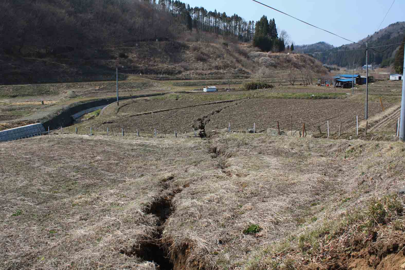
Image1: Loc 7. Tsumiki Toono Iwaki city. The surface earthquake fault running across the paddy field on the bottom of the valley. Facing north-northwest. Aperture rift evolves over the top of the cliff surface. The hinge indicated by cliff line of the bending and the aperture rift extends from city road in front to the slope in the back with right echelon formation. The road surface cliff height In front is 50 cm. The amount of horizontal extension measured from the off-set of channel is 6 cm.
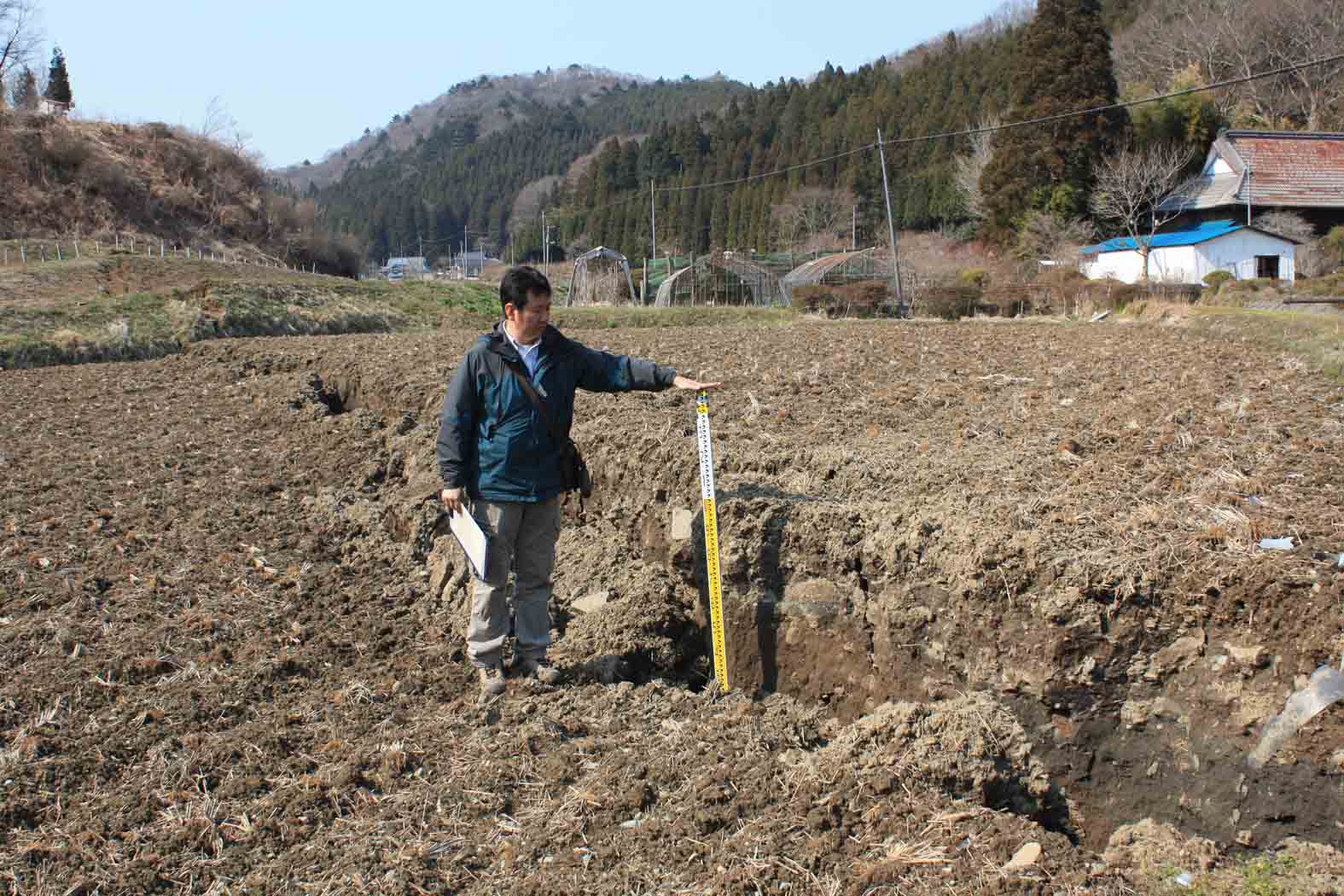
Image2. Loc7. Tsumiki Toono Iwaki city. The surface earthquake fault running across the paddy field on the bottom of the valley. Facing north-northwest. An almost vertical fault surface appears along the aperture rift.
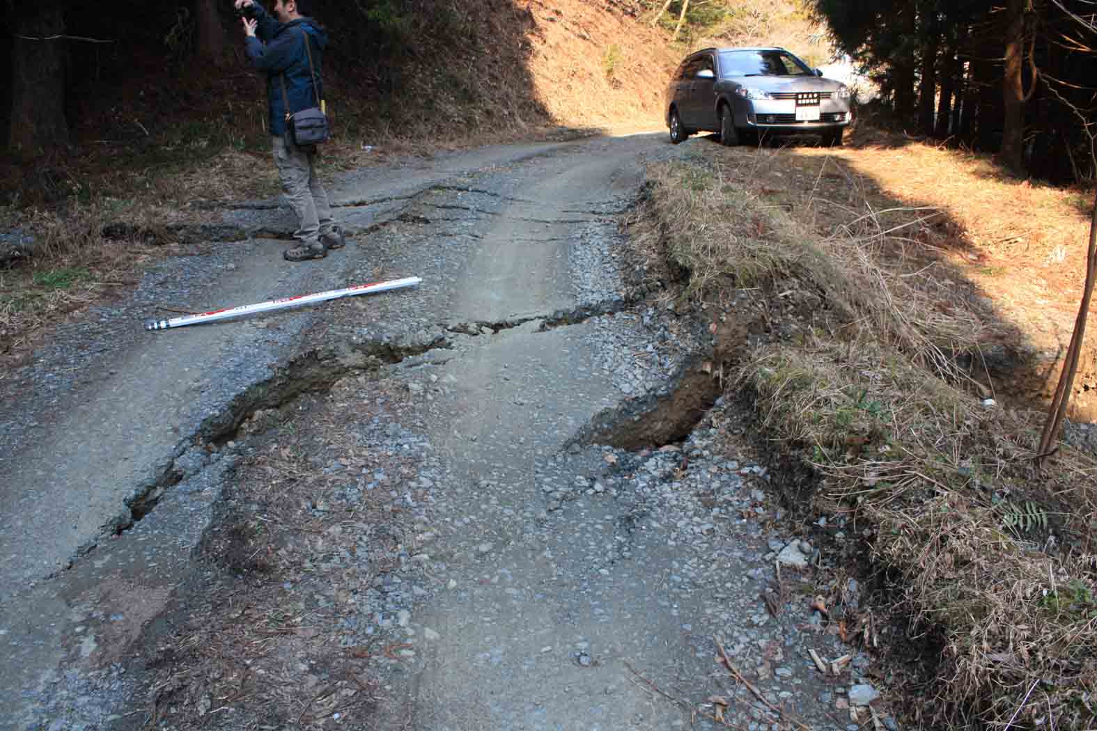
Image 3 Loc 8. Tsumiki Toono Iwaki city. The surface earthquake fault cutting across the pavement of a road. The aperture rift echelons to a remarkable extent. Against the strike of the aperture rift generally indicates in the vicinity of N22ºW, the strike of the aperture rift in the middle of the image is N85ºW, which differs in a huge scale. The cliff height is 50 cm. It is near the northern limit of the surface earthquake fault found this time.
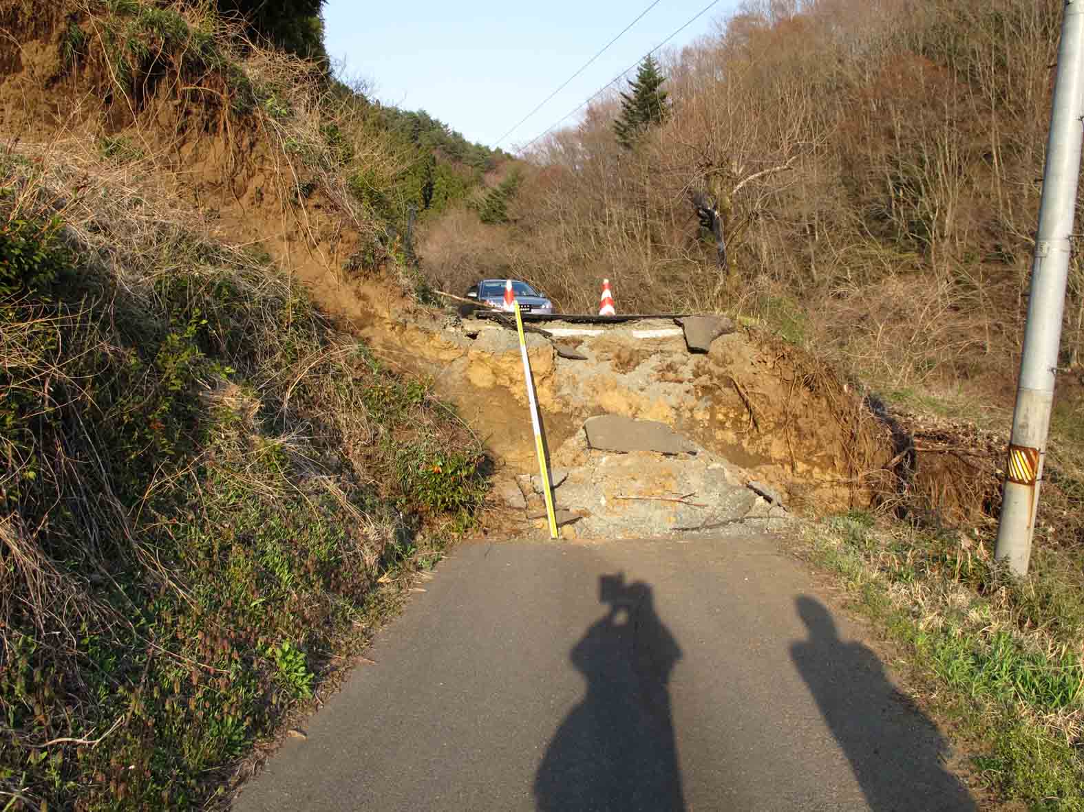
Image4 Loc 12. The surface earthquake fault running across the road in the east of Shionohira village in Shionohira Tabito Iwaki city. Facing east. The cliff height is 1.8 km. The strike of fault surface is N20ºW, the dip is 70Wº. The observed fault striation has two directions:60ºS and 85ºS, and is becoming low angle from the above.

Image 5 Loc 13. Shionohira Tabito Iwaki city. It corresponds to north-north west extension of the surface earthquake fault. The earthquake fault splits in two stria as it forms in right echelon, and runs across the paddy field. The summed vertical displacement at the place of the two stria fault overlapping is about 2.3 m, and the left-lateral fault displacement is within/out 0.5m.
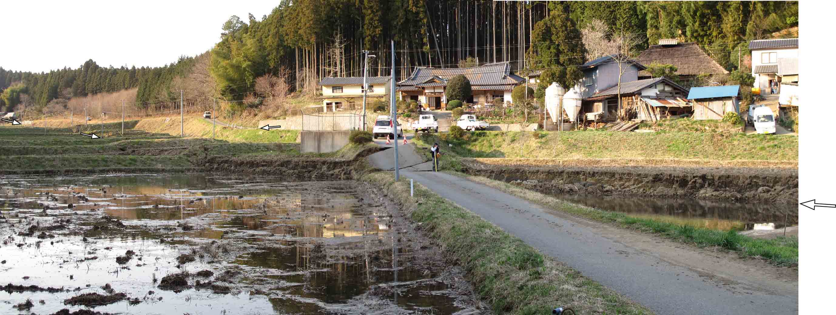
Image6 Loc 13. Shionohira Tabito Iwaki city. The surface earthquake fault extending northwest in image 6. The cliff-height on the pavement of the road is approx:1.3
Future plans
Hereafter, the plan is to try clarifying the more accurate location of the surface earthquake fault and distribution of co-seismic displacement, taking the above result and tasks into account.
Acknowledgement
I would like to express my gratitude to Lecturer. Tsuyoshi Sato (univ. Teikyo Heisei) and Project Researcher. Toshio Nakayama (ERI) for their contribution at the field survey.
Referrence
- Active Fault Research comp.(1991) Active Faults in Japan, University of Tokyo Press,437pp.
- Japan Metrological Agency (2011) 35th report on 2011 Tohoku Earthquake :http://www.jma.go.jp/jma/press/1104/11b/201104111820.html
- Kubo.K, Yanagisawa.Y, Ymamoto.T, Nakae.S, Takahashi.H, Toshimitsu.S, Sakano.Y, Miyaji.Y, Takahashi.M, Oono.T, Komazawa.M (2007) Seamless Digital Geological Map of “Shirakawa”, Geological Survey of Japan.
- Nakata.K and Imaizumi.T comp. (2002), Katsudansou shousai Digital map, University of Tokyo Press, DVD-ROM2,appended figure 1, 60p.
- Watanabe.H, G.Sato,(1935)Seamless Digital Geological Map of “Nakoso” Geological Survey of Japan
M7.0 (temporary) earthquake with depth 5km occurred around 16:00 11th Aprill at Hamadoori Fukushima prefecture. The surface earthquake fault was found along the active fault, known as Idozawa Fault, by the field survey done from the day after earthquake occurrence (12th).
(By: Tatsuya Ishiyama, Hiroshi Sato, Naoko Kato (ERI), Kouji Yagi (univ.Yamagata), Toyohiko Miyagi (univ. Tohoku Gakuin), Toshifumi Imaizumi (univ. Tohoku))
- Geological Background
Western Iwaki city of Abukuma-sanchi is the focal region. Metamorphic rocks and Cretaceous strata, granite and epidiorite are distributed in this area, and also the fore-arc deposit with unconformity in Tertiary is distributed (Kubo et al. 2007). The main structural trend of the above tertiary deposit is NNW-SSE, and Idosawa fault was described as the fault that limits the distribution of Neogene tuff (Sugai et al. 1957, Mitsui 1972, Suzuki et al.2005). Active Fault Research (1991) described the Idosawa fault as a fault mainly consists of a trace of 3 striations, and the overall length of the trace is 20km. Only the fault in south has lowering on east side, which is different from how it is in the north of the city.
Nakada and Imaizumi edition (2002) is mainly describing the faults consists of a trace of 2 striations, and mostly said to be a fault with lowering on the west side. Additionally, the fault at the southern most part (by the Active Fault Research(1991)) is not considered as an active fault. (click the image to enlarge)
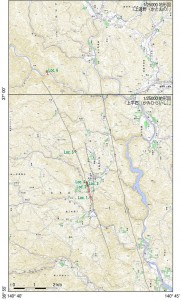
Distribution of the surface earthquake fault. The red line is the distribution of the surface earthquake fault found by the investigation on 12th April and the green circle indicates the location of the image. The black line indicates the location of estimated active fault by Nakada and Imaizumi (2002). The map is 1/25000 topography issued by Geographical Survey Institute.
- Surface earthquake fault involved in the Fukushima Hamadoori earthquake on 11th April 2011
12th April, day after the earthquake, a field survey was held to see if there was a surface earthquake fault or not. As a result, distribution of a fresh fault scarp was found in the 6.4 km between Tabito and Tabibito of the Oodaira Toonomachi in Iwaki city. The strike of the tectonic scarp generally indicates in the vicinity of N10ºW, vertical displacement at the lowering of west side is about 0.8-1.5 m, and the right-lateral fault displacement is within/out 30cm. In some points, high-angle westerly dip or otherwise an almost vertical fault plane are outcropping.
And generally has aperture rift on top of the scarp surface and accompanies an antithetic normal fault that cuts the scarp surface.
Additionally, it almost won’t accompany compressible structure. From these aspects, the found tectonic scarp was a surface deformation along with the fault movement of the normal fault in westerly dip. In Loc.1,4,6 The tectonic scarp is emerging at the bottom of the valley, and is difficult to consider that it is a normal fault structure according to the slope flow such as landslide. Therefore, the tectonic scarp found in this earthquake, is assumed to be a surface earthquake fault formed in the upward extend of the source fault.
The surface earthquake fault seems to be distributed along the most eastern trace, among the faults indicated as Idosawa fault by the past research. On the other hand, Loc. 6 on the northern tip is not always consistent with this trace. And the fact that the vertical displacement of Loc.6 is almost the same with other points (approx.1.2m), and from the aftershock distribution, it is assumed that there is a high possibility of more surface earthquake fault emerging in the north side. In this wise, it is necessary to have further consideration on the relation between the distribution range of the surface earthquake fault and the existing mapping.
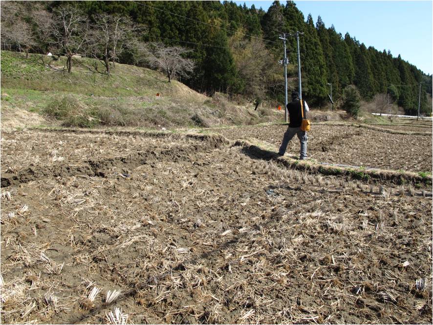
Loc1. Tabibito Tabito-cho Iwaki city The surface earthquake fault running across the paddy field on the bottom of the valley. Facing south. Aperture rift evolve over the top of the cliff surface. Cliff height is 80cm
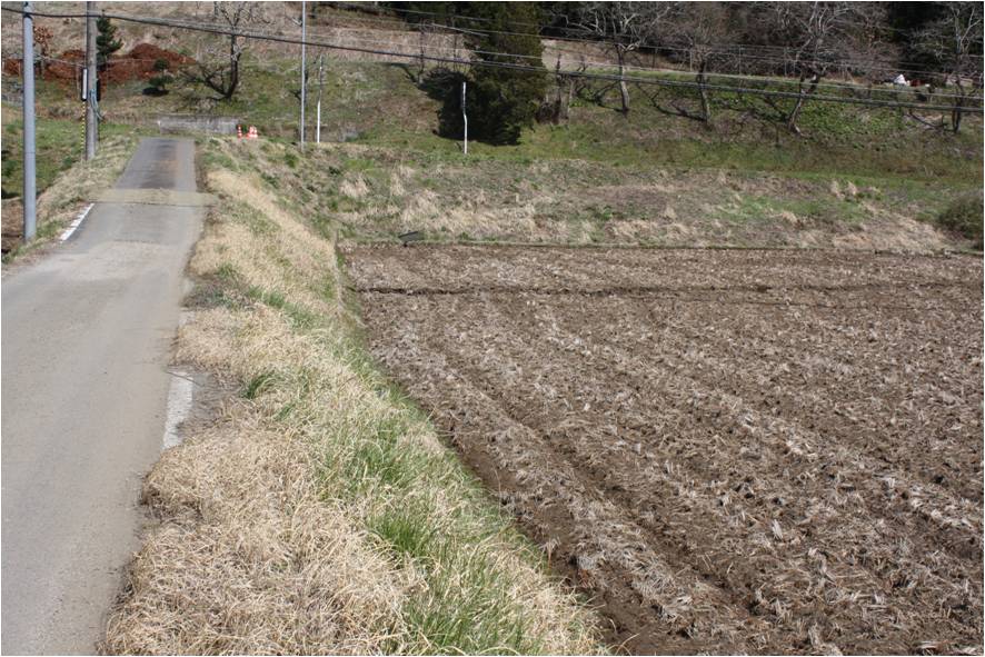
Loc1. Tabibito Tabito-cho Iwaki city The surface earthquake fault running across the paddy field on the bottom of the valley. Facing east. It describes that the fault was with the right-lateral fault (approx.30cm) from the ridge of farm road and puddle field.
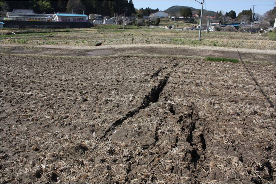
Loc1. Tabibito Tabito-cho Iwaki city The surface earthquake fault running across the paddy field on the bottom of the valley. Facing north. The strike of fold scarp occurs with the aperture rift and normal fault forms in side by side.
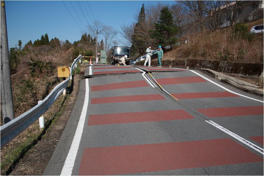
Loc2. Kuroda Tabito-cho Iwaki city The surface earthquake fault running across the road in the north of Tabito middle school. Facing east.
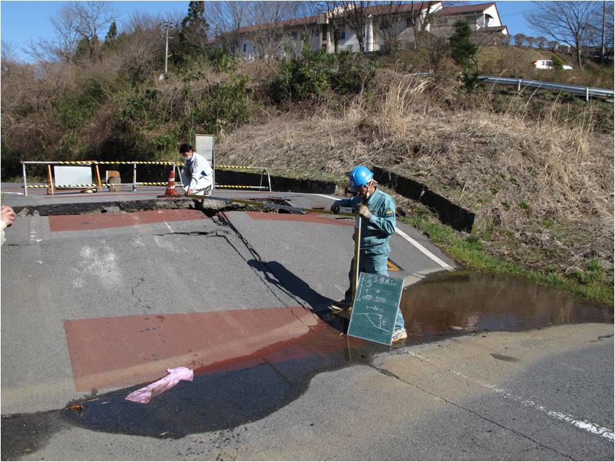
Loc3. Kuroda Tabito-cho Iwaki city The surface earthquake fault running across the road in the north of Tabito middle school. Facing east. Cliff height: approx.1.1 m, Right-lateral fault displacement: approx.30cm.
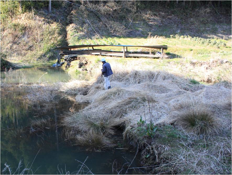
Loc4. Kuroda Tabito-cho Iwaki city The surface earthquake fault cutting across the river bed of Bettougawa. Facing north. Flooding was caused because the upper stream was relatively lowered. The surface earthquake fault runs across the Bettougawa and continues to the hillside on the left shore.
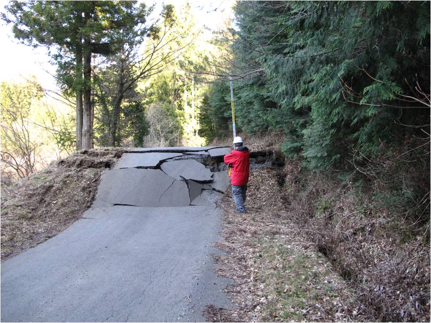
Loc5. Kuroda Tabito-cho Iwaki city The surface earthquake fault cutting across the pavement of a road. Facing east. Cliff height: approx.1.5m, Right-lateral fault displacement: approx.50cm.
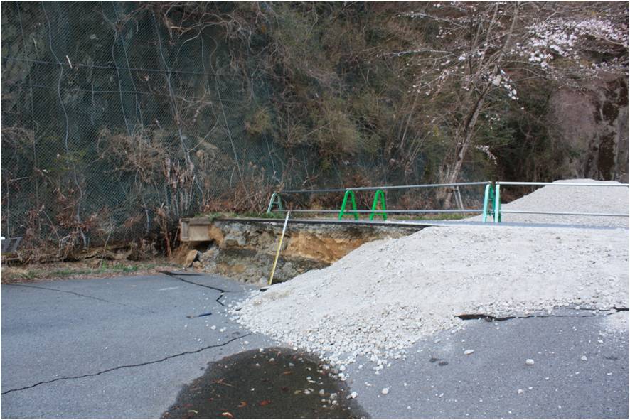
Loc6. Oodaira Toono-cho Iwaki city The surface earthquake fault cutting across the road surface of prefectural highway (Gosaisho-kaido). Facing East. The fault surface is almost vertical. Cliff height: 1.3m, Right-lateral fault displacement: approx. 20cm.
Aftershock distribution and active fault
Aftershocks are distributed more on the west of the Idosawa fault of the Nakata and Imaizumi edition (2002). The southern tip almost corresponds with the west extension of the fault line of this fault, but in the north, it is distributing up to furthermore km from the northern tip of the fault line.
The focal mechanism of this earthquake is normal fault with tensional axis pulling toward west-southwest – east-northeast, and that is shallow crustal earthquake. Usually, this area has less seismic activity and the normal fault seismic activity became active after the off Tohoku pacific earthquake. Active faults distributed in Tohoku area are mostly reverse fault, and this was the first time to see a normal fault of a massive earthquake in Tohoku. This is considered that peculiar tensional stressed field on the side overriding forearc wedge was build by the massive megathrust of M9.
Future plans
Plan is to try clarifying the emerging region of the surface earthquake fault, taking the above result and tasks into account.
Referrence:
- Active Fault Research comp.(1991) Active Faults in Japan, University of Tokyo Press,437pp.
- Kubo.K, Yanagisawa.Y, Ymamoto.T, Nakae.S, Takahashi.H, Toshimitsu.S, Sakano.Y, Miyaji.Y, Takahashi.M, Oono.T, Komazawa.M (2007) Seamless Digital Geological Map of “Shirakawa”, Geological Survey of Japan.
- Mitsui.S (1972), On a few Problems Concerning the Geological Structures in the Joban Coal-Field, Departmental Bulletin Paper Tohoku University, 73, 87-96.
- Nakata.K and Imaizumi.T comp. (2002), Katsudansou shousai Digital map, University of Tokyo Press,DVD-ROM2,appended figure 1, 60p.
- Sugai.K, Matsui.H, Sato.S, Kitagawa,Y, Sasaki.M, Miyashita.M, Kawauchi.H, (1957) Joubantanden chishitsuzu narabini setsumeisho. Fig.1 Japan coalfield, Geological Survey of Japan, 143p
- Sudo.I, Yanagisawa.Y, Ogasawara.K (2005),Joban chiiki oyobi sono shuhen no daisankei no chishitu to nenndaisoujo, Bulletin of the Geological Survey of Japan, 56, 375 – 409.

