(05/11/01)
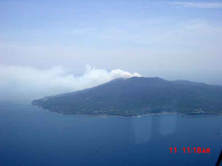
According to JMA's Weekly Reports and Volcano Observation Reports on the volcanic activity on Miyakejima, a plume of steam including abundant SO2 had been continuously emitted from the summit caldera as high as 500 to 2,000 m above the rim. Gray-colored cloud had not been observed since the 19 March morning, when a small-scale eruption probably took place, being associated with tremor events and following acoustic signals of the previous night. GPS of JMA showed steady continuous shrinkage of the volcano, though the rate was lower than before last September.
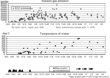
Though a low level of seismicity had continued in Miyakejima, the quake with M2.8 occurred at 02:18 on 7 May. No any other manifestation of the activity was observed before and after the quake. Four hundred-and-forty-six of small low-frequency earthquakes occurred on May 5. COSPEC analysis by JMA indicated still continuous emission of SO2 as abundant as 33,000 to 46,000 ton a day.
Geologists of universities and Geological Survey of Japan had continued the air inspection, three times a week, who are flying from Tokyo. Very small collapses of the caldera rims occurred rarely, but the caldera scale had hardly increased since last September.
(02/12/01)
National Coordination of Volcanic Eruption Prediction, chaired by Prof. Yoshiaki Ida (Univ. of Tokyo) issued the comments on the Miyakejima activity on February 5, 2001, as follows.
Huge amount of volcanic gas has been emitted from the summit crater at Miyakejima.
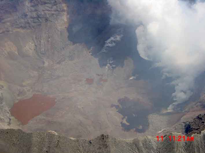
No typical eruptions had taken places except for the emission of volcanic gas since last October. Ash fall was reported in only the places nearby crater. The temperature of the active crater had increased by December, 400 degree C in late-December, associated with slight incandescence in nights, the latter which disappeared in late-January.
Ground deformation implying shrinkage of Miyakejima, which began in last July, had declined, though it has still continued in the smallest level. Seismic activity had been low in level since last September, although low-frequency earthquakes occurred in the shallow part in late-January.
The height of smokes emitted from the summit crater ranged from several hundreds to two thousand meters above the crater. The amount of SO2 emitted had been maintained in a range from about 20 to 50 kiloton a day. High abundance of SO2 often had been observed even at the volcano flanks depending on weather condition. Most of SO2 is considered to result from degassing from magma. At the present, there is no sign indicating the decrease in abundance of SO2 emitted.
As the activity emitting SO2 is considered to still continue at Miyakejima, should pay attention to volcanic gas. Also attention to mud flows is needed when rains.
Link to: Monitoring of volcanic gas at Miyakejima by Geol. Surv. Japan
Information contacts: JMA, Volcano Research Center, ERI, University of Tokyo
(10/16/00)
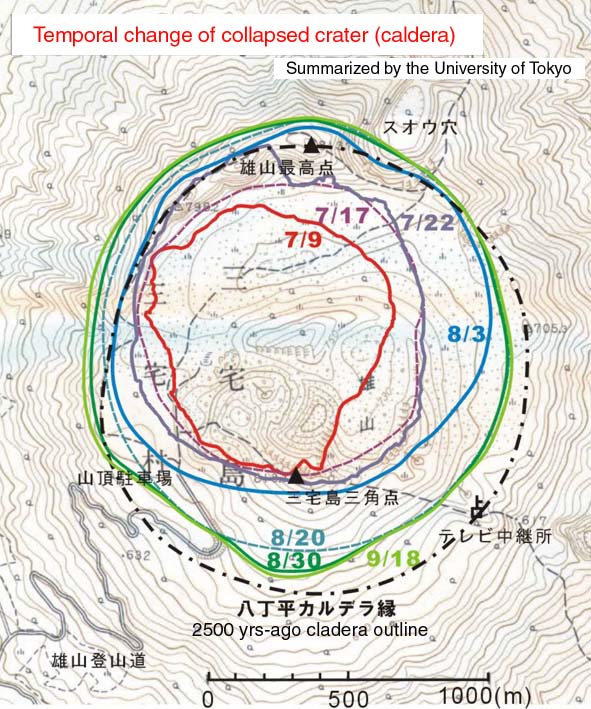
According to JMA, Geological Survey of Japan, and Tokyo Institute of Technology, SO2 flux from the craters within the Miyakejima summit caldera has still continued in high level; 30,000-50,000ton/day. Ash had been emitted continuously in early-September and intermittently in late-September. The subsidence had not been clear after mid-August, although partial collapses of the northern cliff of the caldera took place in late-September. A large pyroclastic cone inclined the southern cliff of the caldera, on which steaming craters are located. The present altitude of the caldera floor is about 230 m according to the laser-distance meter survey from helicopter by ERI.
As SO2 was too high, the Tokyo Metropolitan government to which the Miyakejima belongs decided that nobody stayed in the island during night. By the early October, public workers and researchers had stayed in a boat floating near harbors (hotel-ship system) and landed at the island in daytime. P3C of the Maritime Safety Department watched the activity during the operation. In the early October, the hotel-ship system also stopped and public workers and researchers commuted by small boats between Miyakejima and Kozu-shima, the nearest island to the former. Operation was limited along the road running the coastline, for a short time, only when clear sky, and depending on the direction of the wind.
Electric power was cut when workers of the electric company did not stay in the island, so that most of monitoring equipment was down in night and cloudy-rainy days. Though Earthquake Research Insatiate, University of Tokyo, and other national institutes kept the gathering the real-time data, their aims were hardly filled.
Temporal change in outlines of newly formed cladera
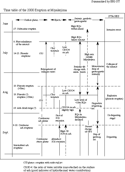
Time table of the 2000 eruption at Miyakejima
Other information on this eruption from ERI (University of Tokyo)
(09/06/2000)
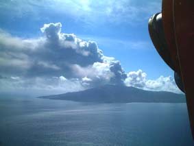
Though seismic activity of Miyakejima had declined since mid-August, deflation of the island that can be estimated by GPS and tiltmeter surveys by Geographical Survey Institute, Japan and National Research Institute for Earth Science and Disaster Prevention had continued with nearly constant rates. After the 18-Agusut eruption, strong flux of SO2 was measured by Tokyo Institute of Technology, JMA and Geological Survey of Japan (more than 1000 ton/day). The strong smell of sulfur was felt widely in the southern Kanto district, including Tokyo and Yokohama. Nine days after the most explosive eruption on 18 August, an eruption sending ash-cloud surges to the wide area of the island took place. According to JMA, volcanic tremor event corresponding to the initiation of eruption started around 4:30 on 29 August. The eruption continued for about 2 hours. Dark-colored eruption cloud rose about 4 km above the summit caldera. Low ash-clouds descended on the slope of the volcano very slowly to the northeastward and southwestward. Geologist group of ERI witnessed the eruption and recorded it in a video from the scientific observation ship (Shin-Kai-Maru). The speeds of the ash-cloud surges (?) were calculated to be 4 to 8 m/s. This eruption is characterized by low eruption-column and by extensive lateral-flowage of low ash clouds from the summit. Small-scale lateral-flow of ash clouds was also observed during the 10-August eruption, though the latter eruption column rose as high as 8 km above the summit.
The ash cloud of this eruption covered the Miyake weather station of JMA, and the temperature was elevated by about 10 degrees. Two geophysicists of ERI who were driving cars in the northeastern part of the island encountered the ash cloud. Although they felt a weak lateral wind sending ash under their cars, they did not felt heat when darkness due to heavy ash drifting enveloped them, and, then, continued driving. Abundant ash deposits prevented their cars to advance and they left their cars, though they did not feel any heat. Some people who stayed in their houses during the eruption were walking on the street. Local government recommended them to stay inside houses when eruption started. ERI inspected the deposits from the ash cloud surges. The deposits were as thin as 7 cm, consisting of very fine sand (ash) without any blocks and pebbles in the coastal area, and showing any difference from air-fall ash deposits of previous eruptions.
National Coordination Committee for Volcanic Eruption Prediction (chaired by Prof. Yoshiaki Ida), which commented several times on Miyakejima volcano since 26 June, issued a comment on 31 August;
"At Miyakejima eruptions has occurred intermittently. After the 18 August eruption, there were eruptive events that issue debris and cinders from several craters, being associated by volcanic tremor and air-shock events repeated several seconds. Fluxing of SO2 has continued. Seismic activity is low in level. Ground movement indicating inflation of island has still continued. The eruption that began at 4:30 a.m. was the largest one next to the 18 August eruption. In this eruption, weak pyroclastic flows descended to NE and SW sides, travelling 5 and 3 km respectively. The NE pyroclastic flows reached the coast. The temperature of the flow was around 30 degree C and the speed was around 10 km/h. The pyroclastic flows are characterized by low temperature flow without force. No typical precursory phenomena were observed in this eruption. The volatile component attached in volcanic ash was enriched in HCl, being compared with the products of the 18 August. Judging from the data of ground deformation, seismic activity, eruption products and volcanic gas, the mechanism of these summit eruptions may be instability of geothermal system created by the summit collapse, and, alternatively, may be interaction of groundwater with an ascending magma.
There is a possibility that eruptions as large as or larger than the 18 and 29 August ones may occur repeatedly. Need the attention to pyroclastic flows. Especially, when magma is involved in eruptions, stronger pyroclastic flows would occur.
Need attention to ballistics, mudflows and volcanic gas. Presently, there is no possibility of flank eruption."
Receiving this comment, the local government decided evacuation of all people living in the island outside the island on 1 September.
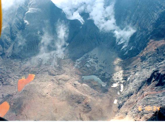
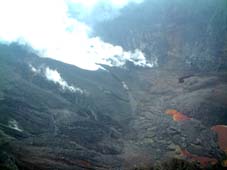
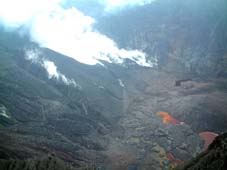
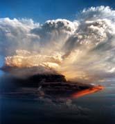
Photos of summit caldera on 3 Sep.
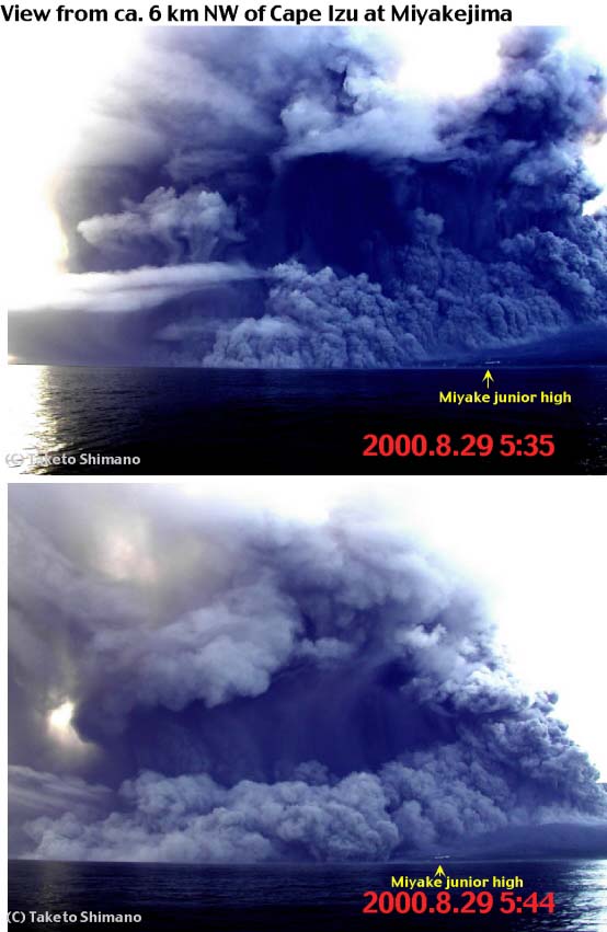
Photos of ash-cloud surges on 29 Aug.
Map showing distribution of ash-cloud surge deposits. Arrows indicate the directions of ash cloud's flowing. Stars inside the caldera represent the location of craters on 25 and 26 August.
(08/23/00)
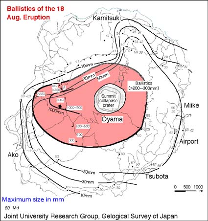
Geological Survey of Japan and Earthquake Research Institute (U. Tokyo) had inspected the eruption products of the latest eruption since 19 August. Ash fell over all area of the island, and the deposit was thicker in the western part due to weak east wind during the eruption. Ballistics that fell in the latest stage of the eruption episode were issued nearly radially from the summit collapsed crater. As the crater rim was lower in altitude in the east and west, ballistics were issued farther in these directions. In the western middle slope of the volcano, ballistics as large as 2 m across attacked cowsheds in a high density, forming many holes in the building roofs and craters in meadows. Though the ballistics contained abundant basaltic bombs as large as 30 cm long, it is still doubtful whether they are juvenile or not. This is because they lack the lines of evidence showing high temperature during and after deposition, smell of sulfur from them was neither reported during deposition nor observed during the geologists' inspection, and the isotopic disequilibrium survey using Ra which is carring out by ERI does not support the youth if they were juvenile.
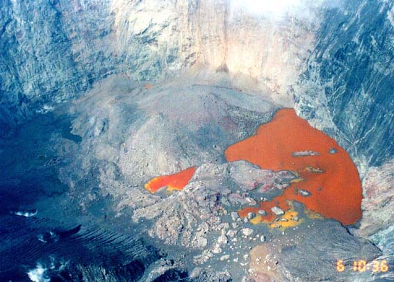
Dr. Osamu Oshima, University of Tokyo, who inspected the summit crater from a helicopter of a TV company on 20 August, first after the 18 Aug. eruption, reported three small cones with open pits inside the summit crater. Mud flow from the crater pits into the crater floor was observed. He observed some step faults cutting new deposits and believed still continuation of subsidence of the crater floor.
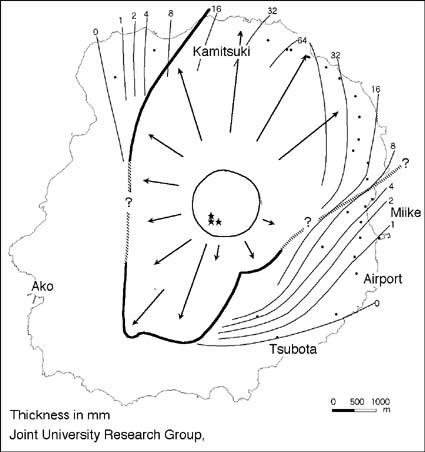
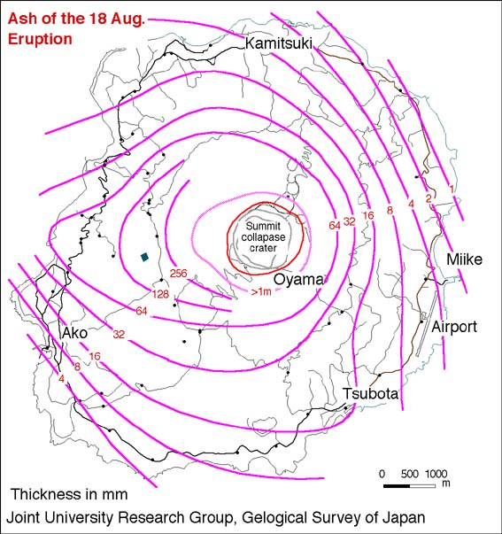
Distribution of ash of the 18 August eruption
Distribution of ballistics of the 18 August eruption
(08/19/00)
Relatively large eruption occurred on the 18 August afternoon. Dark ash cloud rose higher than 8 km from the crater. The eruption began around 5 p.m. and declined before 7 p.m. Abundant ash fell mainly in the northwestern part of the volcano island; as thick as 15 cm about 3 km away from the crater. Cinders as large as 5 cm fell over the airport which locates in the southeastern part of the island, breaking windows of automobiles.
 Yomiuri
Shinbun
Yomiuri
Shinbun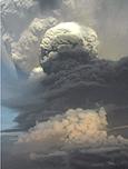 Nikkei
Shinbun
Nikkei
Shinbun Asashi
Shinbun
Asashi
ShinbunAt Miyakejima, phreatic eruption had occurred intermittently since 10 August, following the formation of a large collapsed crater (caldera) at the summit. The scale of the caldera was 1.4 km across and 450 m deep in the early August (see the photos listed below). The depression had continued since 8 July, being associated by repeating events of earthquake swarms and tilt change that had indicated sudden inflation and continuous deflation of the summit. GPS survey at the four sites surrounding the volcano had indicated continuous deflation of the summit. Even in the phreatic eruption stage that stated on 10 August, such geophysical phenomena had still continued.
The amount of eruption products before 10 August was around 2 million cubic meters, contrasting to the volume inside newly-formed caldera (0.35 cubic kilometers). The eruption on 10 August rose the eruption dark eruption cloud about 3 km and white cloud reached around 8 km according to the commercial airline pilot. In this time, white cloud reached more than 10 km. Evident juvenile materials had not been found in the eruption products. The products of the August 18 eruption are being analyzed. The ash seems to be very fine material typical of phreatic eruption.
Photos of collapsed caldera on 4 and 5 August
Photos of the 10 August eruptions
Photos of the 14 August eruptions
(07/23/00)
Tilt-meters installed by National Research Institute for Earth
Science and Disaster Prevention, on the middle flanks of the volcano,
surrounding the summit, had indicated repeated cycles of continuous
deflation of the summit with sudden inflation, roughly every 12
hours, since the 8 July summit collapse event. Before the sudden
inflation, the number of earthquakes including felt quakes increased
severely, according to JMA and ERI. The sudden inflation triggered
long-period earthquakes. These earthquakes occurred less than 2 km
deep just below the summit.
Phreatic eruption started around 4 a.m., 14 July, just after a
relatively large earthquake offshore of the volcano. Volcanic ash
covered thickly in the north to eastern parts of this volcanic
island. The eruption stopped around 1 p.m. of 15 July. On the late
afternoon of 14 July, a mass media (ANN) took the video of the
crater, which showed that the collapsed crater of the 8 July event
was enlarged and deepened, approximately 1 km across and 400 m deep.
This also showed small-scale phreatic eruptions with cock's tail jets
from a pit-crater (about 100 m across) on the bottom of the collapsed
crater.
Scientists of Earthquake Research Institute (U-Tokyo), Geological
Survey of Japan, and Nihon University started sedimentological
research of volcanic ash of this eruption on the 14 July morning. The
volume of volcanic products during 14-15 July eruptions was estimated
as small as less than 10 million cubic meters; probably around 10
million cubic meters including cinders near the crater. Eruption
products (reddish ash and cinders) of the 8 April eruption was
estimated as small as less than one million cubic meters. On the
other hand, the volumes of collapse were about 50 million cubic
meters for the 8 July event, according to Geographycal Survey
Institute, and roughly 200 million for the 14-15 events.
The summit area was surveyed by scientists on 19 and 20 July.
PHOTOS
Photos of phreatic eruptions and ash
deposition, taken on 14 July.
Photos of a summit collapse (2), taken
on 20 July.
EQ's
Earthquakes in
Miyakejima, ERI, U-Tokyo.
Earthquakes
around Miyakejima, ERI, U-Tokyo.
Animation
showing movement of earthquake swarms, ERI, U-Tokyo (sorry!
partly in Japanese)
(07/11/00)
National Coordination for Volcanic Eruption Prediction (Prof. Ida)
issued the following comments:
Earthquakes under the summit had been observed since July 7. The
activity had been elevated on July 8, and the amplitudes of volcanic
tremor events had increased around noon of that day. Thought ground
deformation monitoring had indicated a continuous deflation of the
volcano since the end of June, the tendency was accelerated that day.
At 18:41 an eruption cloud rose from the summit. The cloud reached
about 800 m and disappeared 10 minutes after the finding.
Based on the field inspection on the following day, a large collapse
crater, about 1 km across and about 200 m deep, was found on the
summit. Ash issued from the crater was very small in volume, compared
with the volume of depression, and no juvenile material was
found.
As a conclusion, this time summit-collapse event can be understood as
a caldera-floor collapse into a underground large space that was
formed being related to the migration of magma intruded in the
earliest stage of the event since 26 June.
As earthquakes under the summit and ground deformation have still
continued, collapse events that issue eruption clouds and cinders may
occur repeatedly. Attention to the summit activity is needed for a
while, but events affecting on the volcano flanks may not take
place.
Photos of a summit collapse, taken by S.
Nakada on the 9 July morning.
(06/30/00)
Izu-subcommittee in National Committee for Volcanic Eruption
Prediction (chaired by Prof. Hidefumi Watanabe, ERI, U-Tokyo) had
analyzed and evaluated monitoring data provided by national
institutes, Tokyo metropolitan government, universities and so on
since 26 June, and issued comments on the volcanic activity
repeatedly. The comment issued on the 29 June evening was as follows.
In Miyakejima, crustal deformation since the 26 June evening had
declined by the afternoon of 29 June, based on titlmeter and GPS
survey data. It was considered that magma supply into off the W coast
and widening by magma intrusion were coming to an end. In this
reason, there was little possibility of eruption affecting both land
and sea areas. However, seismic activity probably continues in a high
level for a short while.
Receiving this comment, local people who are living in S and W parts
of the island and had been requested by the local government to
evacuate into the N part on 26 June evening, were permitted to return
their home on the 29 June night.
Ground deformation of the present activity had been monitored by four
GPS's installed by Geographical Survey Institute. As the seismic
activity proceeded, the GPS data clearly caught the changes
associated with magma's movement.
(GSP
data, with Japanese captions). According to the Maritime Safety
Agency, the sea water taken from the discolored sea surface by their
sea-robot, MANBOU, on the 27 June afternoon, contained 1.3 mg/l of
Fe, Al and Si. The ratio of three elements (37, 56, 7 %,
respectively) is of magmatic fluid. Happening of an eruption at sea
bottom on the 27 June morning is still under discussion.
Joint University Research Group finishes deploying observation
equipment at many points throughout the island by 30 June in order to
detect the magma's behavior after the intrusion event, including GPS,
thermometer, broadband seismometer, proton-magnetometer, and absolute
gravity-meter.
(06/29/00)
Seismic swarm started in the evening of 26 June, being associated
with changes of tiltmeters that National Research Institute for Earth
Science and Disaster Prevention installed in the island. Volcanic
Advisory was issued by JMA at 19:30 of 26 June, stating that
earthquake activity increased since around 18:30, and the activity
had continued as of 19:30. Immediately following this, Volcanic Alert
was issued at19:33, announcing a high possibility of eruption at
Miyakejima.
The numbers of earthquakes and felt quakes increased with time, and
were peaked once in the mid-night. The number counted at observation
site A (SW of the summit) by JMA reached about 400 times an hour
(hourly
number of earthquakes). Earthquakes occurred first near the
summit, and the hypocenters migrated westward, and furthermore
outside the volcano island
(earthquake
distribution).
In the morning, 27 June, a fishing boat found
discolored
area on the sea surface near the western coast. The location was
just above the earthquake swarm. The discoloring had disappeared by
the noon of 27 June. However, it is not clear whether true eruption
(magma eruption) occurred on the sea bottom or not.
Although the seismicity had once declined by the morning of 27 June,
it increased again higher than the peak in the previous night. The
seismic activity had continued as of 29 June.
Miyakejima had experienced eruption every 22 years, including a few
missing eruption events. The latest eruption occurred in 1983. The
period between this time and 1983 is shorter than the number. In
1983, the village of Ako, W to SW part of the island, was covered
partly by basalt lava flows that were issued from fissures extending
to SW from the central part of the island. Swarms of earthquakes of
this time extended in the WNW direction from the summit, just north
of the eruption site of the 1983. On 28 June, scientists of
Geological Survey of Japan and universities inspected the surface
along roads in the W part of the island, and found many cracks and a
graben structure developed at Ako. It is likely that dike of magma
passed under the village.
Probably, this time event can be understood as an intrusive event
without magmatic surface manifestation.
For more details, go to
Miyakejima
by Taketo Shimano's site, VRC, ERI, U-Tokyo.
For seismic activity, look at
distribution
of earthquakes determined by ERI, U. Tokyo.
[Background]
Miyakejima locates about 180 km south of Tokyo, on the volcanic chain
of Izu-Ogasawara (or -Marian). Miyakejima is a volcanic island of
about 8 km across. Including the body under the sea level, the base
of the volcano has the diameter of about 13 km and the height is
about 1,000 m. It is a stratovolcano, consisting largely of basaltic
rocks. The summit area is characterized by double calderas, 3.5 and
1.5 km across, in which a scoria cone of Oyama locates. Near the
coastal line, there are many craters formed by phreatomagmatic
eruptions.
During these 500 years, twelve eruptions occurred having quiescent
period ranging from 21 to 69 years. The volume of each eruption
ranges from 20 to 30 million cubic meters. Steaming has been observed
at the summit cone. In the 20-th century, eruptions occurred in 1940,
1962, and 1983. The precursory seismic activity was generally short;
less than 6 hours. That of the 1983 eruption was as short as 1 hour
and half. The eruptive activity is characterized by the phenomenon in
which seismic activity after eruption continues in an area much far
from the eruption site for relatively long time.
Volcanic activity in Miyakejima has been monitored by Tokyo
Metropolitan Government-JMA-University of Tokyo (seismic
observation), National Institute for Earth Science and Disaster
Prevention (tiltmeter observation), Geographical Survey Institute
(GPS observation), and universities (GPS and electromagnetic
observations). Leveling survey by Tokyo Metropolitan Government and
GPS survey by universities that were repeated every year had clearly
caught the inflation of the island with the pressure source in the S
part of the island.
Information contacts: Hedifumi Watanabe, VRC, Earthquake
Research Insitute, University of Tokyo (watanabe@eri.u-tokyo.ac.jp);
Masayuki Kikuchi, Earthquake Information Center, ERI, U-Tokyo
(kikuchi@eri.u-tokyo.ac.jp); Taketo Shimano, VRC-ERI, U-Tokyo
(shimano@eri.u-tokyo.ac.jp); Volcano Research Center, ERI, U-Tokyo
(nakada@eri.u-tokyo.ac.jp); Makoto Murakami, Geograhical Survey
Institute (mccopy@gsi-mc.go.jp); Yoshimitsu Okada, National Institute
for Earth Science and Disaster Prevention (okada@geo.bosai.go.jp) ,
Yoshio Ueda, Maritime Safety Agency (ueda@cue.jhd.go.jp)