Website launched: 11/05/2017
Last updated: 15/05/2017
A warning was issued for the Iowyama volcano crater, by JMA (Japan Meteorological Agency) on 9th May 2017.
We are updating the report gained from the on-site survey.
15/05/2017
On the fumarolic activity at and near the Iowyama crater of Kirishima volcano
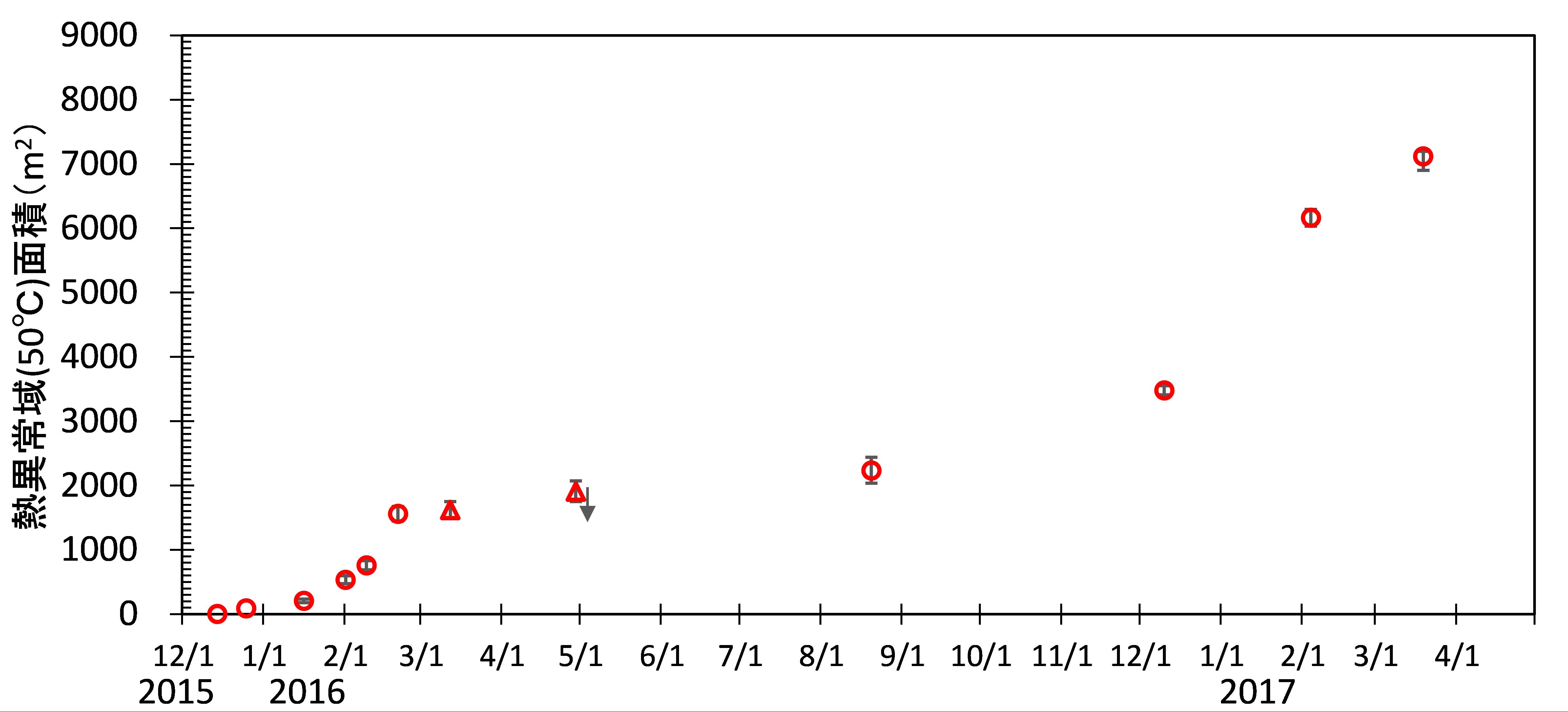
On the south side of Kirishimayama Iowyama crater, expansions of thermal anomalies such as fumarolic holes and hot water jetting pools have been recognized around March 2017. The temporal and spatial distribution of those area are considered important for considering the further transition of the volcanic activity at Iowyama. Therefore, it will be reporting as follows. In addition, a small eruption from the Fumarolic hole A (reported to the Volcano Eruption Prediction Committee on May 11), is estimated to have happened around 11:30 AM on April 26 from the re-analysis of the Japan Meteorological Agency’s real-time camera images.
1. Expansion of thermal anomaly area around the Iowyama crater
As reported in the 137th Volcanic Eruptions Prediction Liaison Meeting (Part 2 of 4 Kirishimayama, p. 77), a thermal anomaly are (Funesaki et al., 2017) was found in the southern rim and outer-slope of the Iowyama crater. The University of Tokyo Earthquake Research Institute etc.* inspected thermal anomalies on March 19, 2017 and confirmed that the thermal anomaly zone was expanding continuously (Fig. 1).
2. Ground surface deformation in the Iowyama fumarolic area
Figure 2 shows the thermal anomaly zones (observed on March 19, 2017) within the Iowyama fumarolic area and the location of fumarolic holes and hot water jetting pools. Based on the Ebino Plate Nature Conservation Council (1987), Funasaki et al. (2017), etc, the yellow coloration zones shown in FIG. 2 are places where the fumarolic activity is strong during May 5 to 10, 2017 (fumarolic zones). In addition, a circular to square holes with a diameter of 10 cm or more are formed which strongly gushing are called fumarolic holes.
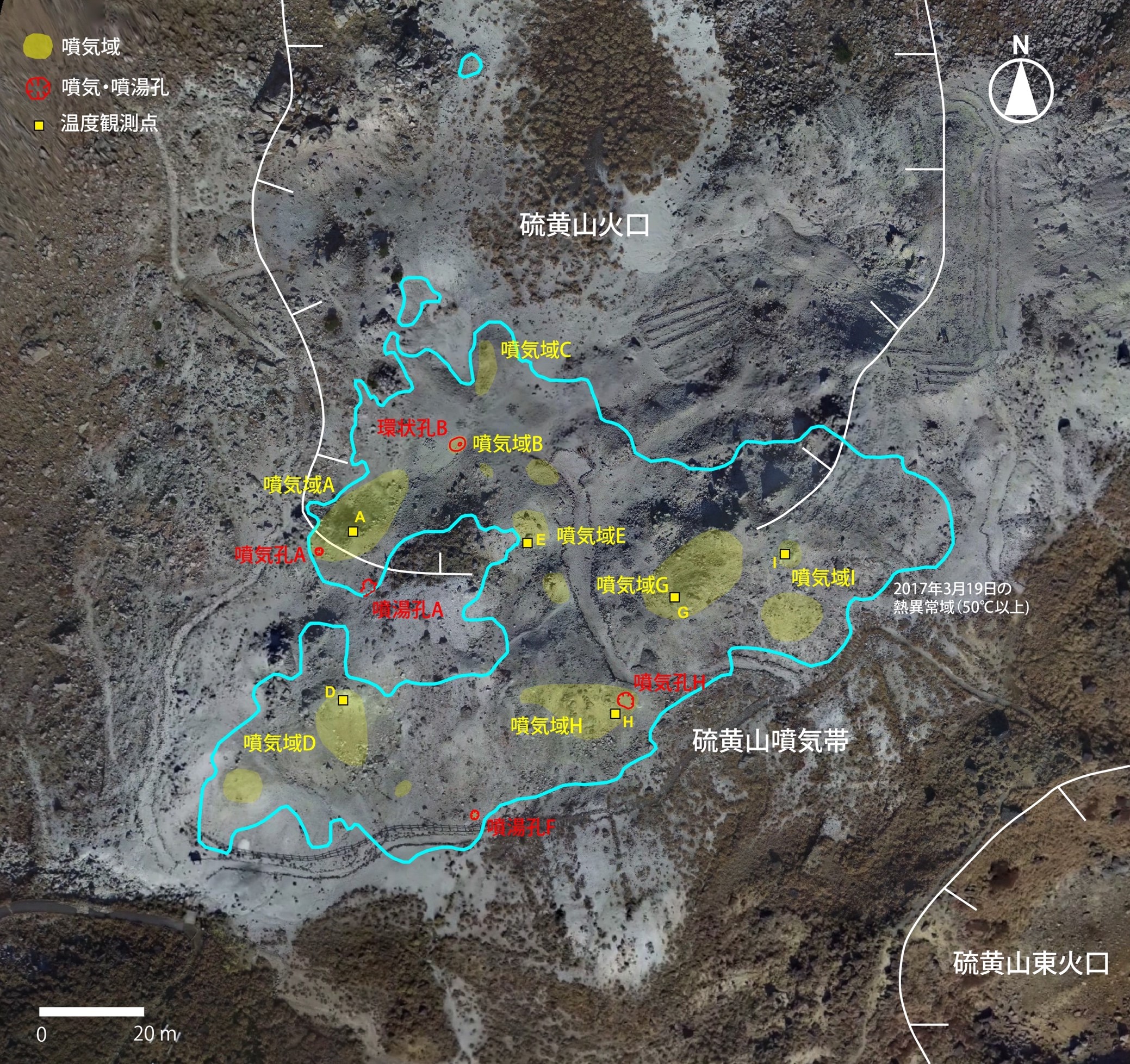
(1) Fumarolic hole A
On March 19, 2017, two fumarolic zones (2 m × 1 m, 1 m × 0.5 m) were found including Fumarolic hole A at the southern edge of the thermal anomaly area.
From there, a hot mud water (92.2 ° C.) was boiling. At this point, the hot water jetting pools of two has become into one on April 22. On May 7, expanded to 4 m × 3 m and on 10th, another hole was formed and it became a composite pool of 5 m ×3 m (Fig. 3). Since the Fumarolic hole A was not confirmed on February 4, it is considered to have formed between February 4 and March 19.
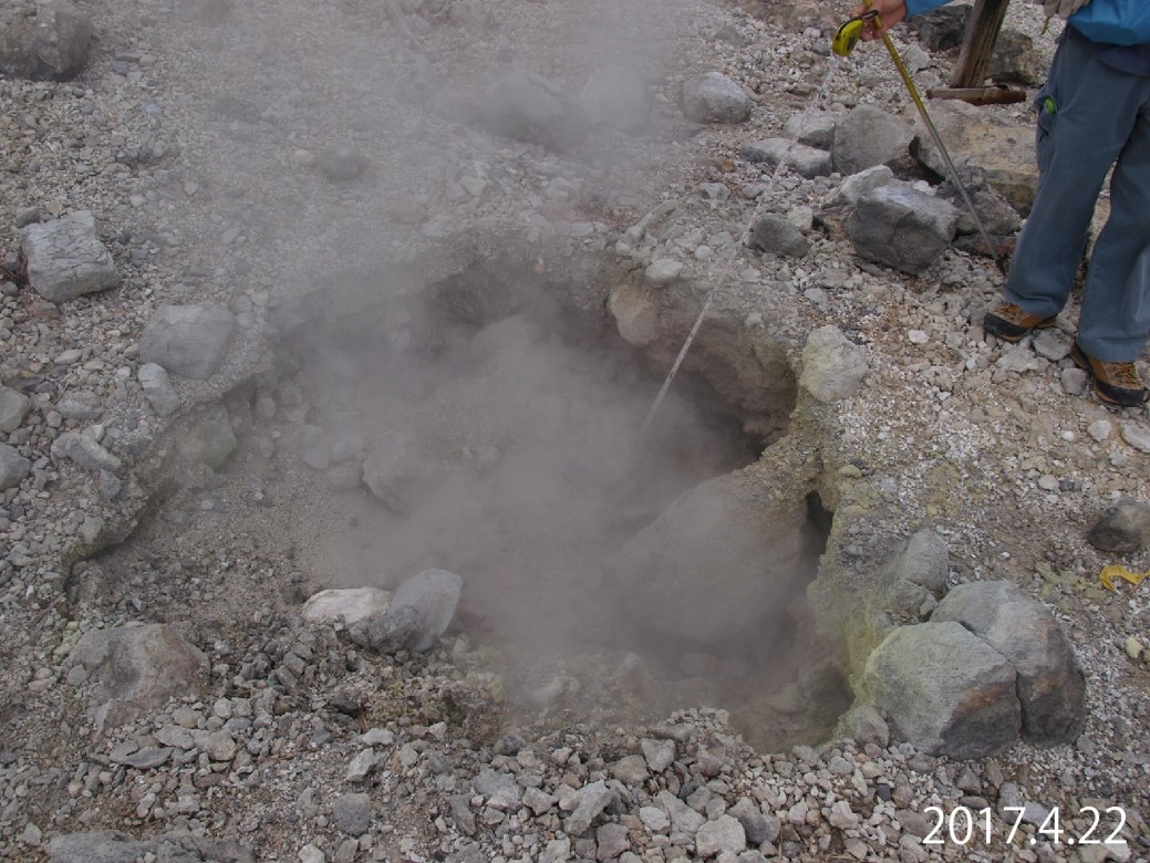
(2) Fumarolic hole F
On 22nd March, Fumarolic hole F of approximately 1 m in diameter was found by the Japan Meteorological Agency (2017) at the south side within the middle of the Fumarolic zone D and the Fumarolic zone H (Fig. 4). On April 22, the Fumarolic hole F expanded to about 1.8 m in diameter. Since the Fumarolic hole F was not seen on March 19, it is thought to have formed between March 19 and March 22.
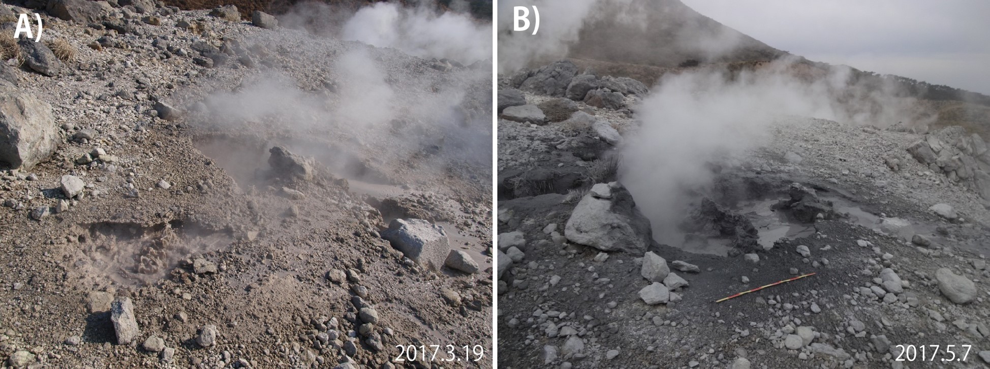
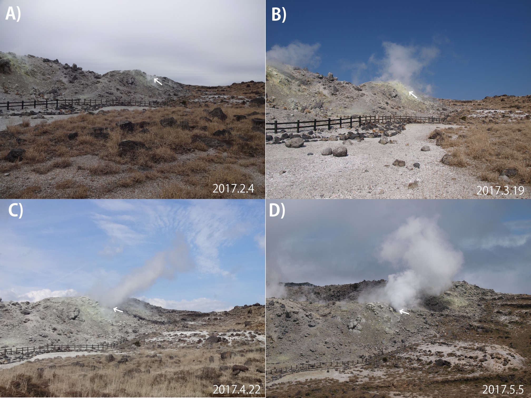
(3) Fumarole H
On April 22, 2017, the Fumarolic hole H with a diameter of about 1.5 m was found. A strong fume exited with roar from there (Fig. 5). By photograph comparison, it was confirmed that a mass of rock of about 1 m in diameter was newly deposited around the Fumarolic hole H. On April 22, we also confirmed the deposition of mud around this fumarolic hole (Fig. 6B). Therefore, it is considered that at the time of forming the fumarole H, rock fragments on the ground surface were blown off and deposited near on the surroundings, mud mixed hot water blew out. Furthermore, on May 5, it was recognized that the Fumarolic hole H was enlarged and that gravels of several centimeters in size were deposited around the hole (Fig. 6C). Fumarole H is thought to be still expanding while releasing gravel.
Arrows indicated the Fumarolic hole H. A) February 4, 2017, B March 19, 2017, C) April 22, 2017, D) May 5, 2017
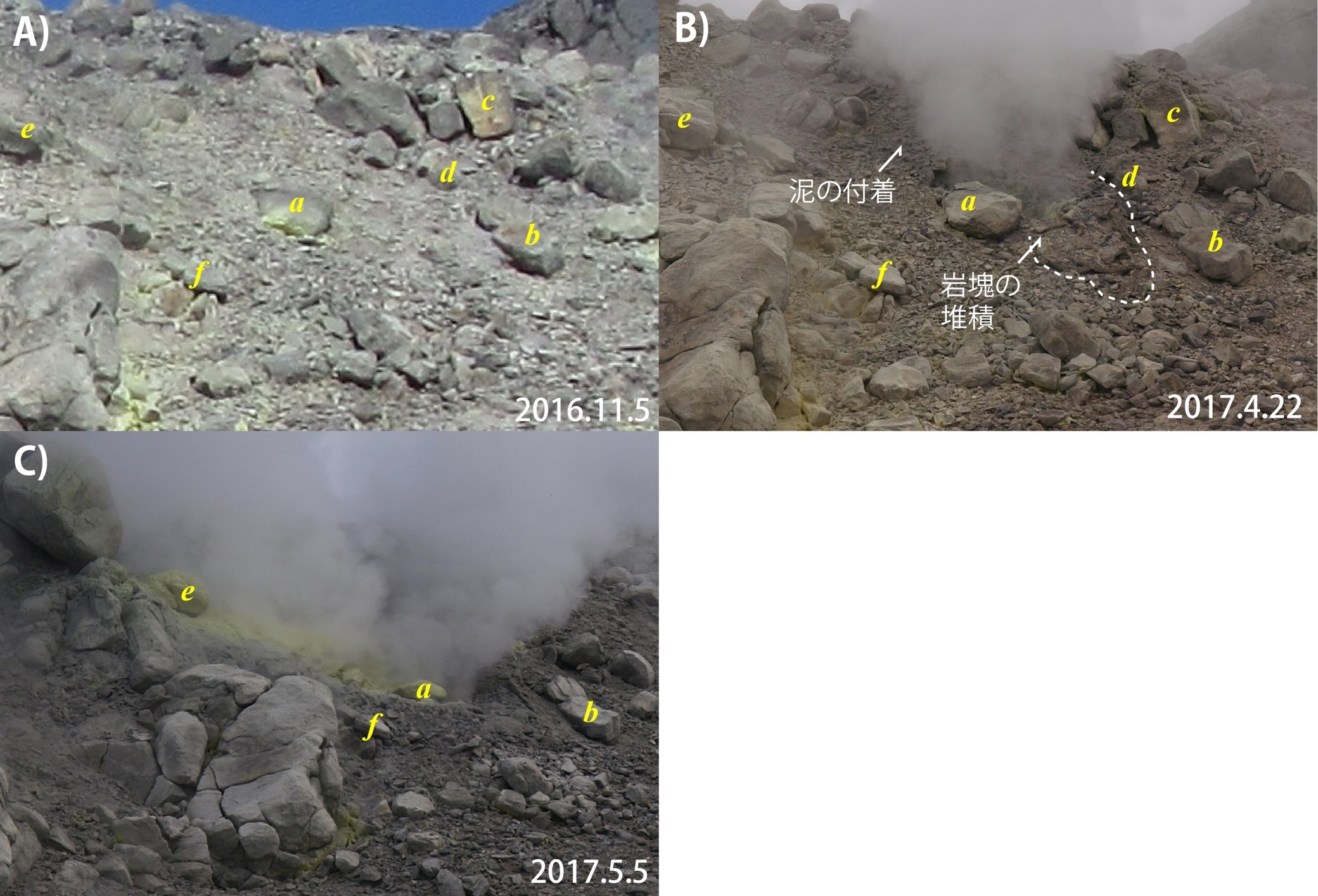
A) Before the formation of the Fumarolic hole H (Nov. 15, 2016). B) The hole of 1.5 m wide was formed (April 22, 2017). C) The hole H expanded (May 5, 2017).
(4) Fumarole hole A
The fumarole A was formed at the southwest end of the fumarolic zone A and released sediment and volcanic ash as it formed (small eruption). In the previous report, it was assumed that it was formed between April 28 and May 5 based on hearings, but from the footage of the Kirishimayama (Mt. Iowyama) camera of the JMA, it is estimated that this small eruption occurred on April 26.
That is, according to the Iowyama South camera image, strong fumes from the Fumarolic area A could not be seen until the morning of April 26. However, the image of 26th morning 11:29 showed the appearance of light gray white (lightly discolored) phreatic smoke from near Fumarolic zone A (Fig. 7). Also, lightly colored white fumes were seen at 10:20 am and 11:07 am. Fumarolic cloud (steam) around 10:20 am – 11:30 am was flowing southwest, which coincides with the distribution of the volcanic ash adherence zone reported earlier. In the vicinity of the Fumarole hole A, volcanic ash spreads also northeast, so it is estimated that the thermal cloud was spreading to the northeast at around 11:29 am and volcanic ash was released at that time.
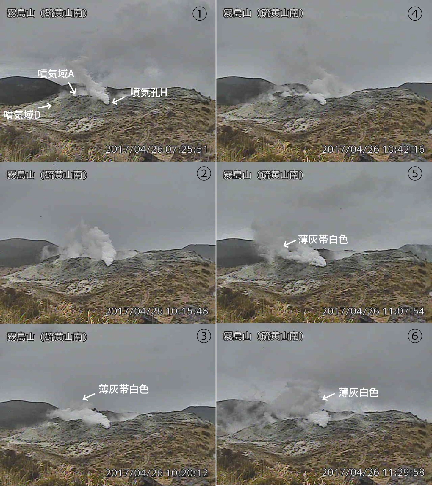
(http://www.data.jma.go.jp/svd/volcam/data/volc_img.php)
(5) Annular cracked zone B
In addition to the occurrence of the above-mentioned fumarolic holes and hot water jetting pools, annular cracked zone with a maximum diameter of 2 m or more were formed near the Fumarolic zone B on May 7 (Annular cracked zone B). At the center of the area with annular cracks in B, a subsidence of about 10 to 20 cm in depth occurred on May 7, after which the subsidence further advanced.
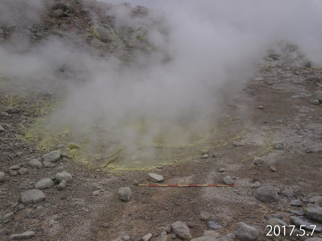
The maximum diameter the annual cracked zone is more than 2 m, and many fumaloic jetting occurred along the cracks (May 7, 2017)
(Volcano Research Center: Setsuya Nakada)
10/05/2017
Movie of the Iowyama crater, Kirishima Volcano on 10th May 2017. (Click the image to watch movie)
(Movie taken by Setsuya Nakada)
11/05/2017
A small eruption at the Iowyama crater, Kirishima Volcano (Kyushu)
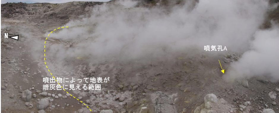
On the south side of the Iowyama crater, volcanic activity has increased with 2 additional fumaroles found in March 2017, and one of roaring sound in April 2017. ERI and Kirishima Nature Guide Club etc * conducted a field survey on May 5-10 and confirmed a new fumarole accompanied by sediment ejecta (volcanic ash) at the southwestern edge of the Iowyama crater
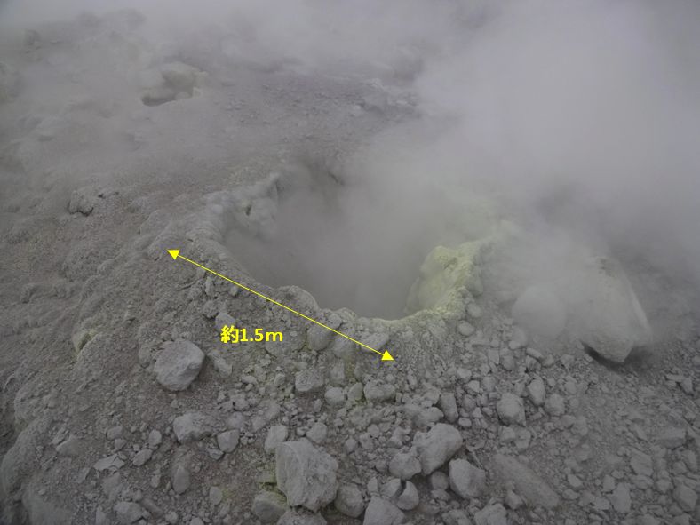
1. sediment ejection at the southwestern edge of the Iowyama crater
A newly confirmed fumarole (hereinafter Fumarole A) is located on the southwest edge of the Iowyama crater, where fumarolic activity has continued since December 2015. The fumarole A was quadrangle with 1.5m sides and >1 m depth (Fig. 3), from which strong fumarolic gas was emitted. This fumarole did not exist on April 22, and it appeared probably between April 28th and May 5th from the local people’s witnesses.
· Sediment ejecta was observed around fumarole A, and are distributed northeast and southwest from the fumarole. The surface covered with the ejecta is dark gray (Fig. 1, 2).
· In the southwest direction, the ground surface is grayish white due to adhesion of fine volcanic ash; gray white fine ash was observed on the green leaves and in the depressions on rocks. This can be traced up to 200m from Fumarole A. (Fig. 1).
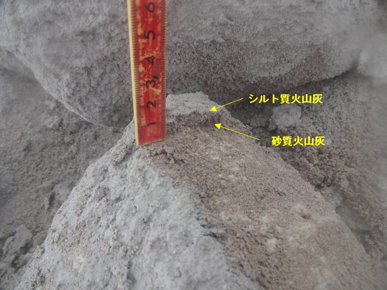
· The ejecta consists of two layers, the bottom is sandy volcanic ash, and the top is fine (silty) volcanic ash (Figure 4)
· The amounts of ejecta collected from two places near Fumarole A were 3.8 kg / m 2 and 3.4 kg / m 2, respectively (Fig. 1). Assuming that the ejected material covers the dark gray discoloration area around Fumarole A with the equivalent thickness (average of two values), the amount of ejected material is calculated as about 1 ton.
The amount of ejecta is as same as of the volume deficiency estimated from the size of the hole. The sediment accumulation relationship shows that the fumarolic hole opened first, then splashing of hot water containing mud followed.
Fine volcanic ash distributed southwest is thought to have been caused by the diffusion of mud-containing splashed hot water by strong wind. This phenomenon is presumed to be a small eruption caused by the outburst of a shallow steam pocket which was pressurized by heat from the depth.
(* figures are by Yasuhisa Tajima)

Small black squares are observation points. Numerical value: sediment mass (kg / m 2), +: ash present, -: ash slightly observed.
The background map is Geographical Survey Institute Map (Electronic GSI WEB)..The prefectural road No. 1 runs north to south on the left.