

Website launched: 2023/02/08 15:00
Last Updated:2023/02/10 10:00
2023/02/10 Questions and Answer are added on the bottom of this page.
Strong ground motion of the February 6, 2023 earthquake in Southern Turkey
February 8, 2023
Associate.Prof. Hiroe Miyake, Division of Disaster Mitigation Science
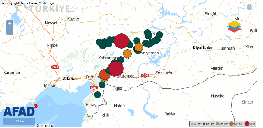
An earthquake with M7.8 occurred along the East Anatolian Fault Zone in Southern Turkey occurred at 4:17 local time (10:17 in Japan Standard Time) on February 6, 2023. After active aftershock seismicity activity including M6.7, about 9 hours later on February 6, at 13:24 local time (19:24 in Japan Standard Time), another M7.5 earthquake occurred near another fault located at the north away.
The magnitude and depth of the earthquakes show variations among research organizations.
M7.8 earthquake
USGS Mw7.8 depth 17.9 km
Global CMT Mw7.8 depth 14.9 km (with non-double components)
AFAD Mw7.7 depth 8.6 km
M7.5 earthquake
USGS Mw7.5 depth 10.0 km (with non-double components)
Global CMT Mw7.7d depth 12.0 km (with non-double components) AFAD Mw7.6 depth 7.0 km
Recent inland earthquakes with magnitude around 7.8 are the 2008 Wechuan, China, earthquake (Mw7.9), the 2002 Denali, Alaska, earthquake (Mw7.9), and the 2001 Kunlun, China, earthquake (Mw7.8). However, there has not been a series of earthquakes of approximately the same magnitude as this time.
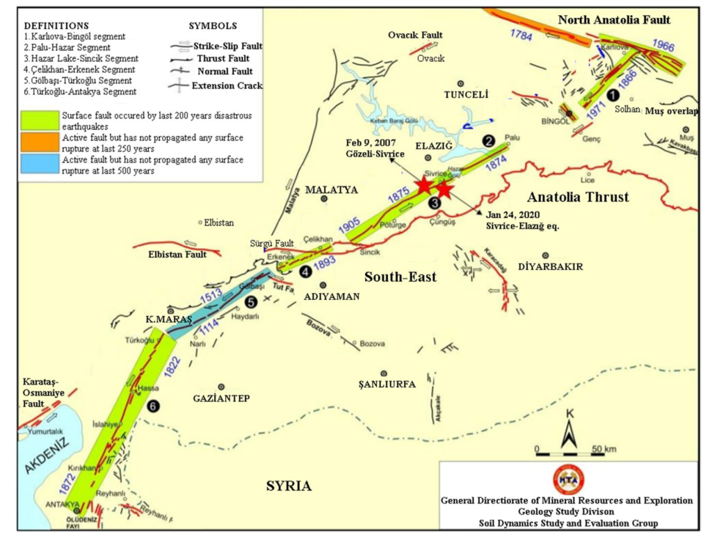
The M7.8 earthquake in Turkey occurred mainly northeast of the epicenter along the earthquake gap (light blue area in Fig. 2) that had been pointed out since the Great Earthquake of 1513 along the East Anatolian Fault Zone. The East Anatolian Fault Zone is a left-lateral strike-slip fault bounded by the Anatolian Microplate and the Arabian Plate. Judging from the USGS epicenter location and past active fault maps (published by MTA, Turkey, Emre et al., 2013), the rupture started on a northwest-dipping normal fault (Narli fault) and transferred to the East Anatolian fault. After that, it is believed that the main rupture occurred in the northeast direction. On the other hand, the M7.5 earthquake is thought to have been ruptured mainly by the Cardak Fault (formerly known as the Elbistan Fault), an east-west left-lateral strike-slip fault derived from the East Anatolian Fault. Since the epicenter is located near the center of the fault, the rupture is believed to have propagated in both directions. Historical earthquakes (e.g., Ambraseys, 2009) have been confirmed in the vicinity.
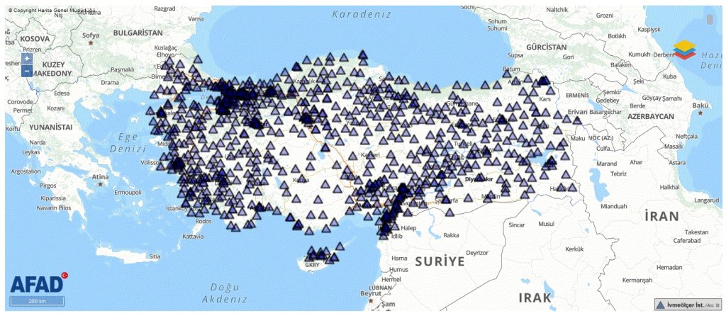
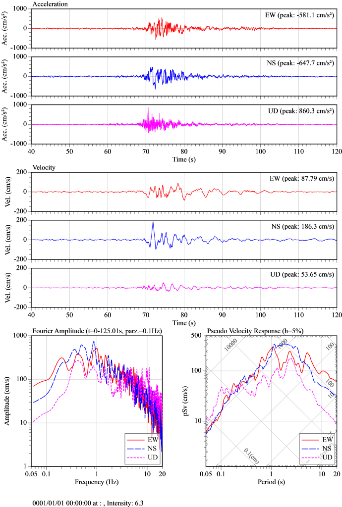
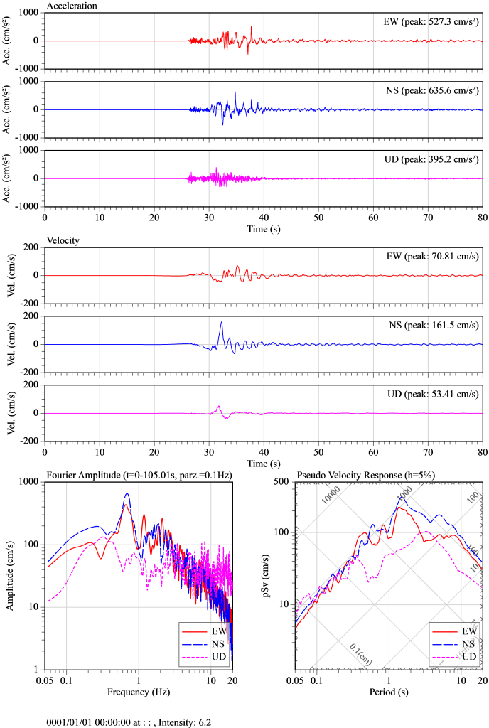
In preparation for such a situation, Turkey has developed strong motion observations throughout the country (Fig. 3), and AFAD in Ankara has released strong motion records. For both the M7.8 and M7.5 earthquakes, strong ground motions with large acceleration, velocity, and displacement were observed over a wide area along the fault, with a period of 1 to 2 seconds, believed to be caused by fault slip. A pulse-like ground motion is also confirmed. At present, the maximum acceleration is about 880 cm/s2, the maximum velocity is about 187 cm/s (according to the filter by AFAD), and the maximum velocity response is about 400 cm/s. Figs. 4 and 5 show the stations with maximum velocities for the M7.8 and M7.5 earthquakes, respectively.
The ground motions of the M7.8 and M7.5 earthquakes is roughly shows the expected acceleration levels, but are characterized by large ground velocities that are related to damages. Due to the magnitude of the earthquake, it is thought that a fairly wide area was suffered by strong shaking. The recording of the strong motion records was discontinued at some stations, and the AFAD is currently investigating, indicating that an update of the information is awaited. Surveys at strong motion stations in Hatay and Kahramammaras along the fault (Özmen, Yamanaka et al., 2017) are also useful to reference.
Questions (Elif Karaca, NASIL BİR EKONOMİ) and Answer (Associate Prof. Hiroe Miyake)
-Why did this latest earthquake in southeast Turkey cause so much
damage? Is this just because of the intensity, magnitude of the
earthquake or the lack of appropriate construction?
The scale of the earthquake was large that the shake became larger in wide area. Also, it was an inland earthquake, which means that the shaken area were land and not in the ocean.
In addition to those natural phenomena, the area had relatively large population and the structures were not very sturdy. Such damage was caused by complex combination of these factors.
-Japan is also a country of great earthquakes, but there has been much
less loss of life in recent years. How did Japan manage to cope with the
earthquake?
Japan, after world war two, has not experienced such magnitude of earthquake in an area with so densely populated area. In order to prepare for the coming earthquake disaster, infrastructure such as structures, railways, highways, water supply, electricity, and gas are continuously being maintained and re-evaluated.
-What would you recommend for Turkey to be less damaged in earthquakes,
what should be done?
I recommend that the structures be strengthened. It would also be useful to inspect structures, prioritizing places where no destructive earthquakes have occurred in recent years.
This time, an earthquake occurred in the East Anatolian fault zone, but in the North Anatolian fault zone, the area around Istanbul is said to be the next seismic gap.
It would be also effective to revitalize the awareness-raising activities that are already being carried out in Turkey. (For example, refer to the previous SATPRES Turkey figure:https://www.jst.go.jp/global/kadai/image/h2408_turkey/photo0_l.jpg)