Friday Seminar (17 March 2023) Julien Chaput (Univ. Texas El Paso)

Title:  Volcano imaging from distributed passive sources.

Abstract
A large portion of the world’s active volcanoes are glaciated, and the significant topographic gradients result in a large amount of distributed gravity and temperature driven icequake activity. These small impulsive events typically excite high frequencies (1-20 Hz), and their pervasive nature makes them ideal for Green’s function reconstructions through seismic interferometry and for statistical analysis using diffusion and radiative transfer arguments. We showcase our progress in developing an eventual “ground up” workflow and code base particularly well-suited to temporary nodal deployments that encompasses detection and databasing of icequakes, Bayesian coda cross-correlation for Green’s function reconstruction, envelope modeling via radiative transfer with concurrent event localization, and array-based scattering imaging for conduit system mapping (with Institut Langevin and UJF Grenoble). We show applications and ongoing work at Erebus volcano, Antarctica.

東京大学地震研究所技術職員採用説明会のご案内

東京大学地震研究所技術部では、技術開発室及び総合観測室においてそれぞれ1名ずつ、技術職員を新規採用予定です。 来年度末に学部または修士課程を卒業・修了予定の方や民間企業等に在職中の方で、地震研究所で技術職員として 勤務することに興味がある方を対象に、オンライン説明会及び現地説明会を実施いたしますので、是非、ご参加ください。

◆オンライン説明会開催日時:内容はいずれも同じ
2023年3月 4日(土)①10:00~10:30 ②10:40~11:10 ③12:50~13:20 ④13:30~14:00オンライン開催
2023年4月15日(土)①10:00~10:30 ②10:40~11:10 ③12:50~13:20 ④13:30~14:00オンライン開催

◆現地説明会開催日程:2023年5月 19日(金)10:00~12:00(9:45受付開始) 

◆参加人数:特になし
◆参加資格:就職・転職を検討している方で、東京大学地震研究所の技術職について興味がある方。学部生の参加も歓迎します。
◆申込締切:3月4日開催:3月3日(金)17:00まで 4月15日開催:4月14日(金)17:00まで 5月19日(金)開催:5月18日(木)17:00まで
◆開催概要:東京大学地震研究所技術部技術開発室・総合観測室紹介及び公募概要や業務内容の説明、先輩技術職員との対話など。

◆申込登録:次のいずれかにより事前にお申込ください。  
①関東甲信越地区国立大学法人等職員採用試験HP>説明会情報>関東甲信越地区国立大学法人等職員合同説明会  https://ssj.adm.u-tokyo.ac.jp/seminar/  
②マイナビ(東京大学地震研究所の採用情報掲載ページ)からの申し込みhttps://job.mynavi.jp/24/pc/search/corp270574/outline.html
③以下のFormsからの申し込み  https://forms.office.com/r/PbJX69kuth 

※現地説明会への参加申し込みは、②または③の方法によりお申込みください。
※説明会申込受付後、開催情報等をメールでお知らせします。


☆リクルート情報の詳細はこちらのページをご覧下さい。
東京大学地震研究所 https://www.eri.u-tokyo.ac.jp/recruitinfo/
マイナビ24(東京大学地震研究所)https://job.mynavi.jp/24/pc/search/corp270574/outline.html
東京大学職員採用情報 https://www.u-tokyo.ac.jp/recruit/info/index_j.html


お問合せ:
東京大学地震研究所庶務チーム(人事担当)
電子メール:jinji%eri.u-tokyo.ac.jp(%を@に置き換えてください。)
電話:03-5841-5668

Friday Seminar (24 February 2023) Danijel Schorlemmer (GFZ Potsdam)

Title: High-resolution exposure and sensor deployments: Chances for seismology and risk research


Abstract:

The substantial reduction of disaster risk and live losses, a major goal of the Sendai Framework by the United Nations Office for Disaster Risk Reduction (UNISDR) requires a clear understanding of the dynamics of the built environment and how it affects, in case of natural disasters, the life of communities, represented by local governments and individuals. Communities that participate in risk assessments increase their understanding of efficient risk mitigation measures. Our Global Dynamic Exposure model and its technical infrastructure build on the involvement of society in a crowd-sourced approach. Simultaneously, it helps educating communities in the risks they are facing and how they can prevent losses of lives.


We are in the process of creating super high-resolution data products for better assessment of seismic risk. Based on the plethora of open data and volunteer geographic information like OpenStreetMap, we have created a super high-resolution and dynamic exposure model that attempts to characterize probabilistically every building on Earth for better risk assessments. We are employing a crowd-sourced capturing of exposure indicators using OpenStreetMap (OSM), an ideal foundation with already more than 500 million building footprints (growing by ~150’000 per day), and information about school, hospital, and other critical facilities. With our OpenBuildingMap system, we are harvesting this dataset by processing every building in near-realtime. We are collecting exposure and vulnerability indicators from explicitly provided data (e.g. hospital locations), implicitly provided data (e.g. building shapes and positions), and semantically derived data, i.e. interpretation applying expert knowledge. The expert knowledge is needed to translate the simple building properties as captured by OpenStreetMap users into a probabilistic assessment of vulnerability and exposure indicators and subsequently into probabilistic building classifications as defined in the Building Taxonomy 2.0 developed by the Global Earthquake Model (GEM). With this approach, we increase the resolution of existing exposure models from aggregated exposure information to building-by-building vulnerability.


Simultaneously, we have started with dense acceleration-sensor deployments in the wider Tokyo area. We have explored the utility of the smartphone-type sensors built into small devices directly plugged to power outlets in the wall for the use by volunteers and companies. We deployed 10 devices to private people in the Zama region in 2021 and 50 devices in the larger Tokyo region in 2022 for about a half year each. Additionally, we have equipped the 48-story Tokyo Metropolitan government building in Shinjuku, Tokyo, with many devices on floors ranging from 1st to 44th, and one 6-story building of the Tokyo Narita International Airport with many devices on four floors. All devices have provided us with both three-component acceleration records and seismic intensities in the Japan Meteorological Agency (JMA) scale, which is familiar to non-professional Japanese people. The measured seismic intensities on different floors and within the same floor show a variety of values different to the reported JMA intensity for the wider area. Also, we have obtained human assessments of experienced seismic intensity.


We want to present our future plans for massive sensor deployments and their goals. We are planning to expand the experiment to more than 1000 households in the Tokyo area for better defining the needs of homeowners, tenants, or facility managers. Further plans include equipping neighboring buildings with sensors in order to estimate the ground-motion variability on small spatial scales to better understand the necessary measuring bandwidth for ground motions and intensities. A collaboration with ISC will show how the sensor data can be used for improving overall seismic networks in terms of location uncertainty and initial localization speed.


第1022回地震研究所談話会開催のお知らせ

下記のとおり地震研究所談話会を開催いたします。

ご登録いただいたアドレスへ、開催当日午前中にURL・PWDをお送りいたします。
なお、お知らせするzoomURLの二次配布はご遠慮ください。また、著作権の問題が
ありますので、配信される映像・音声の録画、録音を固く禁じます。

                   記

    日  時: 令和5年2月17日(金) 午後1時30分~ 

    開催方法: インターネット WEB会議

1. 13:30-13:45

演題:数値モデルとレーダー観測による噴煙柱の3次元再構築 【短期招聘研究員成果報告】

著者:○Magfira SYARIFUDDIN (State Agriculture Polytechnic of Kupang) 、鈴木雄治郎

要旨:We incorporate the velocity estimates from a weather radar observation into a three-dimensional (3D) numerical model to reconstruct the volcanic ash column of a VEI-2 eruption in Sinabung, Indonesia, on 19 February 2018.

2. 13:45-14:00

演題:小型磁気センサーを用いた磁場観測装置の開発状況の報告【所長裁量経費成果報告】

著者:○臼井嘉哉

要旨:小型磁気センサーであるMIセンサーを用いた地磁気観測装置の開発を行っている。本発表では開発の現在の進捗状況を報告する。

3. 14:00-14:15

演題:Detection and analysis of seismoacoustic wavefield of Popocatepetl volcano, Mexico

著者:○Gerardo MENDO-PEREZ、 Alejandra ARCINIEGA-CEBALLOS(UNAM, Mexico)、Robin MATOZA(UCSB, United States) 、Alejandro ROSADO-FUENTES (UNAM, Mexico)

要旨:We present the infrasound and seismic signals associated to the explosive activity of Popocatepetl volcano.

4.14:15-14:30

演題:ブロードバンド・バイブレーター震源を用いた超高分解能反射法地震探査による活断層の構造イメージングの可能性【所長裁量経費成果報告】

著者:○石山達也、中西利典(ふじのくにミュージアム)、加藤直子(日本大学)

要旨:「大規模伏在活断層の構造・活動性解明プロジェクト室」の一環で、駿河トラフ陸上延長部の伏在断層の構造的な特徴と完新世後期〜歴史時代の活動について、ボーリング調査・高分解能反射法地震探査などに基づき検討した結果を報告する。

5.14:30-14:45

演題:「地震記象が少ない時代の『やや大きい地震』総覧充実」プロジェクト室

【所長裁量経費成果報告】

著者:○石瀬素子・酒井慎一・中川茂樹、石辺岳男(地震予知総合研究振興会)、

室谷智子(国立科学博物館)

6.14:45-15:00

演題:2023年トルコ南部の地震:強震動

著者:〇三宅弘恵、山中浩明(東京工業大学)、近藤久雄(産業技術総合研究所)、Ozgur Tuna OZMEN(トルコ災害緊急事態対策庁)、Aysegul ASKAN(中東工科大学)、

Gulum TANIRCAN(ボアジチ大学カンデリ地震観測研究所)

○発表者

※時間は質問時間を含みます。

※既に継続参加をお申し出いただいている方は、当日zoomURLを自動送信いたします。

※談話会のお知らせが不要な方は下記までご連絡ください。

〒113-0032 東京都文京区弥生1-1-1 

東京大学地震研究所 共同利用担当

E-mail:k-kyodoriyo(at)eri.u-tokyo.ac.jp

※次回の談話会は令和5年3月17日(金) 午後1時30分~です。

Friday Seminar (17 February 2023) Bernd Schurr (GFZ Potsdam)

Squeezing and lifting – modes of long-term forearc deformation in the Northern Chile subduction zone

Bernd Schurr, GFZ German Research Centre for Geosciences

Subduction zone forearcs deform transiently and permanently due to the frictional coupling with the converging lower plate. Transient stresses are mostly the elastic response to the seismic cycle. Permanent deformation is evidenced by forearc topography, upper plate faulting and earthquakes; its relation to the megathrust seismic cycle is debated. Here we study upper plate seismicity in the northern Chile subduction zone as a proxy for forearc brittle deformation. We find that seismicity is distributed unevenly and a dramatic increase correlates both with a break in the morphology and tectonics of the Coastal Cordillera and the onset of a change in subduction obliqueness. Earthquakes in the South American crust under the sea and under the Coastal Cordillera show a remarkably homogenous north-south, i.e., trench-parallel, compressional stress field. Earthquake fault mechanisms are dominated by trench-perpendicular thrusts. Further inland, where the lower plate becomes uncoupled, the stress field is more varied with direction east-west to southeast-northwest (approx. convergence parallel) dominating. The stress-regime above the plate-coupling-zone, almost perpendicular to plate convergence direction, may be explained by a trench-parallel strain component from a change in subduction obliqueness due to the concave shape of the plate margin, which we demonstrate by investigating inter-plate earthquake slip vectors. From these, we derive a strain rate estimate and compare it to one derived from upper plate earthquakes. In the southern part of our study area, where convergence obliqueness is constant, upper plate seismicity is sparse, but Coastal Cordillera elevation and the uplift rate are higher than in the north. A new relocation of two megathrust earthquake aftershock sequences reveals a flat-ramp-flat structure that we interpret as underplating of a 3 km thick slice of eroded material and/or oceanic crust. This structure is also visible in the residual gravity field and in a tomographic model of the region. Our study demonstrates thus two very different mechanisms of forearc thickening active on two neighboring segments of a subduction zone.


2023年2月6日トルコ南部の地震

ウェブサイト立ち上げ:2023年2月8日

最終更新日:2023年2月10日16:00


その他のQ&Aをこのページの最後に掲載してあります。お問合せは orhp@eri.u-tokyo.ac.jp までおよせください。


2023年トルコ南部の地震 強震動

2023年2月8日版
災害科学系研究部門 三宅 弘恵 准教授

2023年2月6日現地時間4:17(日本時間10:17)にトルコ南部の東アナトリア断層沿いでM7.8の地震が発生した。その後、M6.7を含む活発な余震活動が続いた後、約9時間後の2月6日現地時間13:24(日本時間19:24)、M7.8の地震からやや離れた北側の別の断層付近でM7.5の地震が発生した。

Fig. 1. M7.8(下の赤丸)とM7.5(上の赤丸)の地震の震央(AFADの図面に加筆)

地震の規模と深さは、研究機関によって値が異なっている。
M7.8の地震
USGS →Mw7.8 深さ17.9 km
Global CMT→ Mw7.8 深さ14.9 km(非ダブルカップル成分が多い)
AFAD →Mw7.7 深さ 8.6 km
M7.5の地震
USGS→ Mw7.5 深さ10.0 km(非ダブルカップル成分が多い)
Global CMT→ Mw7.7 深さ12.0 km(非ダブルカップル成分が多い)
AFAD→ Mw7.6 深さ7.0 km

近年に内陸で発生したM7.8程度の地震は、2008年の中国・四川地震(Mw7.9)や、2002年の米国・アラスカのデナリ地震(Mw7.9)、2001年中国・崑崙地震(Mw7.8)などがある。しかし、今回のように、ほぼ同程度の地震規模の続発地震は発生していない。

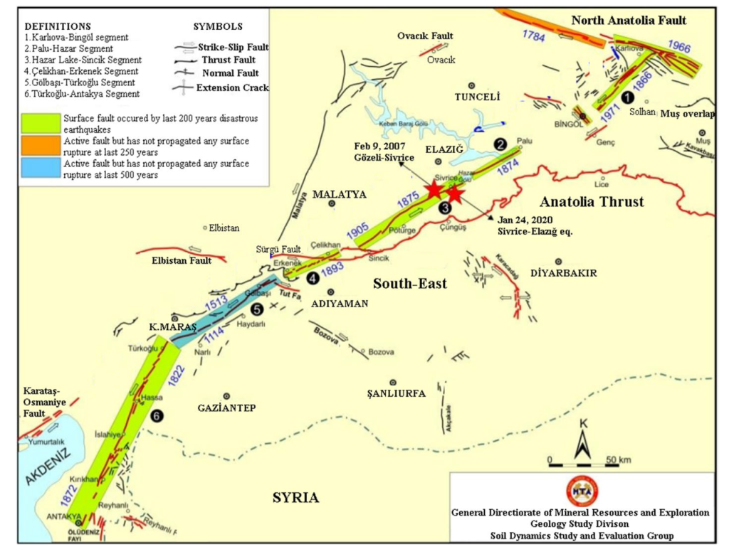
今回のトルコのM7.8の地震は、東アナトリア断層沿いにおいてかねてから1513年の大地震以降に指摘されていた地震の空白域(Fig. 2の水色部分)に沿って、震源から主に北東に向かって破壊した。東アナトリア断層はアナトリアマイクロプレートとアラビアプレートを境界とする左横ずれ断層である。USGSの震央位置と既往の活断層図(トルコMTA発行,Emre et al., 2013)から判断して、破壊の開始は北西傾斜の正断層(ナルリ断層)から始まり、東アナトリア断層に乗り換わった後、北東方向への主破壊が生じたとみられる。一方、M7.5の地震は、東アナトリア断層から派生した、東西方向の左横ずれ断層であるチャルダック断層(旧称:エルビスタン断層)が主に破壊したと考えられる。震央位置は同断層の中央付近に位置するため、双方向に破壊が伝播したとみられる。付近では、歴史地震(例えばAmbraseys, 2009)が確認されている。

Fig. 2. トルコMTAとKürçer et al. (2020) による東アナトリア断層の主要セグメントと歴史地震 (Sayın et al., 2021)。M7.8の地震は、主に水色の部分を破壊したと考えられる。

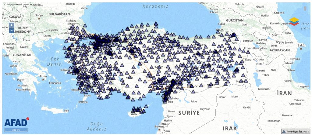
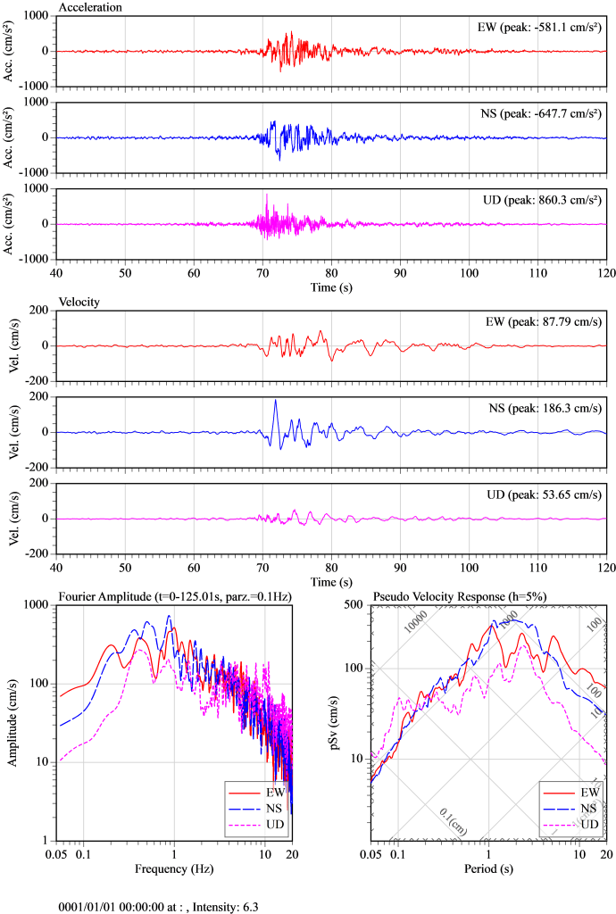
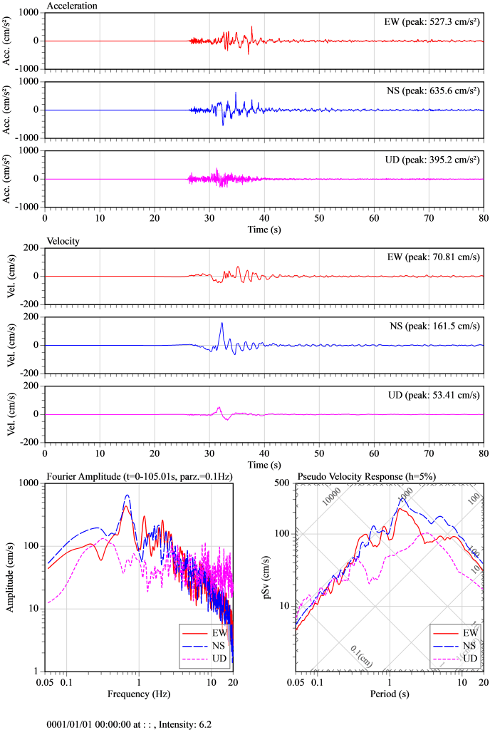
トルコでは、このような事態に備えて強震観測を全土で整備しており (Fig. 3)、アンカラのAFADから強震記録が公開されている。M7.8の地震もM7.5の地震も、加速度・速度・変位のいずれも大きな強震動が、断層に沿って広範囲で観測されており、断層のすべりが原因と思われる周期1~2秒程度のパルス的な波形も確認されている。現時点では最大加速度が880 cm/s2程度、最大速度が187cm/s程度(AFADのフィルターに拠る)、最大速度応答が400 cm/s程度である。M7.8とM7.5の地震のうち、最大速度がそれぞれ大きな観測点をFig. 4とFig. 5に示す。

今回の地震は、内陸で発生するM7.8やM7.5の大地震として、加速度としては概ね想定されるレベルであるが、被害に関係する速度が大きい特徴がある。地震規模が大きいため、相当広い範囲が強い揺れに見舞われたと考えられる。

なお、強震記録は収録が途中で断絶している観測点もあり、AFADが精査中であるため、情報の更新が待たれる。断層周辺のHatay県やKahramanmaras県の強震観測点における地盤調査(Özmen, Yamanaka et al., 2017)も参考になる。

Fig. 3. トルコの強震観測点分布(AFAD提供)
Fig. 4. M7.8の地震の強震動の例(Hatay県の3123観測点;建築研究所ViewWaveを使用)
Fig. 5. M7.5の地震の強震動の例(Kahramanmaras県の4612観測点;建築研究所ViewWaveを使用)

Q (Elif Karaca, NASIL BİR EKONOMİ) and A (三宅 弘恵 准教授/楠 浩一 教授)

Q:なぜこれほどの被害が出たのか? Mや震度が大きかったのか,建造物の強度不足だったのか?

(三宅)自然現象の原因としては,地震規模が大きく,そのため揺れが広範囲で大きくなった.しかも内陸の地震なので,揺れた場所のほとんどが海ではなく陸である.自然現象以外の原因として,それなりに人口がある地域で,かつ構造物がそれほど頑丈ではなかったため,これらの要素が複合的に組み合わさって,これほどの被害が生じたと考えられる.

(楠)地表面加速度が大きかったこと、つまり、いくつかの地点で兵庫県南部地震の際のJR鷹取、熊本地震の特の益城の記録にも匹敵していた可能性があります。そのため、中層に至るまでの建物に被害が広がっています。なお,建造物が強度不足かどうかは、設計図書等を精査しないとわかりません。ちなみに最新のトルコの耐震規定は、ユーロコードも参考にしており、最先端です。

Q:日本もまた地震国であるのに,最近の被害ははるかに少ないように思われる.日本では地震への対処をどうしているのか?

(三宅)戦後の日本は,これほどの地震規模の地震を人口密集地で経験していない.来たるべき地震災害に備えて,構造物,鉄道,高速道路,水道・電力・ガスなどのインフラの整備を継続的に行い,見直しを続けている.

(楠) 我が国の耐震規定は、大きな地震被害を被る度に適切に改正されてきました.従って,今日の設計基準は地震被害を抑えることにある程度貢献しています。問題は、既存建物です。改正建築基準法は既存建物には遡及されません。そのため、改正してもその効果が表れるのに結構時間がかかってしまいます。その教訓から、兵庫県南部地震以降、耐震改修促進法を制定し、既存建物の耐震診断・耐震補強を推進してきたことも大きな理由です。なお、トルコにも耐震診断・補強の手順はあります。

Q:トルコにおける地震被害軽減のため,何をすべきと考えるか?

(三宅)構造物を地震に対して強くすることが必要と考えられる.近年被害地震が起きていない場所を優先して,構造物を点検することも有用であろう.今回は,東アナトリア断層帯で地震が発生したが,北アナトリア断層帯では,次にイスタンブール周辺が地震の空白域と言われており,すでにトルコでは行われている啓発活動等の活性化も有効であろう
(例えば,下記の図面を参照,前回のSATPRESトルコの図面)
https://www.jst.go.jp/global/kadai/image/h2408_turkey/photo0_l.jpg

(楠)まずは建物の年代・設計法・地盤状況と被害の関係を調査し、同時に古い基準で設計された建物の耐震診断・補強を進めることだと思います.

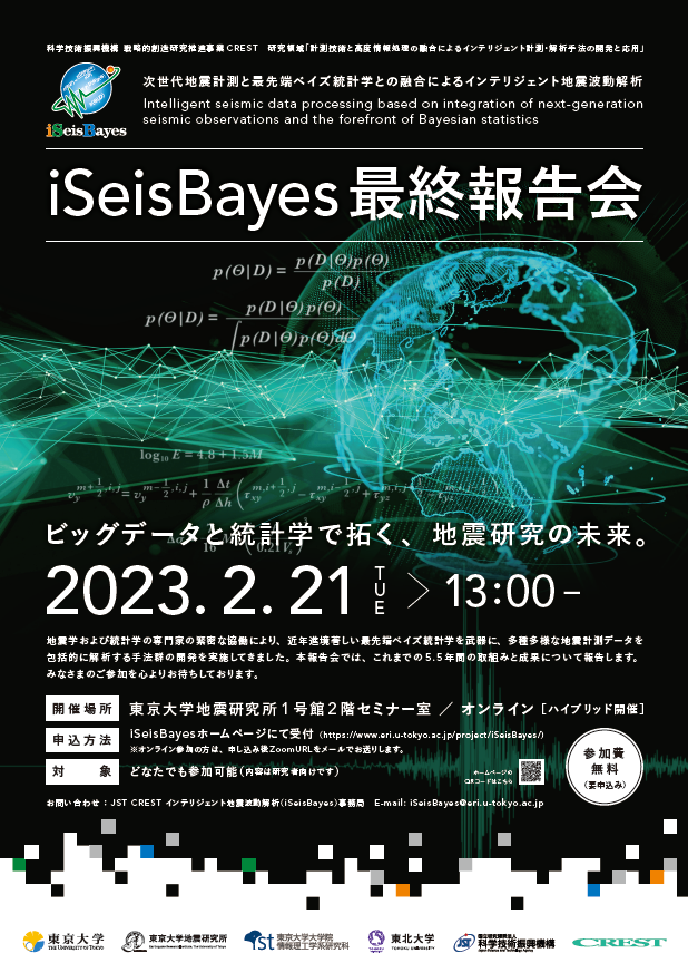
iSeisBayes最終成果報告会

【最終成果報告会】

日時:2023年 2月21日(火)13:00~18:00

開催場所:東京大学地震研究所 1号館2階 セミナー室およびオンライン(Zoom)

参加費:無料

対象:どなたでも参加できます。(内容は研究者向けです)

お申込み:こちらのフォームより登録をお願い致します。

詳しくは:https://www.eri.u-tokyo.ac.jp/project/iSeisBayes/notice/

令和4年度 退職教員最終講義について

地震研究所では、今年度(令和4年度)末に2名の教員が定年退職を迎えます。つきま
しては、「退職教員 最終講義」を以下のとおり開催いたしますので、ご案内申し上げま
す。
皆様のご来聴をお待ちしております。

日  時 : 令和5年3月20日(月) 14時~15時
講 演 者 : 小屋口 剛博 教授
演  題 : 火山現象のモデリング
開催方式 : オンライン
申込方法 : https://forms.office.com/r/HFHMG8UCms
外部申込受付:~3月16日(木)17時
      受付時間は平日9時~17時までとなります。
      それ以外の時間につきましては、下記問い合わせ先までご連絡ください。


日  時 : 令和5年3月20日(月) 15時30分~16時30分
講 演 者 : 山野 誠 教授
演  題 : 海溝の熱流量 ~南海トラフと日本海溝をめぐり続けて
開催方式 : オンライン+地震研究所1号館2階セミナー室(定員50名 申し込み順)
申込方法 : https://forms.office.com/r/XZFQFXcqHz(オンライン参加)
      https://forms.office.com/r/byq0HnE4gM(セミナー室参加)
外部申込受付:~3月16日(木)17時
      受付時間は平日9時~17時までとなります。
      それ以外の時間につきましては、下記問い合わせ先までご連絡ください。


本件問い合わせ先:地震研究所庶務チーム(庶務担当)
         shomu@eri.u-tokyo.ac.jp
         03(5841)5666

第1021回地震研究所談話会開催のお知らせ

下記のとおり地震研究所談話会を開催いたします。

ご登録いただいたアドレスへ、開催当日午前中にURL・PWDをお送りいたします。
なお、お知らせするzoomURLの二次配布はご遠慮ください。また、著作権の問題が
ありますので、配信される映像・音声の録画、録音を固く禁じます。

    日  時: 令和5年1月20日(金) 午後1時30分~ 
    開催方法: インターネット WEB会議

  1. 13:30-13:45
    演題:Groundwaters and deep-seated fluid circulation around Aso Volcano, Southwest Japan, revealed by multivariate statistical analysis of the geochemical data
    著者:○Hikaru IWAMORI、Hitomi NAKAMURA・Noritoshi MORIKAWA・Masaaki TAKAHASHI・Akihiko INAMURA (AIST)、Satoru HARAGUCHI、Tatsuji NISHIZAWA (Mt. Fuji Res. Inst.)、Shuhei SAKATA
    要旨:Groundwater geochemistry and its statistical analyses revealed how fluids of shallow and deep origins cycle in Aso Volcano and from a subducted slab beneath central Kyushu.
  2. 13:45-14:00
    演題:Extraction of P-S converted waves from teleseismic P-wave microseisms
    著者:○加藤翔太・西田 究
    要旨:We developed the source deconvolution method to extract P-S waves converted beneath receivers from teleseismic P-wave microseisms.
  3. 14:00-14:15
    演題:Single-station seismic event classification based on a modified deep embedded clustering architecture and its application to Harrison County, Eastern Ohio
    著者:○Jeffrey CHURCH、Dongdong YAO (China University of Geosciences)、Yihe HUANG (University of Michigan)、Zefeng LI (University of Science and Technology of China)
    要旨:We recast the problem of classifying tectonic and anthropogenic waveforms as a clustering problem, thereby avoiding the labor of creating a large labeled dataset.

○発表者
※時間は質問時間を含みます。
※既に継続参加をお申し出いただいてる方は、当日zoomURLを自動送信いたします。
※談話会のお知らせが不要な方は下記までご連絡ください。

〒113-0032 東京都文京区弥生1-1-1 
東京大学地震研究所 共同利用担当
E-mail:k-kyodoriyo(at)eri.u-tokyo.ac.jp

※次回の談話会は令和5年2月17日(金) 午後1時30分~です。