
平成31年度共同利用地震火山災害軽減研究
(特定共同研究(A-01)及び地震・火山噴火の解明と予測に関する公募研究)
の公募を開始しました。
【3月11日(月)】堀 宗朗 教授 最終講義
定年退職教員の最終講義とは別に開催します。
日時: 平成31年3月11日(月)17:00より
場所: 本郷キャンパス(浅野地区)武田先端知ビル 武田ホール
講演者: 堀 宗朗 教授
参加登録フォーム(https://goo.gl/forms/0FknBiSbZFFgg9mV2 からご登録ください)
木下 正高 教授らが日本地質学会 Island Arc賞 受賞
木下 正高 教授らの論文が、日本地質学会 Island Arc賞を受賞しました。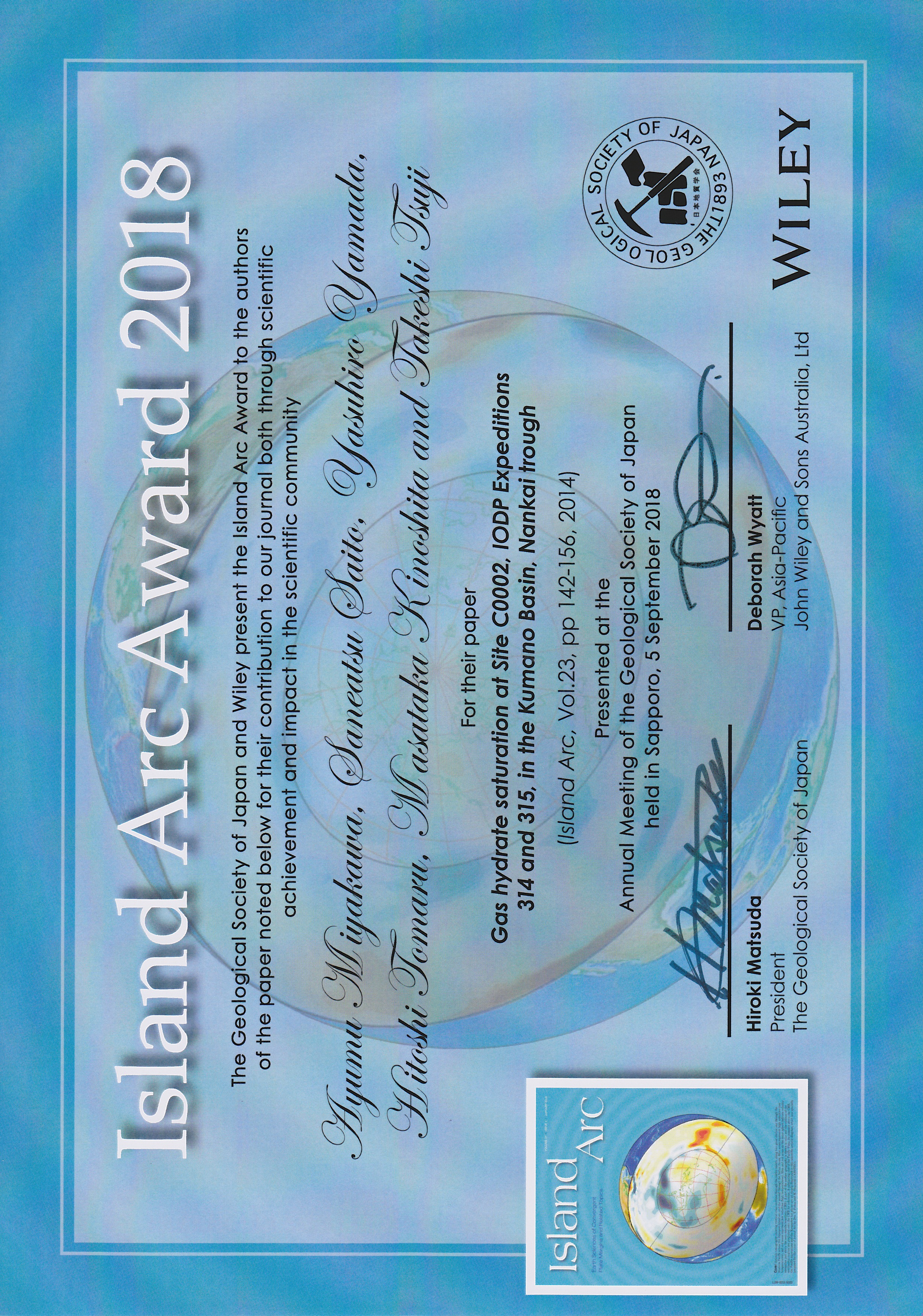 受賞論文:Ayumu Miyakawa, Saneatsu Saito, Yasuhiro Yamada, Hitoshi Tomaru, Masataka Kinoshita and Takeshi Tsuji, 2014, Gas hydrate saturation at Site C0002, IODP Expeditions 314 and 315, in the Kumano Basin, Nankai trough. Island Arc, 23, 142–156.
Miyakawa et al. (2014) estimated the degree of gas hydrate saturation at IODP Site C0002 in the Kumano Basin, Nankai Trough from logging-while-drilling logs and core samples obtained during IODP Expeditions 314 and 315 using Deep Sea Drilling Vessel Chikyu. Based on the excellent geophysical and geochemical data, the free gas migration in sediment is well illustrated. They found coexistence of gas hydrate and free gas, suggesting a large gas flux flowing to the southern and seaward edge of the basin from a deeper part of the Kumano Basin. This knowledge is applicable to various kinds of pore fluids and thus important to consider digenetic process of sedimentary rocks. This paper presents one of important results of gas hydrate formation obtained by the NanTroSEIZE drilling program using Chikyu. Their work has been broadly cited as the standard of the gas hydrate saturation in the seaward edge of the Kumano Basin, Japan. In addition, their findings motivate further studies on the coexistence of gas hydrate and free gas and the fluid migration in the area.
Ayumu Miyakawa graduated from Kyoto University with a BSc in 2006; he subsequently completed a Ph.D. course at the same university with the degree in 2011. He became a Postdoctoral Researcher at Japan Agency for Marine-Earth Science and Technology (JAMSTEC) in 2011; he served there for one year. In April 2012, he started his engagement in research at the Geological Survey of Japan (GSJ) in the National Institute of Advanced Industrial Science and Technology (AIST); he is a Senior Researcher since October 2017. His main interest is in the dynamics of subduction zones. He joined Nankai Trough Seismogenic Zone Experiment as an onboard logging scientist in IODP Expedition 314. The logging data obtained during the cruse revealed the fluid migration and the hydrate deposition within the forearc basin, as mentioned in the awarded article. He is also curious about the integration of the geological/geophysical observation such as the logging data and the geodynamics modeling. He is conducting the numerical modeling to simulate the dynamics of the subduction zones. Currently, he is expanding his research to crustal stress controlling the reactivation of the fault and the openness of the fault-fracture conduit in the crust.
藤田 航平助教、市村 強教授らが 第23回計算工学 講演会ベストペーパーアワードを受賞
藤田 航平助教、市村 強教授らの論文が、 第23回計算工学 講演会ベストペーパーアワードを受賞しました。
受賞論文:大規模非線形粘弾性有限要素計算に基づいた地震サイクルシミュレーション
著者:縣 亮一郎(海洋研究開発機構) 、Sylvain D. Barbot(南洋理工大学)、藤田 航平(東京大学)、兵藤 守(海洋研究開発機構)、飯沼 卓史(海洋研究開発機構)、中田 令子(海洋研究開発機構)、市村 強(東京大学)、堀 高峰(海洋研究開発機構)
表彰理由:研究の質・完成度が高く、研究の重要性や期待度、将来性が高く評価されました。
https://www.jsces.org/koenkai/23/
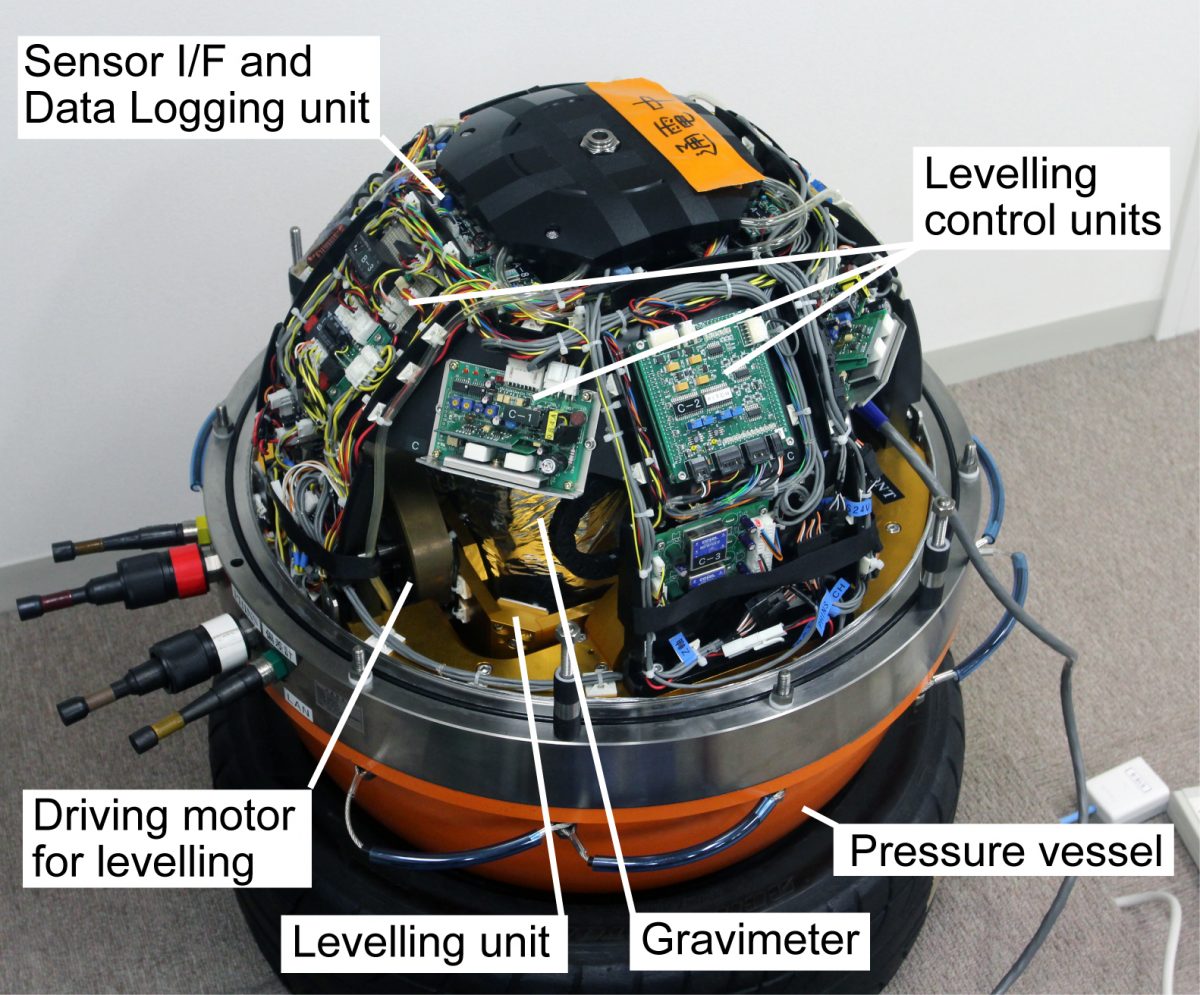
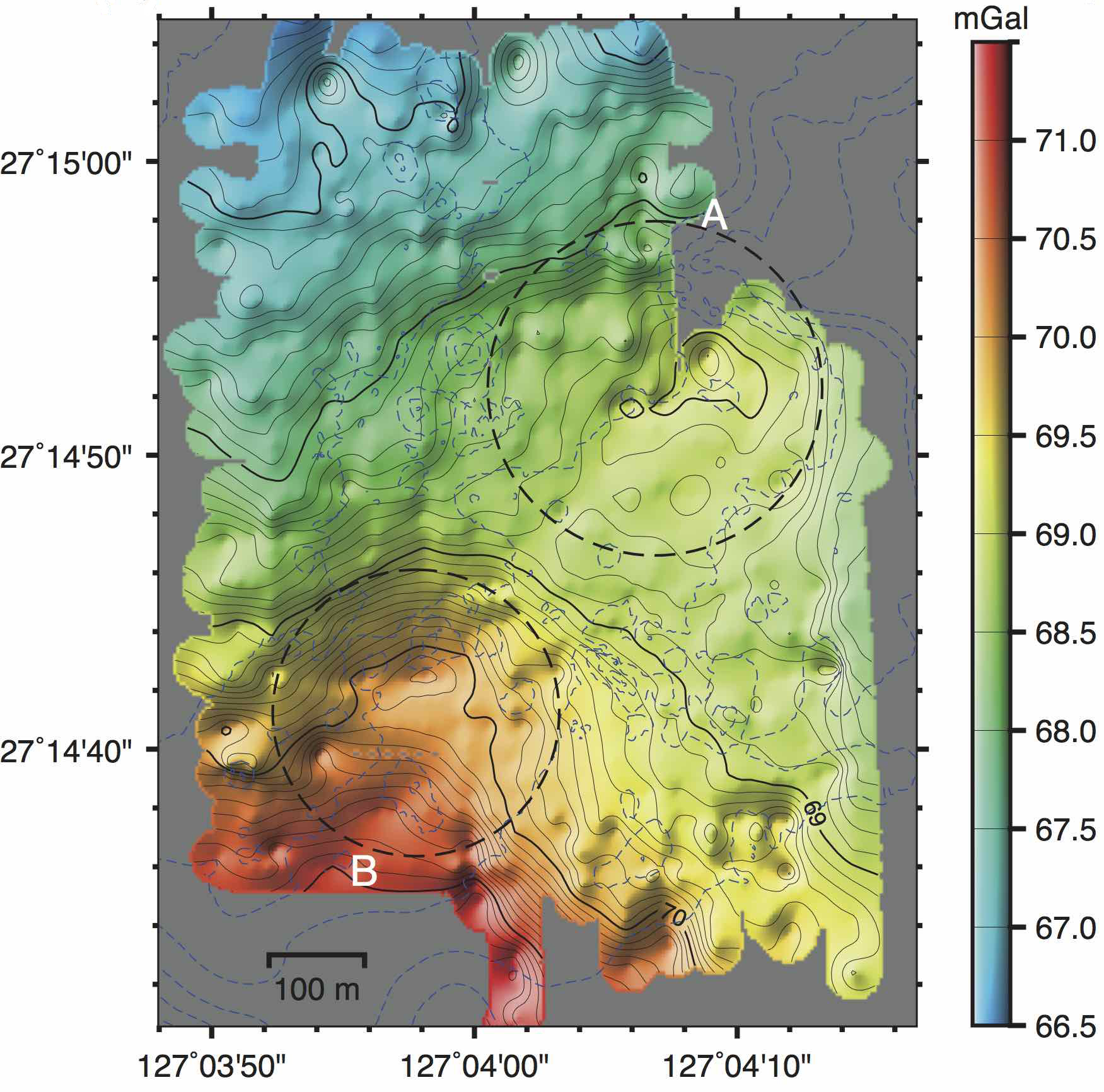
自立型無人潜水機に搭載した海中重力計測システムの開発と実海域における高分解能測定
Shinohara, M., T. Kanazawa, H. Fujimoto, T. Ishihara, T. Yamada, A. Araya, S. Tsukioka, S. Omika, T. Yoshiume, M. Mochizuki, K. Uehira, and K. Iizasa
Development of a high-resolution underwater gravity measurement system installed on an autonomous underwater vehicle
IEEE Geoscience and Remote Sensing Letters, 15, 12, 1937 – 1941, doi:10.1109/LGRS.2018.2863261, 2018.
Ishihara, T., M. Shinohara, H. Fujimoto, T. Kanazawa, A. Araya, T. Yamada, K. Iizasa, S. Tsukioka, S. Omika, T. Yoshiume, M Mochizuki and K. Uehira
High-resolution gravity measurement aboard an autonomous underwater vehicle
Geophysics, 83, 6, G119 – G135, doi:10.1190/GEO2018-0090.1, 2018.
日本周辺海域には海底熱水鉱床が存在しており、その分布や規模の詳細を明らかにすることが期待されている。また、活断層などの海底下の活構造を明らかにすることも重要である。海底近傍での分解能が高い重力異常のマッピングは、これらの目的のための地下構造の解析に有益である。そこで、重力異常を高精度で探査できる海中移動体搭載型の重力探査システムを開発した。
重力探査システムのうち、海中重力計システムには海中測定用に改良した海上重力計を採用し、重力計は高精度ジャイロを用いたレベリング機構に搭載して鉛直を保持する。レベリング機構とそれを制御するエレクトロニクスは、直径約50 cm のチタン合金製耐圧球に収納した。また、海中移動体には、海洋研究開発機構が運用している深海巡航探査機「うらしま」を採用し、電源供給や音響による支援母船との通信などの各種機能の強化と共に、重力測定に適した安定した航行が可能な技術の開発も行った。さらにデータ解析方法についても、海中測定のための開発・改良を行った。2012年に相模湾において実海域実証試験を実施し、探査に必要である0.1mGalの精度が得られた。2015年に、鉱床の存在が推定されている中部沖縄トラフ伊是名海穴にて、「うらしま」による実証観測を実施した。その結果、高重力異常を検出し、これらの異常が周囲との密度差1.5g/cm3の鉱床に起因するとすれば、直径300m程度、厚さ数十mの鉱床の存在が推定される。また、ベヨネーズ海丘においても実海域実証試験を実施して、高精度な重力異常分布が得られた。

【2月15日】第83回 知の拠点セミナー開催
第83回 知の拠点セミナー が2月15日(金)に地震研究所で開催されます。
知の拠点セミナーは、学問の最先端の様子を一般の方々や学生の方々にお届けするために、国立大学共同利用・共同研究拠点協議会が毎月開催しているセミナーです。6月から地震研究所で開催することになりました。
セミナーの内容や参加申し込み等の詳細は、下記のウェブサイトをご覧ください。
【1月18日】第82回 知の拠点セミナー開催
第82回 知の拠点セミナー が1月18日(金)に地震研究所で開催されます。
知の拠点セミナーは、学問の最先端の様子を一般の方々や学生の方々にお届けするために、国立大学共同利用・共同研究拠点協議会が毎月開催しているセミナーです。6月から地震研究所で開催することになりました。
セミナーの内容や参加申し込み等の詳細は、下記のウェブサイトをご覧ください。
http://www.kyoten.org/seminar/H30/82/
2018年インドネシア・クラカタウ火山噴火・津波
2018年12月22日(現地時間21時頃, UTC14時頃),インドネシア・ジャワ島とスマトラ島に挟まれるスンダ海峡において津波が発生し,クラカタウに近い沿岸域において大きな災害が生じた。噴火活動を続けているアナク・クラカタウ島の南西側が大きく崩壊している様子が明らかになったことから,津波はこの火山島の山体崩壊に伴い発生したと考えられている(PVMBG*1)。
アナク・クラカタウ島では現在も噴火活動が続いており,その推移が注目される中,今回の崩壊イベントにおける崩壊量や崩壊プロセス,沿岸への津波の伝搬過程,さらにこれらと噴火活動との関係は,日本国内の類似事例の理解を進めるためにも早急に解明する必要があろう。そこで,アナク・クラカタウ島の崩壊と周辺への津波伝搬のシミュレーションを行ったので,その暫定的な結果について報告する。アナク・クラカタウ島は,1883年の巨大噴火で形成されたクラカタウ・カルデラの北東縁に成長した新しい火山島である(Fig. 1, 2)。 崩壊前は,東西2.1 km,南北2.3 kmの大きさで,標高300 mを超える中央火砕丘と山麓にかけて広がる溶岩流からなる島であった(Fig. 3)。山体南西斜面は水深約270 mのカルデラ底まで続き,急峻な地形をなしていた。今回の崩壊はこの南西側で発生し,山頂を含む島の約半分が失われたと考えられる。
詳細については,火山噴火予知研究センターのページをご参照ください.
Ye Lingling氏が2018 Keiiti Aki Young Scientist Awardを受賞
Ye Lingling特任研究員(国際室長期招聘)が、2018 Keiiti Aki Young Scientist Awardを受賞しました。
地震史料シンポジウムが本学HPで紹介されました
11月30日に開催された地震史料シンポジウム「地域史料から地震学へのアプローチ」が、本学ウェブサイトのArticlesにて紹介されました。
https://www.u-tokyo.ac.jp/focus/ja/articles/z0206_00005.html